
- Elevation
- 1,498 m
- above sea level
- Local time
- UTC+09:00
- Asia/Tokyo · UTC+09:00
- Airports
- CTS New Chitose Airport62 km
- OBO Tokachi-Obihiro Airport63 km
About Mount Iwanai
Mount Iwanai is a mountain. Location: Hidaka Chō, Saru-gun. Elevation: 1,498 m.
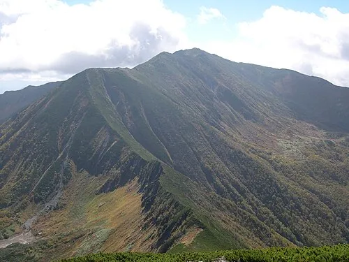
Mount Iwanai (岩内岳, Iwanai-dake) is located in the Hidaka Mountains, Hokkaidō, Japan.
Source: Wikipedia · CC BY-SA 4.0
Photos of Mount Iwanai
-

Nukabira Yama Yasu · CC BY-SA 3.0

Climate of Mount Iwanai
This month · November
A wet month
Day -1° · Night -9° · Rain 101 mm
- Hottest month
- August (day 15°)
- Coldest month
- January (night -20°)
- Wettest month
- September (159 mm)
- Driest month
- February (49 mm)
Bars: average monthly low and high temperature. Below: precipitation. Monthly averages for 1970–2000 at about 18 km resolution, adjusted for elevation. Highlighted months are mild and relatively dry. Source: WorldClim 2.1 (CC BY 4.0).
Show values as a table
| Month | Jan | Feb | Mar | Apr | May | Jun | Jul | Aug | Sep | Oct | Nov | Dec |
|---|---|---|---|---|---|---|---|---|---|---|---|---|
| Average high (°C) | -10° | -10° | -6° | 0° | 6° | 10° | 14° | 15° | 11° | 6° | -1° | -7° |
| Average low (°C) | -20° | -20° | -15° | -8° | -3° | 2° | 7° | 8° | 3° | -4° | -9° | -16° |
| Precipitation (mm) | 61 | 49 | 69 | 85 | 99 | 96 | 131 | 158 | 159 | 133 | 101 | 68 |
How to get to Mount Iwanai
The nearest airport is New Chitose Airport (CTS), 62 km to the west as the crow flies. The nearest large city is Obihiro, 63 km to the east.
Airports
- New Chitose Airport (CTS) Sapporo 62 kmwest
- Tokachi-Obihiro Airport (OBO) Obihiro 63 kmeast
- Sapporo Okadama Airport (OKD) Sapporo 94 kmwest
Nearby large cities
- Obihiro Population: 166.5K 63 kmeast
- Tomakomai Population: 174.8K 72 kmwest
- Ebetsu Population: 134K 81 kmnorthwest
- Sapporo Population: 2M 95 kmwest
- Asahikawa Population: 333.5K 108 kmnorth
Straight-line distances; road distances are longer. Airport data: OurAirports.
Day trips from Mount Iwanai
Within 100 km: 2 historic and cultural sites, 60 natural sites, 9 lakes, rivers and coasts.
0–25 km4 places
- Mount Poroshiri Mountain 21 kmSE
- Mount Tottabetsu Mountain 21 kmE
- Nukabira Yama Mountain 5 kmSE
- Mount Futamata Mountain 14 kmE
25–60 km28 places
- Saru River River 49 kmSW
- Mount Rutori Mountain 53 kmSE
- Pon’yaoromappu Dake Mountain 51 kmSE
- Niikappu River River 50 kmS
60–100 km39 places
- Hokkaido Island 81 kmNE
- Mount Maru Mountain 90 kmSE
- Mount Daimaru Mountain 89 kmSE
- Mount Tengu Mountain 97 kmSE
Straight-line distances.
Nearest towns and villages
-
 Biratori Chō Municipality, Saru-gun13 km SW
-
 Mukawa Chō Municipality, Yūfutsu-gun26 km W
-
 Shimukappu Village, Yūfutsu-gun22 km N
-
 Niikappu Chō Municipality, Niikappu-gun28 km S
-
 Minamifurano Chō Municipality, Sorachi-gun42 km N
-
 Shinhidaka Chō Municipality, Hidaka-gun44 km S
Nearby attractions & nature
Everything nearby-
Nukabira Yama Mountain, Biratori Chō5.1 km SE
-
 Mount Poroshiri Mountain, Biratori Chō21 km SE
-
 Mount Futamata Mountain, Hidaka Chō14 km E
-
Mount Tottabetsu Mountain, Niikappu Chō21 km E
Sources & licences
Data last updated: · 2 independent sources