- Local time
- UTC+03:00
- Europe/Istanbul · UTC+03:00
- Airports
- ADB Adnan Menderes International Airport36 km
- JKH Chios Island National Airport55 km
About Vourla Bay
Vourla Bay is a natural site. Location: İzmir Province, Turkey. The best months to visit are May, October. The nearest airport is Adnan Menderes International Airport (36 km). Nearby sights include İncirli Adası and Pırnallı Adası.
Photos of Vourla Bay
-
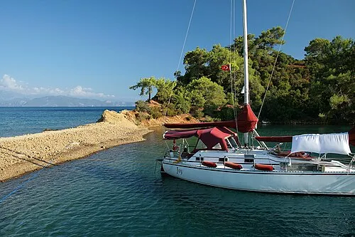
Saint John Island Jorge Franganillo · CC BY-SA 4.0

Climate of Vourla Bay
Best months for sightseeingBest months for sightseeing: May, October.
This month · November
Outside the best season
Day 17° · Night 10° · Rain 79 mm
Better nearby cities in November
- Aydin · 112 km southeast19°
- Hottest month
- July (day 31°)
- Coldest month
- January (night 5°)
- Wettest month
- December (131 mm)
- Driest month
- August (3 mm)
Bars: average monthly low and high temperature. Below: precipitation. Monthly averages for 1970–2000 at about 18 km resolution, adjusted for elevation. Highlighted months are mild and relatively dry. Source: WorldClim 2.1 (CC BY 4.0).
Show values as a table
| Month | Jan | Feb | Mar | Apr | May | Jun | Jul | Aug | Sep | Oct | Nov | Dec |
|---|---|---|---|---|---|---|---|---|---|---|---|---|
| Average high (°C) | 12° | 13° | 15° | 19° | 24° | 29° | 31° | 31° | 28° | 23° | 17° | 14° |
| Average low (°C) | 5° | 5° | 7° | 10° | 14° | 18° | 21° | 21° | 18° | 14° | 10° | 7° |
| Precipitation (mm) | 113 | 88 | 73 | 41 | 26 | 7 | 4 | 3 | 13 | 41 | 79 | 131 |
How to get to Vourla Bay
The nearest airport is Adnan Menderes International Airport (ADB), 36 km to the east as the crow flies. The nearest large city is Çiğli, 29 km to the northeast.
Airports
- Adnan Menderes International Airport (ADB) Gaziemir 36 kmeast
- Chios Island National Airport (JKH) Chios Island 55 kmwest
- Mytilene International Airport (MJT) Mytilene 75 kmnorth
Nearby large cities
- Çiğli Population: 214.1K 29 kmnortheast
- Konak Population: 332.3K 29 kmeast
- Cordaleo Population: 339.6K 31 kmeast
- Karabağlar Population: 479.3K 32 kmeast
- Izmir Population: 2.9M 32 kmeast
Straight-line distances; road distances are longer. Airport data: OurAirports.
Day trips from Vourla Bay
Within 100 km: 75 historic and cultural sites, 188 natural sites, 199 lakes, rivers and coasts.
0–25 km74 places
- Chustan Island Island 13 kmN
- Taş Adası Island 2 kmSE
- Hekim Adasi Island 6 kmN
- Eşek Adası Island 22 kmS
25–60 km191 places
- Panaghia Mirtidhiotisa Monastery Attraction 55 kmW
- Karabel relief Historic site 60 kmE
- Uzunadalar Island 40 kmW
- Platia Islet Island 34 kmW
60–100 km197 places
- Moní Megális Panagías Attraction 78 kmS
- Aghia Matrona Attraction 61 kmW
- Kadınlar Plajı Beach 74 kmSE
- Theopori Island Island 85 kmS
Straight-line distances.
Nearest towns and villages
Nearby attractions & nature
Everything nearby-
İncirli Adası Island, İzmir Province1.7 km N
-
Pırnallı Adası Island, İzmir Province1.5 km E
-
Saint John Island Island, İzmir Province2.8 km NE
-
Adacık Island, İzmir Province1.8 km W
-
Taş Adası Island, İzmir Province1.8 km SE
-
Çiçek Adaları Island, İzmir Province2.1 km NE
-
Arap Adaları Island, İzmir Province2.3 km N
-
Clazomene Island Island, İzmir Province2.6 km SE
Sources & licences
Data last updated: