- Elevation
- 3,756 m
- above sea level
- Local time
- UTC+03:00
- Europe/Istanbul · UTC+03:00
- Airports
- COV Çukurova International Airport103 km
- ASR Kayseri Erkilet International Airport110 km
About Demirkazık Tepe
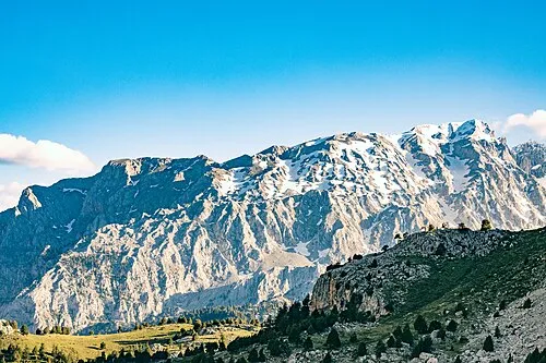
Demirkazık Tepe is a mountain. Location: Yahyali, Kayseri Province. Elevation: 3,756 m. The nearest airport is Çukurova International Airport (103 km). Nearby sights include Torasan Dağı and Karpuzbaşı Şelalesi.
Climate of Demirkazık Tepe
This month · November
A cold month
Day -4° · Night -13° · Rain 50 mm
Better nearby cities in November
- Adana · 93 km south21°
- Tarsus · 103 km south22°
- Mersin · 121 km southwest22°
- Hottest month
- August (day 12°)
- Coldest month
- January (night -20°)
- Wettest month
- April (80 mm)
- Driest month
- August (9 mm)
Bars: average monthly low and high temperature. Below: precipitation. Monthly averages for 1970–2000 at about 18 km resolution, adjusted for elevation. Highlighted months are mild and relatively dry. Source: WorldClim 2.1 (CC BY 4.0).
Show values as a table
| Month | Jan | Feb | Mar | Apr | May | Jun | Jul | Aug | Sep | Oct | Nov | Dec |
|---|---|---|---|---|---|---|---|---|---|---|---|---|
| Average high (°C) | -12° | -11° | -7° | -1° | 4° | 8° | 12° | 12° | 9° | 3° | -4° | -10° |
| Average low (°C) | -20° | -19° | -16° | -11° | -7° | -5° | -2° | -3° | -6° | -9° | -13° | -17° |
| Precipitation (mm) | 60 | 56 | 72 | 80 | 76 | 40 | 10 | 9 | 17 | 44 | 50 | 73 |
How to get to Demirkazık Tepe
The nearest airport is Çukurova International Airport (COV), 103 km to the south as the crow flies. The nearest large city is Adana, 93 km to the south.
Airports
- Çukurova International Airport (COV) Tarsus 103 kmsouth
- Kayseri Erkilet International Airport (ASR) Kayseri 110 kmnorth
- Nevşehir Kapadokya Airport (NAV) Nevşehir 120 kmnorthwest
Nearby large cities
- Adana Population: 1.8M 93 kmsouth
- Tarsus Population: 350.7K 103 kmsouth
- Heraclea Population: 156.3K 104 kmwest
- Kayseri Population: 1.5M 105 kmnorth
- Aksaray Population: 327.6K 118 kmnorthwest
Straight-line distances; road distances are longer. Airport data: OurAirports.
Day trips from Demirkazık Tepe
Within 100 km: 19 historic and cultural sites, 265 natural sites, 174 lakes, rivers and coasts.
0–25 km32 places
- Ziyaret Tepesi Mountain 15 kmNW
- Torasan Dağı Mountain 3 kmSE
- Ak Tepe Mountain 25 kmNW
- Deliktaş Tepesi Mountain 24 kmNW
25–60 km130 places
- Yaygölü Lake 58 kmN
- Camız Gölü Lake 53 kmN
- Uluağaç Göleti Lake 36 kmNW
- Ziyaret Tepe Mountain 53 kmE
60–100 km296 places
- Söbe Göl Lake 68 kmN
- Yağızlar Göleti Lake 76 kmSE
- Kanlı Gölü Lake 95 kmN
- Acıgöl Lake 85 kmNW
Straight-line distances.
Nearest towns and villages
-
Emmi Yaylası Village, Çamardı District7.3 km W
-
 Bademdere Village, Çamardı District14 km NW
-
Demirkazık Village, Çamardı District8.1 km NW
-
Pınarbaşı Village, Çamardı District9.2 km NW
-
Çukurbağ Village, Çamardı District9.8 km W
-
Eynelli Village, Çamardı District19 km NW
Nearby attractions & nature
Everything nearby-
Torasan Dağı Mountain, Yahyali3.5 km SE
-
Karpuzbaşı Şelalesi Natural site, Niğde Province8.4 km W
-
 Anti-Taurus Mountains Mountain, Turkey12 km N
-
Aladağlar Milli Parkı Natural site, Çamardı District9.4 km S
-
Ecemiş Deresi River, Turkey9 km NW
-
Kaltar Dağı Mountain, Aladağ17 km S
-
Ebe Tepe Mountain, Aladağ20 km SE
-
Kızılcameşe Çeşmesi Natural site, Niğde Province14 km NW
Sources & licences
Data last updated: