- Population
- 132,665
- 132.7K
- Elevation
- 17 m
- above sea level
- Local time
- UTC+03:00
- Europe/Istanbul · UTC+03:00
- Airports
- COV Çukurova International Airport117 km
- ECN Ercan International Airport141 km
About Silifke
Silifke is a city. Location: Silifke İlçesi, Mersin Province. Population: 132,665. Elevation: 17 m. The best months to visit are April, November. The nearest airport is Çukurova International Airport (117 km). Nearby sights include Çamlı Tepe and Bahçe Deresi.
Climate of Silifke
Best months for sightseeingBest months for sightseeing: April, November.
This month · November
A good month to visit
Day 21° · Night 11° · Rain 78 mm
- Hottest month
- August (day 34°)
- Coldest month
- January (night 6°)
- Wettest month
- December (139 mm)
- Driest month
- August (2 mm)
Bars: average monthly low and high temperature. Below: precipitation. Monthly averages for 1970–2000 at about 18 km resolution, adjusted for elevation. Highlighted months are mild and relatively dry. Source: WorldClim 2.1 (CC BY 4.0).
Show values as a table
| Month | Jan | Feb | Mar | Apr | May | Jun | Jul | Aug | Sep | Oct | Nov | Dec |
|---|---|---|---|---|---|---|---|---|---|---|---|---|
| Average high (°C) | 14° | 16° | 19° | 23° | 27° | 31° | 34° | 34° | 32° | 28° | 21° | 16° |
| Average low (°C) | 6° | 7° | 9° | 13° | 17° | 21° | 24° | 24° | 21° | 16° | 11° | 8° |
| Precipitation (mm) | 127 | 96 | 70 | 41 | 30 | 12 | 7 | 2 | 8 | 46 | 78 | 139 |
How to get to Silifke
The nearest airport is Çukurova International Airport (COV), 117 km to the northeast as the crow flies. The nearest large city is Mersin, 79 km to the northeast.
Airports
- Çukurova International Airport (COV) Tarsus 117 kmnortheast
- Ercan International Airport (ECN) Tymbou (Kirklar) 141 kmsouth
- Gazipaşa-Alanya Airport (GZP) Gazipaşa 147 kmwest
Nearby large cities
- Mersin Population: 537.8K 79 kmnortheast
- Tarsus Population: 350.7K 105 kmnortheast
- Karaman Population: 175.4K 110 kmnorthwest
- Heraclea Population: 156.3K 126 kmnorth
- Adana Population: 1.8M 141 kmnortheast
Straight-line distances; road distances are longer. Airport data: OurAirports.
Day trips from Silifke
Within 100 km: 87 historic and cultural sites, 1,039 natural sites, 168 lakes, rivers and coasts.
0–25 km30 places
- Boğsak Adası Island 16 kmSW
- Paradeniz Gölü Lake 11 kmSE
- Ak Göl Lake 9 kmS
- Karakuz Dağı Mountain 21 kmSW
25–60 km328 places
- Ovacık Adası Island 33 kmSW
- Dana Adası Island 25 kmSW
- Babadil Adası Island 46 kmSW
- Büyük Ada Island 59 kmSW
60–100 km936 places
- Nisídes Kordýlia Island 94 kmSE
- Nisída Gláros Island 92 kmSE
- Nisída Lefkónisos Island 92 kmSE
- Nisídes Skaloúdia Island 93 kmS
Straight-line distances.
Silifke and similar cities
Side by side with cities of similar size in the same country: population, elevation and climate.
| Measure | Silifke | İnegöl | Cizre | Mardin |
|---|---|---|---|---|
| Population | 132.7K | 134K | 134K | 129.9K |
| Elevation | 17 m | 293 m | 380 m | 1,056 m |
| Summer day (hottest month) | 34° | 30° | 42° | 37° |
| Winter night (coldest month) | 6° | -1° | 3° | -3° |
| Annual rainfall | 656 mm | 519 mm | 648 mm | 551 mm |
| Best months | Apr, Nov | May–Jun, Sep–Oct | Apr, Oct–Nov | May, Oct |
| Distance | — | 564 km | 743 km | 616 km |
Climate values are 1970–2000 monthly averages; straight-line distance.
Nearby attractions & nature
Everything nearby-
Çamlı Tepe Mountain, Silifke İlçesi8.1 km N
-
Bahçe Deresi River, Mersin Province5.8 km SW
-
Topallar Çeşmesi Natural site, Mersin Province6.5 km NE
-
Örmece Tepesi Mountain, Silifke İlçesi10 km N
-
Kargacı Tepesi Mountain, Silifke İlçesi13 km NW
-
Ak Göl Lake, Mersin Province8.7 km S
-
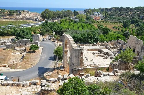 Elaiussa Sebaste Historic site, Erdemli İlçesi24 km NE
-
Kara Dağ Mountain, Silifke İlçesi25 km NE
Other cities and towns in Silifke İlçesi
Sources & licences
Data last updated: