Tunceli Province
Local name: Tunceli ili
Located in Turkey Coordinates: 39°06′26″ N 39°32′51″ E
- Population
- 84,366
- 84.4K
- Elevation
- 967 m
- above sea level
- Local time
- UTC+03:00
- Europe/Istanbul · UTC+03:00
- Places inside
- 128
- listed under Tunceli Province
- Airports
- EZS Elazığ Airport61 km
- ERC Erzincan Airport67 km
About Tunceli Province
Tunceli Province is a region. Location: Turkey. Population: 84,366.
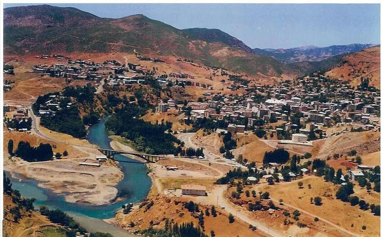
Tunceli Province (Turkish: Tunceli ili), formerly Dersim Province (Kurdish: Parêzgeha Dêrsim; Zazaki: Dêsim wilayet; Armenian: Տէրսիմի մարզ), is a province in the Eastern Anatolia region of Turkey. Its central city is Tunceli. The province has a Kurdish majority. Moreover, it is the only province in Turkey with an Alevi majority. The province has eight municipalities, 366 villages and 1,087 hamlets.
Source: Wikipedia · CC BY-SA 4.0
Places bordering Tunceli Province
Climate of Tunceli Province
Best months for sightseeingBest months for sightseeing: May, October.
This month · November
A wet month
Day 13° · Night 4° · Rain 103 mm
Better nearby cities in November
- Viranşehir · 210 km south18°
- Kızıltepe · 232 km southeast19°
- Suruç · 257 km southwest20°
- Hottest month
- July (day 35°)
- Coldest month
- January (night -4°)
- Wettest month
- December (128 mm)
- Driest month
- August (4 mm)
Bars: average monthly low and high temperature. Below: precipitation. Monthly averages for 1970–2000 at about 18 km resolution, adjusted for elevation. Highlighted months are mild and relatively dry. Source: WorldClim 2.1 (CC BY 4.0).
Show values as a table
| Month | Jan | Feb | Mar | Apr | May | Jun | Jul | Aug | Sep | Oct | Nov | Dec |
|---|---|---|---|---|---|---|---|---|---|---|---|---|
| Average high (°C) | 3° | 5° | 11° | 18° | 24° | 30° | 35° | 35° | 30° | 22° | 13° | 6° |
| Average low (°C) | -4° | -3° | 2° | 7° | 12° | 16° | 20° | 19° | 15° | 10° | 4° | -1° |
| Precipitation (mm) | 107 | 95 | 98 | 105 | 77 | 23 | 6 | 4 | 11 | 63 | 103 | 128 |
How to get to Tunceli Province
The nearest airport is Elazığ Airport (EZS), 61 km to the south as the crow flies. The nearest large city is Elâzığ, 56 km to the southwest.
Airports
- Elazığ Airport (EZS) Elazığ 61 kmsouth
- Erzincan Airport (ERC) Erzincan 67 kmnorth
- Bingöl Airport (BGG) Bingöl 95 kmeast
Nearby large cities
- Elâzığ Population: 443.4K 56 kmsouthwest
- Erzincan Population: 150.7K 70 kmnorth
- Bingoel Population: 128.9K 86 kmeast
- Malatya Population: 750.5K 136 kmsouthwest
- Diyarbakır Population: 1.8M 145 kmsoutheast
Straight-line distances; road distances are longer. Airport data: OurAirports.
Places in Tunceli Province
128 places- 1 Tunceli 36.1K
- 2 Pertek İlçesi 11.9K
- 3 Mazgirt İlçesi 8.7K
- 4 Ovacık İlçesi 6.6K
- 5 Hozat İlçesi 3.6K
- 6 Pülümür İlçesi 3.6K
- 7 Nazımiye İlçesi 3K
- 8 Çemişgezek İlçesi 3K
Bar: population relative to the most populous place in this list.
Cities & villages17
- Akçapınar Bucağı · Municipality
- Akdemir Bucağı · Municipality
- Akpazar Bucağı · Municipality
- Aşağıkazan · Village
- Balpayam Bucağı · Municipality
- Büyükyurt Bucağı · Municipality
- Çağlarca Bucağı · Municipality
- Çemişgezek Bucağı · Municipality
- Çiçekli Bucağı · Municipality
- Çırmık · Village
- Dağyolu Bucağı · Municipality
- Dallıbahçe Bucağı · Municipality
- Darıkent Bucağı · Municipality
- Dere Bucağı · Municipality
- Gedikler Bucağı · Municipality
- Gökçe · Village
- Harikhopu · Village
Mountains & nature6
- Ardıçdağları · Mountain
- Boncuk Dağı · Mountain
- Çelemelik Dağı · Mountain
- Eğripınar Dağı · Mountain
- Gedik Tepe · Mountain
- Hanım Pınarları · Natural site
Lakes, rivers & coasts29
- Ağviran Deresi · River
- Aksu Deresi · River
- Aksu Deresi · River
- Aliboğaz Deresi · River
- Amergan Deresi · River
- Balıkuşağı Deresi · River
- Bekir Dere · River
- Büyükalan Deresi · River
- Büyükçay Deresi · River
- Büyük Dere · River
- Büyük Dere · River
- Büyük Dere · River
- Çalı Dere · River
- Çat Dere · River
- Çat Deresi · River
- Çayırlık Dere · River
- Çiğli Çayı · River
- Danaburan Deresi · River
- Değirmen Dere · River
- Değirmen Deresi · River
- Dereva Deresi · River
- Düldül Deresi · River
- Ekerek Deresi · River
- Esence Çayı · River
- Göğem Dere · River
- Güllühan Dere · River
- Haçili Deresi · River
- Harami Deresi · River
- Havaçor Deresi · River
Largest cities and towns
Nature and heritage in Tunceli Province
Sources & licences
Data last updated: · 2 independent sources