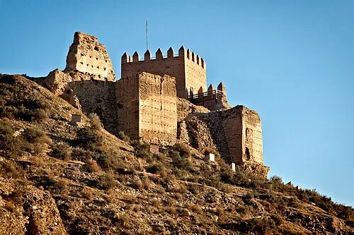
Castillo de Gergal
Located in Gérgal, Almeria Coordinates: 37°07′19″ N 2°32′16″ W
- Local time
- UTC+01:00
- Europe/Madrid · UTC+01:00
- Elevation
- 773 m
- above sea level
About Castillo de Gergal
Castillo de Gergal is a historic site. Location: Gérgal, Almeria.
Airports nearest to Castillo de Gergal
- Almería Airport (LEI) Almería 34 km
- F.G.L. Airport Granada-Jaén Airport (GRX) Granada 110 km
- Region of Murcia International Airport (RMU) Corvera 146 km
Straight-line distance; airports with scheduled flights only. Source: OurAirports (public domain).
Nearby attractions & nature
Everything nearby-
Iglesia Parroquial de Santa María Attraction, Gérgal0.2 km SW
-
 Castillo de Tabernas Historic site, Tabernas15 km SE
-
El Peñón del Moro Historic site, Alboloduy12 km SW
-
Fuerte El Condor Historic site, Tabernas12 km SE
-
Nueva Frontera Historic site, Tabernas13 km SE
-
Centro de Interpretación Terrera Ventura Museum, Tabernas15 km SE
-
Iglesia Parroquial de Ntra. Sra. de la Encarnación Attraction, Tabernas15 km SE
-
Igleisa de Santiago Apostol Attraction, Terque16 km S
Nearest towns and villages
-
Gérgal Village, Gérgal0.4 km SW
-
Porto-Carrero Village, Gérgal5.1 km N
-
Olula de Castro Municipality, Almeria7 km NE
-
El Arroyo de Verdelecho Village, Gérgal5.9 km E
Sources & licences
Data last updated: