
- Population
- 5
- 5
- Elevation
- 1,062 m
- above sea level
- Local time
- UTC+01:00
- Europe/Madrid · UTC+01:00
- Airports
- ZAZ Zaragoza Airport85 km
- RJL Logroño-Agoncillo Airport96 km
About Tordesalas
Tordesalas is a village. Location: Torrubia de Soria, Soria. Population: 5. Elevation: 1,062 m. The best months to visit are June, September. The nearest airport is Zaragoza Airport (85 km). Nearby sights include castle of Peñalcazar and Sierra de Toranzos.
Climate of Tordesalas
Best months for sightseeingBest months for sightseeing: June, September.
This month · November
A cold month
Day 11° · Night 1° · Rain 43 mm
Better nearby cities in November
- Alicante · 388 km south20°
- Elche · 391 km south20°
- Alicante · 388 km south20°
- Hottest month
- August (day 28°)
- Coldest month
- January (night -2°)
- Wettest month
- May (61 mm)
- Driest month
- August (25 mm)
Bars: average monthly low and high temperature. Below: precipitation. Monthly averages for 1970–2000 at about 18 km resolution, adjusted for elevation. Highlighted months are mild and relatively dry. Source: WorldClim 2.1 (CC BY 4.0).
Show values as a table
| Month | Jan | Feb | Mar | Apr | May | Jun | Jul | Aug | Sep | Oct | Nov | Dec |
|---|---|---|---|---|---|---|---|---|---|---|---|---|
| Average high (°C) | 7° | 9° | 13° | 14° | 18° | 23° | 28° | 28° | 24° | 17° | 11° | 8° |
| Average low (°C) | -2° | -1° | 0° | 2° | 6° | 9° | 12° | 11° | 9° | 5° | 1° | -1° |
| Precipitation (mm) | 38 | 37 | 30 | 50 | 61 | 46 | 27 | 25 | 32 | 47 | 43 | 46 |
How to get to Tordesalas
The nearest airport is Zaragoza Airport (ZAZ), 85 km to the east as the crow flies. The nearest large city is Zaragoza, 99 km to the east.
Airports
- Zaragoza Airport (ZAZ) Zaragoza 85 kmeast
- Logroño-Agoncillo Airport (RJL) Logroño 96 kmnorth
- Pamplona Airport (PNA) Pamplona 132 kmnorth
Nearby large cities
- Zaragoza Population: 687K 99 kmeast
- Logroño Population: 151.2K 99 kmnorth
- Pamplona Population: 208.2K 137 kmnorth
- Vitoria-Gasteiz Population: 257.4K 145 kmnorth
- Burgos Population: 176.4K 158 kmnorthwest
Straight-line distances; road distances are longer. Airport data: OurAirports.
Day trips from Tordesalas
Within 100 km: 198 historic and cultural sites, 98 natural sites, 167 lakes, rivers and coasts.
0–25 km5 places
- Río Araviana River 9 kmNW
- Arroyo de la Muta River 19 kmNE
- Sierra de Toranzos Mountain 16 kmNE
- Sierra Tablado Mountain 21 kmE
25–60 km117 places
- Pantano de la Nava Lake 52 kmNE
- Pantano de Monteagudo Lake 28 kmS
- Laguna de Lor Lake 53 kmNE
- Pantano de Añamaza Lake 41 kmN
60–100 km341 places
- Pantano de Valbornedo Lake 98 kmNW
- Pantano de las Torcas Lake 89 kmSE
- Laguna de Pitallas Lake 96 kmNE
- Pantano de la Grajera Lake 98 kmN
Straight-line distances.
Nearby attractions & nature
Everything nearby-
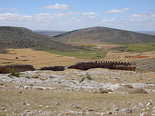 castle of Peñalcazar Historic site, Quiñonería8.2 km S
-
Sierra de Toranzos Mountain, Borobia16 km NE
-
Sierra Tablado Mountain, Borobia21 km E
-
Río Araviana River, Almenar de Soria9 km NW
-
Arroyo de la Muta River, Cueva de Ágreda19 km NE
Sources & licences
Data last updated: · 2 independent sources