Ciudad Encantada
Located in Cuenca, Province of Cuenca Coordinates: 40°12′29″ N 2°00′35″ W
- Local time
- UTC+01:00
- Europe/Madrid · UTC+01:00
- Elevation
- 1,409 m
- above sea level
- Airports
- MAD Adolfo Suárez Madrid–Barajas Airport136 km
- VLC Valencia Airport153 km
About Ciudad Encantada
Ciudad Encantada is a historic site. Location: Cuenca, Province of Cuenca. The best months to visit are June, September. The nearest airport is Adolfo Suárez Madrid–Barajas Airport (136 km). Nearby sights include Laguna de Uña and Cuenca Cathedral.
Climate of Ciudad Encantada
Best months for sightseeingBest months for sightseeing: June, September.
This month · November
A cold month
Day 10° · Night 0° · Rain 57 mm
Better nearby cities in November
- Elche · 244 km southeast20°
- Alicante · 245 km southeast20°
- Orihuela · 253 km south20°
- Hottest month
- July (day 28°)
- Coldest month
- January (night -3°)
- Wettest month
- May (65 mm)
- Driest month
- July (18 mm)
Bars: average monthly low and high temperature. Below: precipitation. Monthly averages for 1970–2000 at about 18 km resolution, adjusted for elevation. Highlighted months are mild and relatively dry. Source: WorldClim 2.1 (CC BY 4.0).
Show values as a table
| Month | Jan | Feb | Mar | Apr | May | Jun | Jul | Aug | Sep | Oct | Nov | Dec |
|---|---|---|---|---|---|---|---|---|---|---|---|---|
| Average high (°C) | 7° | 8° | 11° | 13° | 17° | 23° | 28° | 28° | 23° | 16° | 10° | 7° |
| Average low (°C) | -3° | -3° | -1° | 1° | 5° | 9° | 12° | 12° | 8° | 4° | 0° | -2° |
| Precipitation (mm) | 51 | 42 | 34 | 56 | 65 | 44 | 18 | 20 | 38 | 60 | 57 | 62 |
How to get to Ciudad Encantada
The nearest airport is Adolfo Suárez Madrid–Barajas Airport (MAD), 136 km to the west as the crow flies. The nearest large city is Alcalá de Henares, 119 km to the west.
Airports
- Adolfo Suárez Madrid–Barajas Airport (MAD) Madrid 136 kmwest
- Valencia Airport (VLC) Valencia 153 kmsoutheast
- Castellón-Costa Azahar Airport (CDT) Castellón de la Plana 177 kmeast
Nearby large cities
- Alcalá de Henares Population: 193.8K 119 kmwest
- Torrejón de Ardoz Population: 118.2K 127 kmwest
- Albacete Population: 173K 135 kmsouth
- Ciudad Lineal Population: 228.2K 142 kmwest
- Alcobendas Population: 116K 144 kmwest
Straight-line distances; road distances are longer. Airport data: OurAirports.
Day trips from Ciudad Encantada
Within 100 km: 43 historic and cultural sites, 233 natural sites, 174 lakes, rivers and coasts.
0–25 km41 places
- Laguna de Uña Lake 3 kmNE
- Pantano de La Toba Lake 8 kmE
- Sierra de Valdemeca Mountain 23 kmE
- Sierra de Tragacete Mountain 17 kmNE
25–60 km163 places
- Laguna de Navahonda Lake 51 kmW
- Laguna Grande Lake 38 kmN
- Monte de la Torre Mountain 54 kmSW
- Cerro Rubio Mountain 60 kmS
60–100 km246 places
- Pantano del Generalísimo Lake 95 kmSE
- Embalse de Alarcón Lake 69 kmS
- Laguna de Gallocanta Lake 95 kmNE
- Pantano de Entrepeñas Lake 71 kmNW
Straight-line distances.
Nearby attractions & nature
Everything nearby-
Laguna de Uña Lake, Cuenca3.4 km NE
-
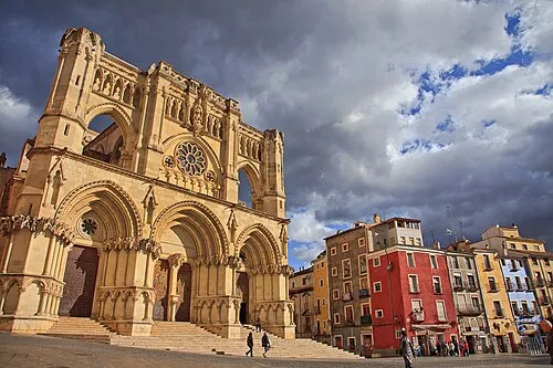 Cuenca Cathedral Attraction, Cuenca18 km SW
-
Sierra de Cuenca Mountain, Cuenca8 km E
-
Pocillo de Pedro Martínez Natural site, Cuenca8.2 km SE
-
Pantano de La Toba Lake, Cuenca8.3 km E
-
Río Villalvilla River, Cuenca6.9 km NW
-
Muralla Museum, Cuenca17 km SW
-
Museo Fundación Antonio Saura Museum, Cuenca18 km SW
Nearest towns and villages
-
Uña Village, Uña3.2 km NE
-
Uña Municipality, Province of Cuenca3.5 km NE
-
Villalba de la Sierra Municipality, Province of Cuenca6.8 km W
-
Villalba de la Sierra Village, Villalba de la Sierra7.4 km NW
Sources & licences
Data last updated: