- Elevation
- 2,163 m
- above sea level
- Local time
- UTC+01:00
- Europe/Zurich · UTC+01:00
- Airports
- BRN Bern Airport33 km
- ZRH Zürich Airport90 km
About Hohgant
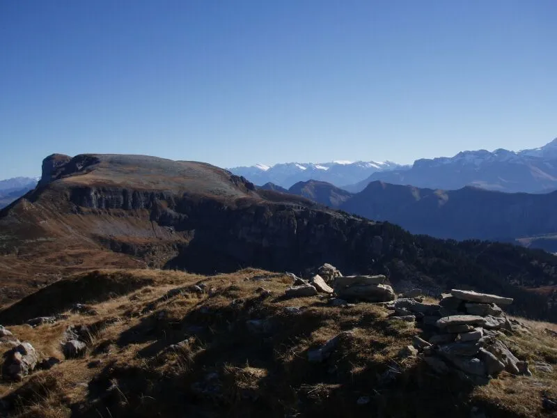
Hohgant is a mountain. Location: Schangnau, Emmental District. Elevation: 2,163 m.
The Hohgant is a mountain of the Emmental Alps, located south of the Emmental in the canton of Bern. The main summit has an elevation of 2,197 metres above sea level and is distinguished by the name Furggengütsch. Several caves (F1 and K2 networks) developing in the Urgonian limestone formation (Aptian) have their entrances on the Hohgant mountain. The F1 cave is connected to the Siebenhengste cave network.
Source: Wikipedia · CC BY-SA 4.0
At a glance
- Topographic prominence
- 638 m
Source: Wikidata
Photos of Hohgant
-

Arkelin · CC BY 4.0 -

Arkelin · CC BY 4.0 -

René Edward Knupfer-Müller · CC BY-SA 4.0 -

René Edward Knupfer-Müller · CC BY-SA 4.0 -

Lizenz: CC BY-SA 4.0 Nutzung: Download und Nutzung frei Bildnachweis: ETH-Bibliothek Zürich, Bildarchiv / Fotograf: Come · CC BY-SA 4.0


Climate of Hohgant
This month · November
A wet month
Day -1° · Night -7° · Rain 106 mm
- Hottest month
- July (day 13°)
- Coldest month
- January (night -11°)
- Wettest month
- June (132 mm)
- Driest month
- January (90 mm)
Bars: average monthly low and high temperature. Below: precipitation. Monthly averages for 1970–2000 at about 18 km resolution, adjusted for elevation. Highlighted months are mild and relatively dry. Source: WorldClim 2.1 (CC BY 4.0).
Show values as a table
| Month | Jan | Feb | Mar | Apr | May | Jun | Jul | Aug | Sep | Oct | Nov | Dec |
|---|---|---|---|---|---|---|---|---|---|---|---|---|
| Average high (°C) | -4° | -3° | -1° | 2° | 7° | 10° | 13° | 13° | 9° | 5° | -1° | -3° |
| Average low (°C) | -11° | -11° | -9° | -6° | -2° | 1° | 4° | 4° | 1° | -3° | -7° | -9° |
| Precipitation (mm) | 90 | 95 | 90 | 100 | 113 | 132 | 124 | 125 | 93 | 103 | 106 | 102 |
How to get to Hohgant
The nearest airport is Bern Airport (BRN), 33 km to the northwest as the crow flies. For international flights: Zürich Airport (ZRH) (90 km). The nearest large city is Bern, 39 km to the northwest.
Airports
- Bern Airport (BRN) Bern 33 kmnorthwest
- Zürich Airport (ZRH) Zurich 90 kmnortheast
- EuroAirport Basel–Mulhouse–Freiburg (BSL) Bâle / Mulhouse 95 kmnorth
Nearby large cities
- Bern Population: 121.6K 39 kmnorthwest
- Zurich Population: 415.4K 82 kmnortheast
- Basel Population: 177.6K 89 kmnorth
- Lausanne Population: 139.1K 101 kmwest
- Winterthur Population: 111.8K 102 kmnortheast
Straight-line distances; road distances are longer. Airport data: OurAirports.
Day trips from Hohgant
Within 100 km: 278 historic and cultural sites, 6,162 natural sites, 913 lakes, rivers and coasts.
0–25 km514 places
- Strandbad Neuhaus Beach 13 kmSW
- Strandbad Manor Farm Beach 13 kmSW
- Strandbad Leissigen Beach 17 kmSW
- Strandbad Iseltwald Beach 10 kmSE
25–60 km2,628 places
- Kleiner Bremgartenwald Mountain 41 kmNW
- Sankt-Niklausen-Insle Island 45 kmNE
- Neptun-Inseln Island 55 kmE
- Mauesee-Insel Island 45 kmN
60–100 km4,211 places
- Fahr Abbey Attraction 81 kmNE
- Arbeiterstrandbad Tennwil Beach 63 kmNE
- Lago Nero Lake 62 kmSE
- Ufenau Island 83 kmNE
Straight-line distances.
Nearest towns and villages
-
Habkern Municipality, Interlaken-Oberhasli District3.2 km S
-
Schangnau Village, Schangnau5.6 km NW
-
Bumbach Village, Schangnau3.4 km N
-
Oberried am Brienzersee Municipality, Interlaken-Oberhasli District5.6 km SE
-
Speicher Village, Habkern2.4 km S
-
Kemmeribodenbad Village, Schangnau3.6 km NE
Nearby attractions & nature
Everything nearby-
Furggegütsch Mountain, Schangnau0.7 km NE
-
Aff Mountain, Schangnau0.9 km W
-
Jurtenflue Mountain, Habkern1.7 km E
-
Stand Mountain, Habkern1.8 km S
-
Wysschrüzgrat Mountain, Schangnau2 km W
-
Höchst Mountain, Habkern2.4 km S
-
Heitbüel Mountain, Habkern2.4 km SE
-
Baumgartenflue Mountain, Habkern2.5 km E
Sources & licences
Data last updated: · 2 independent sources