Faulhorn
Located in Grindelwald, Interlaken-Oberhasli District Coordinates: 46°40′29″ N 7°59′57″ E
- Elevation
- 2,680 m
- above sea level
- Local time
- UTC+01:00
- Europe/Zurich · UTC+01:00
- Airports
- BRN Bern Airport46 km
- ZRH Zürich Airport97 km
About Faulhorn
Faulhorn is a mountain. Location: Grindelwald, Interlaken-Oberhasli District. Elevation: 2,680 m.
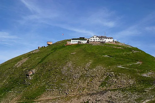
The Faulhorn is a mountain of the Bernese Alps, located between Lake Brienz and Grindelwald in the Bernese Oberland. The summit is 2,681 metres (8,796 ft) high and can be reached by several trails. The mountain is split between the municipalities of Iseltwald and Grindelwald, with the summit located on the boundary between the two. The hotel situated on the summit of Faulhorn was built in 1830. It has undergone very little change since then.
Source: Wikipedia · CC BY-SA 4.0
At a glance
- Topographic prominence
- 128 m
Source: Wikidata
Photos of Faulhorn
-

D.Wettstein & R.Sticher · Public domain -

Andrew Bossi · CC BY-SA 2.5 -

Andrew Bossi · CC BY-SA 2.5 -

Pmau · CC BY-SA 4.0 -

Alexander Blecher, blecher.info , all 452 pictures , overview · CC BY-SA 4.0


Climate of Faulhorn
This month · November
A wet month
Day -4° · Night -11° · Rain 106 mm
- Hottest month
- July (day 10°)
- Coldest month
- January (night -14°)
- Wettest month
- June (132 mm)
- Driest month
- January (90 mm)
Bars: average monthly low and high temperature. Below: precipitation. Monthly averages for 1970–2000 at about 18 km resolution, adjusted for elevation. Highlighted months are mild and relatively dry. Source: WorldClim 2.1 (CC BY 4.0).
Show values as a table
| Month | Jan | Feb | Mar | Apr | May | Jun | Jul | Aug | Sep | Oct | Nov | Dec |
|---|---|---|---|---|---|---|---|---|---|---|---|---|
| Average high (°C) | -8° | -7° | -4° | -2° | 4° | 7° | 10° | 9° | 6° | 1° | -4° | -7° |
| Average low (°C) | -14° | -14° | -12° | -10° | -5° | -2° | 0° | 0° | -3° | -6° | -11° | -13° |
| Precipitation (mm) | 90 | 95 | 90 | 100 | 113 | 132 | 124 | 125 | 93 | 103 | 106 | 102 |
How to get to Faulhorn
The nearest airport is Bern Airport (BRN), 46 km to the northwest as the crow flies. For international flights: Zürich Airport (ZRH) (97 km). The nearest large city is Bern, 52 km to the northwest.
Airports
- Bern Airport (BRN) Bern 46 kmnorthwest
- Zürich Airport (ZRH) Zurich 97 kmnortheast
- Lugano Airport (LUG) Agno 102 kmsoutheast
Nearby large cities
- Bern Population: 121.6K 52 kmnorthwest
- Zurich Population: 415.4K 88 kmnortheast
- Basel Population: 177.6K 103 kmnorth
- Lausanne Population: 139.1K 106 kmwest
- Winterthur Population: 111.8K 108 kmnortheast
Straight-line distances; road distances are longer. Airport data: OurAirports.
Day trips from Faulhorn
Within 100 km: 240 historic and cultural sites, 6,503 natural sites, 892 lakes, rivers and coasts.
0–25 km798 places
- Strandbad Neuhaus Beach 14 kmW
- Strandbad Manor Farm Beach 14 kmW
- Strandbad Leissigen Beach 18 kmW
- Strandbad Iseltwald Beach 5 kmNW
25–60 km2,975 places
- Kleiner Bremgartenwald Mountain 54 kmNW
- Lago Nero Lake 48 kmSE
- Sankt-Niklausen-Insle Island 48 kmNE
- Neptun-Inseln Island 52 kmNE
60–100 km3,862 places
- Fahr Abbey Attraction 88 kmN
- Arbeiterstrandbad Tennwil Beach 72 kmN
- Ufenau Island 85 kmNE
- Sankt Petersinsel Island 79 kmNW
Straight-line distances.
Nearest towns and villages
-
Iseltwald Municipality, Interlaken-Oberhasli District2.9 km N
-
Grindelwald Village, Grindelwald6.3 km SE
-
Bönigen Municipality, Interlaken-Oberhasli District5.8 km W
-
Lütschental Municipality, Interlaken-Oberhasli District5 km SW
-
Iseltwald Village, Iseltwald4.8 km NW
-
Gündlischwand Municipality, Interlaken-Oberhasli District5.6 km SW
Nearby attractions & nature
Everything nearby-
Gassenboden Mountain, Grindelwald0.3 km E
-
Esel Mountain, Grindelwald0.8 km SE
-
Hohtissel Mountain, Grindelwald0.9 km SW
-
Simelihorn Mountain, Grindelwald1 km SE
-
Stollen Mountain, Grindelwald1.1 km S
-
Schwabhoren Mountain, Gündlischwand1.2 km NW
-
Gassenhorn Mountain, Brienz (BE)1.2 km E
-
Reeti Mountain, Grindelwald1.5 km SE
More nature in Switzerland
-
 Schwarzhorn Mountain, Grindelwald6 km E
-
Winteregg Mountain, Grindelwald2.2 km SW
-
Ritzengrätli Mountain, Grindelwald2.6 km E
-
Hireleni Mountain, Grindelwald2.7 km SE
-
Burg Mountain, Grindelwald2.7 km SW
-
Sattelegg Mountain, Grindelwald3 km SE
Sources & licences
Data last updated: · 2 independent sources