- Elevation
- 1,443 m
- above sea level
- Local time
- UTC+01:00
- Europe/Zurich · UTC+01:00
- Airports
- ZRH Zürich Airport46 km
- BRN Bern Airport75 km
About Rigi Kaltbad
Rigi Kaltbad is a village. Location: Weggis, Lucerne-Land District. Elevation: 1,443 m. The nearest airport is Zürich Airport (46 km). Nearby sights include Rotstock and Schild.
Photos of Rigi Kaltbad
-
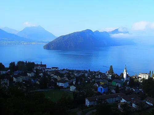
Bürgenstock Oblic · CC BY-SA 3.0

Climate of Rigi Kaltbad
This month · November
A wet month
Day 2° · Night -5° · Rain 106 mm
- Hottest month
- July (day 17°)
- Coldest month
- January (night -8°)
- Wettest month
- June (152 mm)
- Driest month
- January (82 mm)
Bars: average monthly low and high temperature. Below: precipitation. Monthly averages for 1970–2000 at about 18 km resolution, adjusted for elevation. Highlighted months are mild and relatively dry. Source: WorldClim 2.1 (CC BY 4.0).
Show values as a table
| Month | Jan | Feb | Mar | Apr | May | Jun | Jul | Aug | Sep | Oct | Nov | Dec |
|---|---|---|---|---|---|---|---|---|---|---|---|---|
| Average high (°C) | -2° | 0° | 4° | 7° | 12° | 15° | 17° | 17° | 13° | 8° | 2° | -1° |
| Average low (°C) | -8° | -7° | -5° | -2° | 2° | 5° | 7° | 7° | 4° | 0° | -5° | -7° |
| Precipitation (mm) | 82 | 92 | 88 | 101 | 119 | 152 | 148 | 146 | 104 | 101 | 106 | 95 |
How to get to Rigi Kaltbad
The nearest airport is Zürich Airport (ZRH), 46 km to the north as the crow flies. The nearest large city is Zurich, 36 km to the north.
Airports
- Zürich Airport (ZRH) Zurich 46 kmnorth
- Bern Airport (BRN) Bern 75 kmwest
- EuroAirport Basel–Mulhouse–Freiburg (BSL) Bâle / Mulhouse 94 kmnorthwest
Nearby large cities
- Zurich Population: 415.4K 36 kmnorth
- Winterthur Population: 111.8K 55 kmnorth
- Bern Population: 121.6K 78 kmwest
- Basel Population: 177.6K 88 kmnorthwest
- Freiburg im Breisgau Population: 237.5K 115 kmnorthwest
Straight-line distances; road distances are longer. Airport data: OurAirports.
Day trips from Rigi Kaltbad
Within 100 km: 409 historic and cultural sites, 5,987 natural sites, 995 lakes, rivers and coasts.
0–25 km556 places
- Insel Schwanau Island 10 kmE
- Sankt-Niklausen-Insle Island 8 kmW
- Neptun-Inseln Island 20 kmSE
- Lorzeninsel Island 15 kmN
25–60 km2,624 places
- Fahr Abbey Attraction 41 kmN
- Strandbad Iseltwald Beach 53 kmSW
- Strandbad Brienz Beach 46 kmSW
- Arbeiterstrandbad Tennwil Beach 34 kmNW
60–100 km4,211 places
- Kleiner Bremgartenwald Mountain 79 kmW
- Mainau Island 92 kmNE
- Dominikanerinsel Konstanz Island 87 kmNE
- Strandbad Steckborn Beach 78 kmNE
Straight-line distances.
Nearby attractions & nature
Everything nearby-
Rotstock Mountain, Arth0.5 km NE
-
Schild Mountain, Vitznau1.5 km SE
-
Kulm Mountain, Arth2.1 km NE
-
Schinenflue Mountain, Arth1.7 km NE
-
In den Banderen Mountain, Arth1.7 km NE
-
Stock Mountain, Küssnacht (SZ)1.9 km N
Other cities and towns in Weggis
-
Farmhütte Village, Weggis1.1 km SW
-
Romiti Village, Weggis1.1 km SE
-
 Hertenstein Village, Weggis5.1 km W
-
Remsi Village, Weggis3 km W
-
Hegi Village, Weggis4.2 km W
-
Pfaffebächeli Village, Weggis4.3 km W
Sources & licences
Data last updated: