Mont de Pro
Located in Bourg-Saint-Pierre, Entremont District Coordinates: 45°54′18″ N 7°13′17″ E
- Elevation
- 2,803 m
- above sea level
- Local time
- UTC+01:00
- Europe/Zurich · UTC+01:00
- Airports
- TRN Turin Airport85 km
- NCY Annecy Meythet airport87 km
About Mont de Pro
Mont de Pro is a mountain. Location: Bourg-Saint-Pierre, Entremont District. Elevation: 2,803 m. The nearest airport is Turin Airport (85 km). Nearby sights include Montorge and Glacier de Pieudet.
Photos of Mont de Pro
-
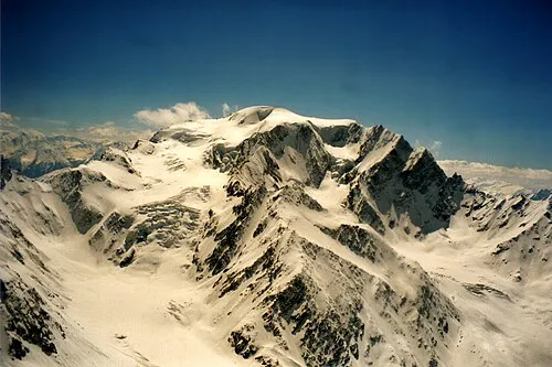
Mont Vélan Herzi Pinki · CC BY-SA 3.0

Climate of Mont de Pro
This month · November
A wet month
Day -3° · Night -8° · Rain 141 mm
- Hottest month
- August (day 10°)
- Coldest month
- February (night -12°)
- Wettest month
- November (141 mm)
- Driest month
- July (86 mm)
Bars: average monthly low and high temperature. Below: precipitation. Monthly averages for 1970–2000 at about 18 km resolution, adjusted for elevation. Highlighted months are mild and relatively dry. Source: WorldClim 2.1 (CC BY 4.0).
Show values as a table
| Month | Jan | Feb | Mar | Apr | May | Jun | Jul | Aug | Sep | Oct | Nov | Dec |
|---|---|---|---|---|---|---|---|---|---|---|---|---|
| Average high (°C) | -6° | -7° | -6° | -4° | 1° | 5° | 9° | 10° | 6° | 2° | -3° | -5° |
| Average low (°C) | -12° | -12° | -11° | -9° | -5° | -1° | 2° | 3° | 0° | -3° | -8° | -10° |
| Precipitation (mm) | 128 | 125 | 125 | 122 | 118 | 99 | 86 | 95 | 90 | 121 | 141 | 133 |
How to get to Mont de Pro
The nearest airport is Turin Airport (TRN), 85 km to the southeast as the crow flies. The nearest large city is Lausanne, 82 km to the northwest.
Airports
- Turin Airport (TRN) Caselle Torinese (TO) 85 kmsoutheast
- Annecy Meythet airport (NCY) Annecy 87 kmwest
- Geneva International Airport (GVA) Geneva 94 kmnorthwest
Nearby large cities
- Lausanne Population: 139.1K 82 kmnorthwest
- Geneva Population: 201.7K 90 kmwest
- Bern Population: 121.6K 117 kmnorth
- Grenoble Population: 158.6K 143 kmsouthwest
- Besançon Population: 128.4K 176 kmnorthwest
Straight-line distances; road distances are longer. Airport data: OurAirports.
Day trips from Mont de Pro
Within 100 km: 118 historic and cultural sites, 3,969 natural sites, 458 lakes, rivers and coasts.
0–25 km525 places
- Lac d'Orny Lake 16 kmNW
- Lac de la Breye Lake 20 kmNW
- Lac de Tsofeiret Lake 13 kmNE
- Lac du Dru Lake 20 kmNW
25–60 km1,719 places
- Stausee Mattmark Lake 59 kmE
- Lac de Fully Lake 32 kmN
- Lac de Derborence Lake 42 kmN
- Lac d'Émosson Lake 31 kmNW
60–100 km2,301 places
- Strandbad Neuhaus Beach 97 kmNE
- Strandbad Manor Farm Beach 98 kmNE
- Strandbad Leissigen Beach 94 kmNE
- Ile de Salagnon Island 65 kmNW
Straight-line distances.
Nearest towns and villages
-
Tunel Gd. St. Bernard Village, Bourg-Saint-Pierre1.8 km W
-
Bourg-Saint-Pierre Village, Bourg-Saint-Pierre5 km N
-
Grand Saint Bernard Village, Bourg-Saint-Pierre5.6 km SW
-
Liddes Municipality, Entremont District8.6 km N
-
Vaud Village, Ollomont7.7 km SE
-
Etroubles Municipality, Province of Aosta9.4 km S
Nearby attractions & nature
Everything nearby-
Montorge Mountain, Bourg-Saint-Pierre0.9 km NE
-
Glacier de Pieudet Natural site, Bourg-Saint-Pierre0.9 km E
-
Glacier de Pieudet Natural site, Bourg-Saint-Pierre1.2 km E
-
Croix de Tsousse Mountain, Bourg-Saint-Pierre1.3 km N
-
Mont Vélan Mountain, Switzerland2.8 km SE
-
Glacier de Pro Natural site, Bourg-Saint-Pierre1.4 km SE
-
Pointe de Crête Sèche Mountain, Bourg-Saint-Pierre1.8 km S
-
Bonhomme de Tsalevey Mountain, Bourg-Saint-Pierre1.9 km N
Sources & licences
Data last updated: