Çiriş
Located in Erdemli İlçesi, Mersin Province Coordinates: 36°37′34″ N 34°12′47″ E
- Population
- 1,000
- 1K
- Elevation
- 539 m
- above sea level
- Local time
- UTC+03:00
- Europe/Istanbul · UTC+03:00
About Çiriş
Çiriş is a village. Location: Erdemli İlçesi, Mersin Province. Population: 1,000. Elevation: 539 m.
Çiriş is a neighbourhood in the municipality and district of Erdemli, Mersin Province, Turkey. Its population is 1,000 (2022). It is situated to the south of the dense forestry of the Taurus Mountains. The distance to Erdemli is 12 kilometres (7.5 mi) and to Mersin is 48 kilometres (30 mi). The village was founded in a place full of ancient ruins. It was named after the Turkish name of the plant Asphodelus. The main economic activity of the village is farming.
Read more on Wikipedia Text: Wikipedia contributors · CC BY-SA 4.0 · shortened
In comparison
- No. 19 of 52 places in Erdemli İlçesi by population
- Nearest larger town: Kayacı, 3 km NW
- 4 sights and natural places within 10 km Halkalı Sarnıcı, Sandal Dağı
Nearby attractions & nature
Everything nearby-
Halkalı Sarnıcı Natural site, Mersin Province4.5 km NW
-
Sandal Dağı Mountain, Erdemli İlçesi6.6 km W
-
 Kanlıdivane Historic site, Erdemli İlçesi12 km S
-
Limonlu Çayı River, Mersin Province6.7 km SE
-
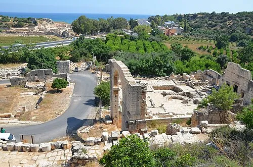 Elaiussa Sebaste Historic site, Erdemli İlçesi16 km S
-
Akkale Historic site, Erdemli İlçesi11 km S
Sources & licences
Data last updated: · 2 independent sources