- Elevation
- 653 m
- above sea level
- Local time
- UTC+00:00
- Europe/London · UTC+00:00
- Airports
- IOM Isle of Man Airport99 km
- MME Teesside International Airport116 km
About Harter Fell (Eskdale)
Harter Fell (Eskdale) is a mountain. Location: Ulpha, Cumberland. Elevation: 653 m.
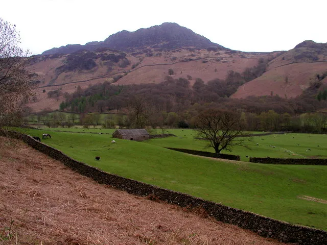
Harter Fell is a fell in the western part of the English Lake District, located between the Eskdale and Duddon valleys. Its height is 653 metres (2,142 ft) There are several walking routes to the summit.
Source: Wikipedia · CC BY-SA 4.0
Photos of Harter Fell (Eskdale)
-

Director General of the Ordnance Survey, UK · Public domain -

Michael Graham · CC BY-SA 2.0 -

Michael Graham · CC BY-SA 2.0 -

Peter S · CC BY-SA 2.0 -

Wikimedia Commons · CC BY-SA 2.0


Climate of Harter Fell (Eskdale)
This month · November
A wet month
Day 5° · Night 0° · Rain 185 mm
- Hottest month
- July (day 15°)
- Coldest month
- January (night -3°)
- Wettest month
- December (192 mm)
- Driest month
- June (96 mm)
Bars: average monthly low and high temperature. Below: precipitation. Monthly averages for 1970–2000 at about 18 km resolution, adjusted for elevation. Highlighted months are mild and relatively dry. Source: WorldClim 2.1 (CC BY 4.0).
Show values as a table
| Month | Jan | Feb | Mar | Apr | May | Jun | Jul | Aug | Sep | Oct | Nov | Dec |
|---|---|---|---|---|---|---|---|---|---|---|---|---|
| Average high (°C) | 2° | 3° | 5° | 8° | 11° | 14° | 15° | 15° | 12° | 9° | 5° | 3° |
| Average low (°C) | -3° | -2° | -1° | 0° | 3° | 6° | 8° | 7° | 5° | 3° | 0° | -2° |
| Precipitation (mm) | 189 | 136 | 149 | 104 | 98 | 96 | 104 | 127 | 145 | 189 | 185 | 192 |
How to get to Harter Fell (Eskdale)
The nearest airport is Isle of Man Airport (IOM), 99 km to the west as the crow flies. The nearest large city is Blackpool, 64 km to the south.
Airports
- Isle of Man Airport (IOM) Castletown, Rushen 99 kmwest
- Teesside International Airport (MME) Darlington, Durham 116 kmeast
- Leeds Bradford Airport (LBA) Leeds, West Yorkshire 116 kmsoutheast
Nearby large cities
- Blackpool Population: 145K 64 kmsouth
- Preston Population: 313.3K 77 kmsoutheast
- Blackburn Population: 146.5K 85 kmsoutheast
- Burnley Population: 149.4K 91 kmsoutheast
- Wigan Population: 175.4K 101 kmsouth
Straight-line distances; road distances are longer. Airport data: OurAirports.
Day trips from Harter Fell (Eskdale)
Within 100 km: 580 historic and cultural sites, 1,946 natural sites, 391 lakes, rivers and coasts.
0–25 km738 places
- High Moor Mountain 19 kmS
- Tuft Rock Island 18 kmE
- Peel Island Island 11 kmSE
- Seamew Crag Island 15 kmE
25–60 km838 places
- Roanhead Beach Beach 25 kmS
- St. Bees Beach Seafront Beach 28 kmNW
- Walney Island Island 31 kmS
- Foulney Island Island 38 kmS
60–100 km1,341 places
- British Isles Island 67 kmSW
- Great Britain Island 90 kmSE
- Formby Beach Beach 92 kmS
- Ainsdale Beach Beach 87 kmS
Straight-line distances.
Nearest towns and villages
-
Eskdale Village, Cumberland3.9 km NW
-
Cockley Beck Village, Dunnerdale-with-Seathwaite3.4 km NE
-
Dunnerdale-with-Seathwaite Village, Westmorland and Furness4.1 km SE
-
Seathwaite Village, Dunnerdale-with-Seathwaite3.9 km S
-
Boot Village, Eskdale4.3 km W
-
Beckfoot Village, Eskdale5.1 km W
Nearby attractions & nature
Everything nearby-
Demming Crag Mountain, Ulpha0.6 km NE
-
Horsehow Crags Mountain, Eskdale1.2 km NE
-
Peathill Crag South Top Mountain, Eskdale1.7 km NE
-
Peathill Crag Mountain, Eskdale1.9 km NE
-
Long Crag Mountain, Dunnerdale-with-Seathwaite2 km E
-
Kepple Crag Mountain, Eskdale2 km W
-
Crook Crag Mountain, Eskdale2.1 km SW
-
Great Whinscale Mountain, Eskdale2.2 km W
More nature in United Kingdom
-
 Little Stand Mountain, Ulpha4.8 km NE
-
Green Crag Mountain, Ulpha2.4 km SW
-
Wallowbarrow Heald Mountain, Ulpha2.5 km S
-
Hesk Fell Mountain, Ulpha6.6 km SW
-
Birker Fell - White How Mountain, Ulpha2.7 km SW
-
Iron Crag Mountain, Ulpha2.7 km S
Sources & licences
Data last updated: · 2 independent sources