Moor House Nature Reserve
Located in England, United Kingdom Coordinates: 54°41′00″ N 2°22′00″ W
- Elevation
- 584 m
- above sea level
- Local time
- UTC+00:00
- Europe/London · UTC+00:00
- Airports
- NCL Newcastle International Airport59 km
- MME Teesside International Airport64 km
About Moor House Nature Reserve
Moor House Nature Reserve is a natural site. Location: England, United Kingdom. The best months to visit are July. The nearest airport is Newcastle International Airport (59 km). Nearby sights include Viewing Hill and Bellbeaver Rigg.
Photos of Moor House Nature Reserve
-

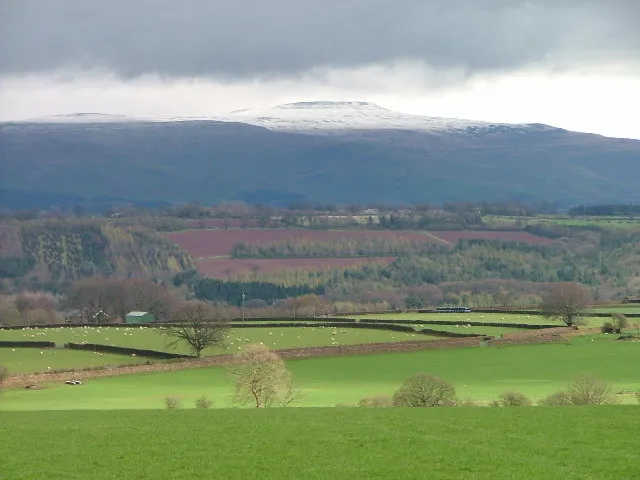
Great Dun Fell Andy Stephenson · CC BY-SA 2.0

Climate of Moor House Nature Reserve
Best months for sightseeingBest months for sightseeing: July.
This month · November
A wet month
Day 6° · Night 1° · Rain 171 mm
- Hottest month
- July (day 17°)
- Coldest month
- January (night -2°)
- Wettest month
- January (181 mm)
- Driest month
- June (92 mm)
Bars: average monthly low and high temperature. Below: precipitation. Monthly averages for 1970–2000 at about 18 km resolution, adjusted for elevation. Highlighted months are mild and relatively dry. Source: WorldClim 2.1 (CC BY 4.0).
Show values as a table
| Month | Jan | Feb | Mar | Apr | May | Jun | Jul | Aug | Sep | Oct | Nov | Dec |
|---|---|---|---|---|---|---|---|---|---|---|---|---|
| Average high (°C) | 3° | 3° | 5° | 8° | 12° | 15° | 17° | 16° | 13° | 10° | 6° | 4° |
| Average low (°C) | -2° | -2° | -1° | 0° | 3° | 6° | 8° | 8° | 6° | 3° | 1° | -1° |
| Precipitation (mm) | 181 | 127 | 142 | 96 | 94 | 92 | 103 | 120 | 134 | 163 | 171 | 177 |
Other places to visit in this season: July
How to get to Moor House Nature Reserve
The nearest airport is Newcastle International Airport (NCL), 59 km to the northeast as the crow flies. The nearest large city is Newcastle upon Tyne, 58 km to the northeast.
Airports
- Newcastle International Airport (NCL) Newcastle upon Tyne, Tyne and Wear 59 kmnortheast
- Teesside International Airport (MME) Darlington, Durham 64 kmeast
- Leeds Bradford Airport (LBA) Leeds, West Yorkshire 102 kmsoutheast
Nearby large cities
- Newcastle upon Tyne Population: 300.1K 58 kmnortheast
- Sunderland Population: 170.1K 68 kmeast
- Middlesbrough Population: 142.7K 74 kmeast
- Burnley Population: 149.4K 99 kmsouth
- Blackburn Population: 146.5K 104 kmsouth
Straight-line distances; road distances are longer. Airport data: OurAirports.
Day trips from Moor House Nature Reserve
Within 100 km: 827 historic and cultural sites, 2,266 natural sites, 412 lakes, rivers and coasts.
0–25 km183 places
- Grassholme Reservoir Lake 20 kmSE
- Selset Reservoir Lake 18 kmSE
- Three Pikes Mountain 7 kmE
- Mickle Fell Mountain 10 kmSE
25–60 km1,389 places
- Tuft Rock Island 50 kmSW
- Batt Island Island 52 kmSE
- Michell's Island Island 45 kmE
- Wood Howe Island 35 kmSW
60–100 km1,933 places
- Great Britain Island 80 kmS
- High Moor Mountain 72 kmSW
- Roanhead Beach Beach 82 kmSW
- St. Bees Beach Seafront Beach 83 kmW
Straight-line distances.
Nearest towns and villages
-
Dufton Village, Westmorland and Furness4.2 km SW
-
Milburn Village, Westmorland and Furness6.5 km W
-
Harwood Village, Forest and Frith6.4 km E
-
Forest and Frith Municipality, Durham7.3 km E
-
Langdon Beck Village, Forest and Frith8.9 km E
-
Long Marton Village, Westmorland and Furness9.8 km SW
Nearby attractions & nature
Everything nearby-
Viewing Hill Mountain, Forest and Frith2.7 km NE
-
Bellbeaver Rigg Mountain, Alston Moor3 km N
-
Meldon Hill Mountain, Dufton3.1 km S
-
Great Dun Fell Mountain, Milburn5.5 km W
-
Round Hill Mountain, Alston Moor4.5 km NW
-
Knock Fell Mountain, Dufton4.7 km SW
-
Harwood Common Mountain, Forest and Frith5.2 km NE
-
 Cross Fell Mountain, Culgaith8 km W
Sources & licences
Data last updated: