- Elevation
- 668 m
- above sea level
- Local time
- UTC+00:00
- Europe/London · UTC+00:00
- Airports
- LBA Leeds Bradford Airport47 km
- MME Teesside International Airport65 km
About Fountains Fell
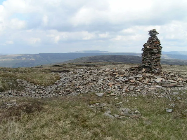
Fountains Fell is a mountain. Location: Malham Moor, Craven District. Elevation: 668 m.
Fountains Fell is a mountain in the Yorkshire Dales, England. The main summit (SD864716) has a height of 668 metres (2,192 ft) and a relative height or topographic prominence of 243 metres (797 ft) and thus qualifies as a Marilyn. Its subsidiary, Fountains Fell South Top (SD868708) reaches 662 metres (2,172 ft) and qualifies as a Nuttall. A third summit, further south at SD868697, reaches 610 metres (2,001 ft) and is the most southerly 2,000 ft summit in the Pennines north of the Peak District.
Source: Wikipedia · CC BY-SA 4.0
At a glance
- Topographic prominence
- 243 m
Source: Wikidata
Photos of Fountains Fell
-

Director General of the Ordnance Survey, UK · Public domain -

Chris Heaton · CC BY-SA 2.0 -

Chris Heaton · CC BY-SA 2.0 -

John H Darch · CC BY-SA 2.0 -

Bill Boaden · CC BY-SA 2.0


Climate of Fountains Fell
This month · November
A wet month
Day 5° · Night 0° · Rain 161 mm
- Hottest month
- July (day 16°)
- Coldest month
- January (night -2°)
- Wettest month
- December (162 mm)
- Driest month
- May (85 mm)
Bars: average monthly low and high temperature. Below: precipitation. Monthly averages for 1970–2000 at about 18 km resolution, adjusted for elevation. Highlighted months are mild and relatively dry. Source: WorldClim 2.1 (CC BY 4.0).
Show values as a table
| Month | Jan | Feb | Mar | Apr | May | Jun | Jul | Aug | Sep | Oct | Nov | Dec |
|---|---|---|---|---|---|---|---|---|---|---|---|---|
| Average high (°C) | 3° | 3° | 5° | 8° | 11° | 14° | 16° | 16° | 13° | 9° | 5° | 3° |
| Average low (°C) | -2° | -2° | -1° | 0° | 3° | 6° | 8° | 8° | 6° | 3° | 0° | -1° |
| Precipitation (mm) | 157 | 105 | 126 | 89 | 85 | 93 | 99 | 121 | 130 | 153 | 161 | 162 |
How to get to Fountains Fell
The nearest airport is Leeds Bradford Airport (LBA), 47 km to the southeast as the crow flies. The nearest large city is Burnley, 38 km to the south.
Airports
- Leeds Bradford Airport (LBA) Leeds, West Yorkshire 47 kmsoutheast
- Teesside International Airport (MME) Darlington, Durham 65 kmnortheast
- Manchester Airport (MAN) Manchester, Greater Manchester 88 kmsouth
Nearby large cities
- Burnley Population: 149.4K 38 kmsouth
- Blackburn Population: 146.5K 47 kmsouthwest
- Bradford Population: 366.2K 49 kmsoutheast
- Preston Population: 313.3K 53 kmsouthwest
- Leeds Population: 536.3K 58 kmsoutheast
Straight-line distances; road distances are longer. Airport data: OurAirports.
Day trips from Fountains Fell
Within 100 km: 811 historic and cultural sites, 1,864 natural sites, 303 lakes, rivers and coasts.
0–25 km158 places
- Great Britain Island 21 kmSE
- Bird Island Island 21 kmSW
- Mill Island Island 22 kmSE
- Semer Water Lake 15 kmNE
25–60 km995 places
- The Island Island 38 kmE
- Tuft Rock Island 53 kmNW
- The Island Island 49 kmE
- Batt Island Island 27 kmNE
60–100 km1,825 places
- High Moor Mountain 61 kmW
- Formby Beach Beach 87 kmSW
- Ainsdale Beach Beach 82 kmSW
- St Anne's Beach Beach 70 kmSW
Straight-line distances.
Nearest towns and villages
-
Halton Gill Village, Craven District3.6 km N
-
Brackenbottom Village, Horton in Ribblesdale4.8 km W
-
Stainforth Village, Craven District4.8 km SW
-
Litton Village, Craven District4.9 km NE
-
Settle Village, Settle9.1 km SW
-
Litton Village, Litton5.1 km E
Nearby attractions & nature
Everything nearby-
Fountains Fell South Top Mountain, Malham Moor0.9 km SE
-
Darnbrook Fell Mountain, Litton2.4 km NE
-
Pen-y-ghent Mountain, Halton Gill3.1 km NW
-
Plover Hill Mountain, Halton Gill3.9 km NW
-
Pennine Chain Mountain, England4.1 km NE
-
Black Hill Mountain, Malham Moor5.4 km S
-
Blaydike Moss Mountain, Halton Gill5.8 km N
-
Height Mountain, Malham Moor5.8 km SE
Sources & licences
Data last updated: · 2 independent sources