Farnham
Located in Waverley District, Surrey Coordinates: 51°12′37″ N 0°47′43″ W
- Elevation
- 79 m
- above sea level
- Local time
- UTC+00:00
- Europe/London · UTC+00:00
- Places inside
- 23
- listed under Farnham
About Farnham
Farnham is a village. Location: Waverley District, Surrey. Elevation: 79 m.
In comparison
- Nearest larger town: Farnham, 1 km NW
- 24 sights and natural places within 10 km The Farnum Museum, Farnham Castle
- Listed here: Village: 9, Neighbourhood: 7, Historic site: 1, Landmark: 1
Places in Farnham
23 places-
Farnham Town37K
-
Hale Neighbourhood15.7K
-
Compton Neighbourhood3.1K
-
Badshot Lea Village
-
Boundstone Village
-
Bricksbury Hill Mountain
-
Dippenhall Village
-
Farnham Castle Historic site
-
Heath End Neighbourhood
-
Hog Hatch Village
-
Lower Bourne Neighbourhood
-
Lower Hale Neighbourhood
-
Middle Bourne Neighbourhood
-
Moor Park Natural site
-
Runfold Village
-
Shortheath Village
-
The Bourne Neighbourhood
-
The Bourne Stream River
-
The Farnum Museum Museum
-
Upper Hale Village
-
Upper Hale Radio Tower Landmark
-
Weybourne Village
-
Wrecclesham Village
Nearby attractions & nature
Everything nearby-
Waverley Abbey Historic site, Tilford2.3 km SE
-
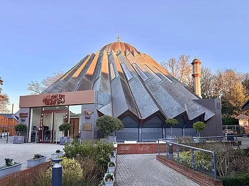 Mubarak Mosque Attraction, Tilford3.8 km SE
-
 Recreation Ground Landmark, Rushmoor District5.1 km NE
-
Crooksbury Hill Mountain, Tilford3.6 km E
-
Barley Pound Historic site, Crondall4.6 km W
-
All Saints' Church of England (C of E) Attraction, Tilford4.4 km SE
Sources & licences
Data last updated: