Carn Neill
Located in Causeway Coast and Glens, Northern Ireland Coordinates: 55°02′30″ N 6°02′40″ W
- Elevation
- 396 m
- above sea level
- Local time
- UTC+00:00
- Europe/London · UTC+00:00
- Airports
- BFS Belfast International Airport44 km
- BHD George Best Belfast City Airport48 km
About Carn Neill
Carn Neill is a mountain. Location: Causeway Coast and Glens, Northern Ireland. Elevation: 396 m. The best months to visit are July. The nearest airport is Belfast International Airport (44 km). Nearby sights include Lurigethan and Knockore.
Photos of Carn Neill
-
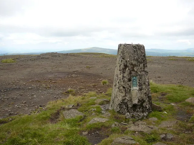
Trostan Colin Park · CC BY-SA 2.0

Climate of Carn Neill
Best months for sightseeingBest months for sightseeing: July.
This month · November
A wet month
Day 8° · Night 3° · Rain 133 mm
- Hottest month
- July (day 16°)
- Coldest month
- January (night 1°)
- Wettest month
- January (138 mm)
- Driest month
- May (64 mm)
Bars: average monthly low and high temperature. Below: precipitation. Monthly averages for 1970–2000 at about 18 km resolution, adjusted for elevation. Highlighted months are mild and relatively dry. Source: WorldClim 2.1 (CC BY 4.0).
Show values as a table
| Month | Jan | Feb | Mar | Apr | May | Jun | Jul | Aug | Sep | Oct | Nov | Dec |
|---|---|---|---|---|---|---|---|---|---|---|---|---|
| Average high (°C) | 5° | 5° | 7° | 9° | 12° | 14° | 16° | 16° | 14° | 11° | 8° | 6° |
| Average low (°C) | 1° | 1° | 1° | 2° | 5° | 7° | 9° | 9° | 8° | 5° | 3° | 1° |
| Precipitation (mm) | 138 | 99 | 110 | 74 | 64 | 66 | 79 | 90 | 108 | 131 | 133 | 131 |
Other places to visit in this season: July
How to get to Carn Neill
The nearest airport is Belfast International Airport (BFS), 44 km to the south as the crow flies. The nearest large city is Belfast, 50 km to the south.
Airports
- Belfast International Airport (BFS) Belfast 44 kmsouth
- George Best Belfast City Airport (BHD) Belfast 48 kmsouth
- Campbeltown Airport (CAL) Campbeltown 50 kmnortheast
Nearby large cities
- Belfast Population: 348K 50 kmsouth
- Glasgow Population: 626.4K 146 kmnortheast
- Dublin Population: 1M 191 kmsouth
- Edinburgh Population: 515K 207 kmnortheast
- Blackpool Population: 145K 237 kmsoutheast
Straight-line distances; road distances are longer. Airport data: OurAirports.
Day trips from Carn Neill
Within 100 km: 90 historic and cultural sites, 960 natural sites, 444 lakes, rivers and coasts.
0–25 km55 places
- West Maiden Island 23 kmSE
- East Maiden Island 24 kmSE
- Slemish Mountain Mountain 18 kmS
- Path Head Mountain 13 kmSE
25–60 km249 places
- Portstewart Beach Beach 46 kmW
- Benone Beach Beach 55 kmW
- Portstewart Strand Beach 48 kmW
- The Skerries Island 42 kmNW
60–100 km1,190 places
- Isle of Arran Island 80 kmNE
- Lisfannon Beach Beach 92 kmW
- Texa Island Island 64 kmN
- Reedy Flat Island 65 kmSW
Straight-line distances.
Nearest towns and villages
-
Glenariff Village, Causeway Coast and Glens1.7 km NW
-
Cushendall Village, Causeway Coast and Glens4.5 km N
-
Carnlough Village, Mid and East Antrim6.5 km SE
-
Knocknacarry Village, Causeway Coast and Glens8.4 km N
-
Rock Port Village, Causeway Coast and Glens8.4 km N
-
Cushendun Village, Causeway Coast and Glens9.7 km N
Nearby attractions & nature
Everything nearby-
Lurigethan Mountain, Causeway Coast and Glens2.7 km W
-
Knockore Mountain, Mid and East Antrim3 km E
-
Glenariff River River, Northern Ireland1.7 km NW
-
Red Bay Natural site, Causeway Coast and Glens2.4 km N
-
Little Trosk Mountain, Mid and East Antrim4.1 km S
-
Glenaan River River, Northern Ireland3.1 km NW
-
Crockalough Mountain, Causeway Coast and Glens4.4 km W
-
Trostan Mountain, Causeway Coast and Glens7.9 km W
Sources & licences
Data last updated: · 2 independent sources