- Local time
- UTC+00:00
- Europe/London · UTC+00:00
- Airports
- TRE Tiree Airport35 km
- ILY Islay Airport68 km
About Soa Island
Soa Island is an island. Location: Argyll and Bute, Scotland. The best months to visit are July. The nearest airport is Tiree Airport (35 km). Nearby sights include Soa Island NE Top and Eilean Musimul.
Photos of Soa Island
-
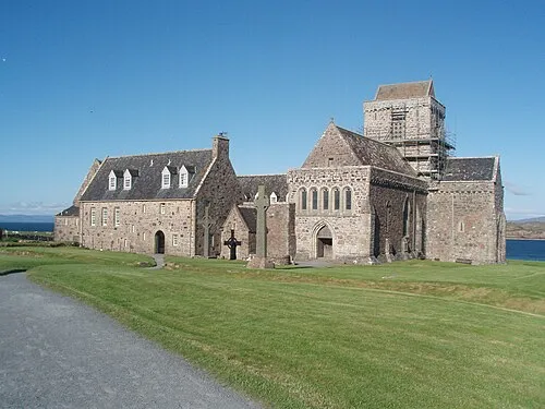
Iona Abbey Akela NDE · CC BY-SA 2.0 fr

Climate of Soa Island
Best months for sightseeingBest months for sightseeing: July.
This month · November
A wet month
Day 10° · Night 6° · Rain 184 mm
- Hottest month
- August (day 17°)
- Coldest month
- February (night 4°)
- Wettest month
- January (196 mm)
- Driest month
- May (67 mm)
Bars: average monthly low and high temperature. Below: precipitation. Monthly averages for 1970–2000 at about 18 km resolution, adjusted for elevation. Highlighted months are mild and relatively dry. Source: WorldClim 2.1 (CC BY 4.0).
Show values as a table
| Month | Jan | Feb | Mar | Apr | May | Jun | Jul | Aug | Sep | Oct | Nov | Dec |
|---|---|---|---|---|---|---|---|---|---|---|---|---|
| Average high (°C) | 8° | 8° | 9° | 10° | 13° | 15° | 17° | 17° | 15° | 12° | 10° | 8° |
| Average low (°C) | 4° | 4° | 5° | 6° | 8° | 10° | 12° | 12° | 11° | 9° | 6° | 5° |
| Precipitation (mm) | 196 | 121 | 144 | 87 | 67 | 77 | 100 | 122 | 160 | 180 | 184 | 177 |
Other places to visit in this season: July
How to get to Soa Island
The nearest airport is Tiree Airport (TRE), 35 km to the northwest as the crow flies. The nearest large city is Glasgow, 144 km to the east.
Airports
- Tiree Airport (TRE) Balemartine, Argyll and Bute 35 kmnorthwest
- Islay Airport (ILY) Isle of Islay, Argyll and Bute 68 kmsouth
- Barra Airport (BRR) Eoligarry 102 kmnorthwest
Nearby large cities
- Glasgow Population: 626.4K 144 kmeast
- Belfast Population: 348K 191 kmsouth
- Edinburgh Population: 515K 206 kmeast
- Dundee Population: 148.2K 216 kmeast
- Aberdeen Population: 198.6K 283 kmeast
Straight-line distances; road distances are longer. Airport data: OurAirports.
Day trips from Soa Island
Within 100 km: 29 historic and cultural sites, 1,972 natural sites, 1,052 lakes, rivers and coasts.
0–25 km122 places
- Treshnish Isles Island 24 kmN
- Rèidh Eilean Island 7 kmN
- Mâisgeir Island 22 kmNE
- Lunga Island 23 kmN
25–60 km950 places
- Colonsay Island 28 kmSE
- Kiloran Beach Beach 26 kmSE
- Scarba Island 47 kmE
- Oronsay Island 53 kmNE
60–100 km1,981 places
- Hebrides Island 80 kmN
- Eigg Island 71 kmN
- Eriska Island 70 kmNE
- Garbh-Lingeigh Island 98 kmNW
Straight-line distances.
Nearest towns and villages
-
Isle of Iona Village, Argyll and Bute5.8 km N
-
Fionnphort Village, Argyll and Bute7 km NE
-
Ruanaich Village, Argyll and Bute5.3 km NE
-
Fidden Village, Argyll and Bute6 km NE
-
Baile Mor Village, Argyll and Bute6.3 km NE
-
Aridhglas Village, Argyll and Bute8.3 km NE
Nearby attractions & nature
Everything nearby-
Soa Island NE Top Mountain, Argyll and Bute0.4 km NW
-
Eilean Musimul Island, Argyll and Bute2.8 km N
-
Druim an Aoineidh Mountain, Argyll and Bute3.5 km N
-
Stac an Aoineidh Island, Argyll and Bute3.7 km N
-
Eilean nan Muc Island, Argyll and Bute3.6 km E
-
Eilean Maol Mhàrtuin Island, Argyll and Bute3.9 km N
-
Rubha Calachain Mountain, Argyll and Bute4.4 km E
-
Cnoc Druidean Mountain, Argyll and Bute4.5 km NE
Sources & licences
Data last updated: