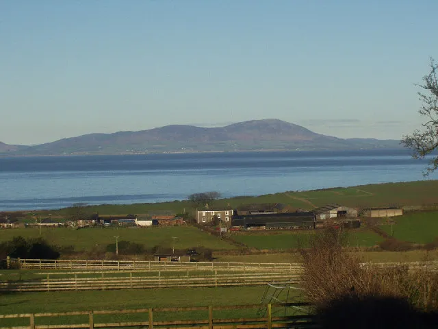
- Elevation
- 569 m
- above sea level
- Local time
- UTC+00:00
- Europe/London · UTC+00:00
- Airports
- PIK Glasgow Prestwick Airport87 km
- EDI Edinburgh Airport114 km
About Criffel
Criffel is a mountain. Location: Dumfries and Galloway, Scotland. Elevation: 569 m.
Criffel is a hill in the historical county of Kirkcudbrightshire, Dumfries and Galloway, south-west Scotland. It is 570 m (1,870 ft) high but appears higher because of its great isolation and high prominence. It is a prominent feature in many of the views from the northern Lake District on a clear day. It is surrounded by a host of satellites, including Long Fell, Maidenpap and Bainloch Hill. The slopes of Criffel feature the upland vegetation of heather, bog cotton and blaeberry and are inhabited by skylarks.
Source: Wikipedia · CC BY-SA 4.0
At a glance
- Topographic prominence
- 488 m
Source: Wikidata
Photos of Criffel
-

James Johnstone from Ecclefechan, Scotland · CC BY 2.0 -

Anthony Foster · CC BY-SA 2.0 -

caroline legg · CC BY 2.0 -

Rept0n1x · CC BY-SA 3.0 -

David Brown · CC BY-SA 2.0


Climate of Criffel
Best months for sightseeingBest months for sightseeing: July.
This month · November
A wet month
Day 6° · Night 0° · Rain 121 mm
- Hottest month
- July (day 15°)
- Coldest month
- January (night -2°)
- Wettest month
- January (130 mm)
- Driest month
- April (62 mm)
Bars: average monthly low and high temperature. Below: precipitation. Monthly averages for 1970–2000 at about 18 km resolution, adjusted for elevation. Highlighted months are mild and relatively dry. Source: WorldClim 2.1 (CC BY 4.0).
Show values as a table
| Month | Jan | Feb | Mar | Apr | May | Jun | Jul | Aug | Sep | Oct | Nov | Dec |
|---|---|---|---|---|---|---|---|---|---|---|---|---|
| Average high (°C) | 3° | 4° | 5° | 8° | 11° | 14° | 15° | 15° | 12° | 9° | 6° | 4° |
| Average low (°C) | -2° | -2° | -1° | 1° | 3° | 6° | 8° | 8° | 6° | 3° | 0° | -1° |
| Precipitation (mm) | 130 | 95 | 97 | 62 | 68 | 64 | 74 | 86 | 95 | 128 | 121 | 128 |
Other places to visit in this season: July
How to get to Criffel
The nearest airport is Glasgow Prestwick Airport (PIK), 87 km to the northwest as the crow flies. The nearest large city is Glasgow, 110 km to the north.
Airports
- Glasgow Prestwick Airport (PIK) Prestwick, South Ayrshire 87 kmnorthwest
- Edinburgh Airport (EDI) Ingliston, Edinburgh 114 kmnorth
- Isle of Man Airport (IOM) Castletown, Rushen 115 kmsouthwest
Nearby large cities
- Glasgow Population: 626.4K 110 kmnorth
- Edinburgh Population: 515K 116 kmnorth
- Newcastle upon Tyne Population: 300.1K 129 kmeast
- Blackpool Population: 145K 131 kmsouth
- Sunderland Population: 170.1K 144 kmeast
Straight-line distances; road distances are longer. Airport data: OurAirports.
Day trips from Criffel
Within 100 km: 432 historic and cultural sites, 3,030 natural sites, 694 lakes, rivers and coasts.
0–25 km232 places
- Powillimount Beach Beach 6 kmSE
- Hestan Island Island 17 kmSW
- Cottage Island Island 21 kmNE
- Dormont Island Island 21 kmNE
25–60 km1,552 places
- St. Bees Beach Seafront Beach 50 kmS
- Murrays Isles Island 41 kmW
- Islands of Fleet Island 41 kmW
- Ardwall Isle Island 41 kmW
60–100 km2,372 places
- High Moor Mountain 87 kmS
- Roanhead Beach Beach 90 kmS
- Ayr Beach Beach 87 kmNW
- Troon Beach Beach 94 kmNW
Straight-line distances.
Nearest towns and villages
-
 Kirkbean Village, Dumfries and Galloway3.4 km SE
-
Overton Village, Dumfries and Galloway3.4 km NE
-
Carsethorn Village, Dumfries and Galloway4.1 km SE
-
Prestonmill Village, Dumfries and Galloway4.3 km S
-
New Abbey Village, Dumfries and Galloway4.4 km N
-
Southerness Village, Dumfries and Galloway7.6 km S
Nearby attractions & nature
Everything nearby-
Boreland Hill Mountain, Dumfries and Galloway1.7 km SW
-
Loch Kindar Lake, Scotland1.3 km NE
-
Glen Craig Mountain, Dumfries and Galloway3.2 km N
-
Loch Hill Mountain, Dumfries and Galloway3.3 km NE
-
Drum Bay Natural site, Dumfries and Galloway2.8 km E
-
Redbank Hill Mountain, Dumfries and Galloway3.6 km SW
-
Carse Bay Natural site, Dumfries and Galloway3.5 km SE
-
Doon Hill Mountain, Dumfries and Galloway4.5 km SW
Sources & licences
Data last updated: · 2 independent sources