- Elevation
- 256 m
- above sea level
- Local time
- UTC+00:00
- Europe/London · UTC+00:00
- Airports
- INV Inverness Airport44 km
- SYY Stornoway Airport129 km
About Creag a' Ghoirtein
Creag a' Ghoirtein is a mountain. Location: Highland, Scotland. Elevation: 256 m. The best months to visit are July. The nearest airport is Inverness Airport (44 km). Nearby sights include Cnoc Pollcherian and Carn Ban.
Photos of Creag a' Ghoirtein
-
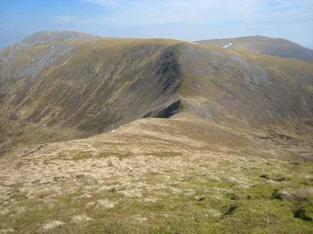
Sgurr na Ruaidhe Stuart Meek · CC BY-SA 2.0

Climate of Creag a' Ghoirtein
Best months for sightseeingBest months for sightseeing: July.
This month · November
A wet month
Day 8° · Night 2° · Rain 258 mm
- Hottest month
- July (day 17°)
- Coldest month
- February (night 0°)
- Wettest month
- January (274 mm)
- Driest month
- May (108 mm)
Bars: average monthly low and high temperature. Below: precipitation. Monthly averages for 1970–2000 at about 18 km resolution, adjusted for elevation. Highlighted months are mild and relatively dry. Source: WorldClim 2.1 (CC BY 4.0).
Show values as a table
| Month | Jan | Feb | Mar | Apr | May | Jun | Jul | Aug | Sep | Oct | Nov | Dec |
|---|---|---|---|---|---|---|---|---|---|---|---|---|
| Average high (°C) | 6° | 6° | 7° | 10° | 13° | 16° | 17° | 17° | 14° | 11° | 8° | 6° |
| Average low (°C) | 0° | 0° | 1° | 2° | 5° | 7° | 9° | 9° | 7° | 5° | 2° | 0° |
| Precipitation (mm) | 274 | 185 | 222 | 116 | 108 | 114 | 122 | 146 | 209 | 240 | 258 | 262 |
Other places to visit in this season: July
How to get to Creag a' Ghoirtein
The nearest airport is Inverness Airport (INV), 44 km to the east as the crow flies. The nearest large city is Dundee, 151 km to the southeast.
Airports
- Inverness Airport (INV) Inverness, Highland 44 kmeast
- Stornoway Airport (SYY) Stornoway, Western Isles 129 kmnorthwest
- Dundee Airport (DND) Dundee 150 kmsoutheast
Nearby large cities
- Dundee Population: 148.2K 151 kmsoutheast
- Aberdeen Population: 198.6K 162 kmeast
- Glasgow Population: 626.4K 176 kmsouth
- Edinburgh Population: 515K 189 kmsoutheast
- Belfast Population: 348K 323 kmsouth
Straight-line distances; road distances are longer. Airport data: OurAirports.
Day trips from Creag a' Ghoirtein
Within 100 km: 44 historic and cultural sites, 4,559 natural sites, 989 lakes, rivers and coasts.
0–25 km426 places
- Moy Island Island 20 kmNE
- Eilean Aigas Island 11 kmE
- Eilean nan Uan Island 19 kmNE
- Eilean an Daraich Island 21 kmN
25–60 km1,872 places
- Eilean Sùbhainn Island 54 kmNW
- Eilean Ruairidh Mòr Island 56 kmNW
- Eilean Donan Island 50 kmW
- An Garbh-eilean Island 55 kmW
60–100 km3,294 places
- Isle of Skye Island 92 kmW
- Island of Raasay Island 80 kmW
- Findlays Seat Mountain 94 kmE
- Lossiemouth East Beach Beach 93 kmE
Straight-line distances.
Nearest towns and villages

Nearby attractions & nature
Everything nearby-
Cnoc Pollcherian Mountain, Highland2.1 km W
-
Carn Ban Mountain, Highland2.5 km NW
-
Tom Ruigh na Beiste Mountain, Highland2.5 km SW
-
Carn nam Barran Mountain, Highland3 km S
-
Carn Moraig Mountain, Highland3.2 km S
-
Neaty Burn River, Highland1.6 km SE
-
Beinn a' Bha' ach Ard Mountain, Highland3.3 km N
-
Creag Liath Mountain, Highland3.8 km NE
More nature in United Kingdom
-
Sgurr na Ruaidhe Mountain, Highland7 km W
-
Carn a' Mhuilt Mountain, Highland3.9 km S
-
Carn nan Gearran Bana Mountain, Highland4.5 km NW
-
Sgurr a' Phollain Mountain, Highland4.7 km N
-
Meallan Buidhe Mountain, Highland4.8 km NW
-
Carn an Sgoltaidh Mountain, Highland5 km NE
Sources & licences
Data last updated: