Creag Moine Toll nam Broc
Located in Perth and Kinross, Scotland Coordinates: 56°41′22″ N 3°56′00″ W
- Elevation
- 521 m
- above sea level
- Local time
- UTC+00:00
- Europe/London · UTC+00:00
- Airports
- DND Dundee Airport62 km
- EDI Edinburgh Airport89 km
About Creag Moine Toll nam Broc
Creag Moine Toll nam Broc is a mountain. Location: Perth and Kinross, Scotland. Elevation: 521 m. The best months to visit are July. The nearest airport is Dundee Airport (62 km). Nearby sights include Meall Tairbh and Loch Tummel.
Photos of Creag Moine Toll nam Broc
-
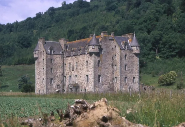
Castle Menzies Anne Burgess · CC BY-SA 2.0

Climate of Creag Moine Toll nam Broc
Best months for sightseeingBest months for sightseeing: July.
This month · November
A wet month
Day 6° · Night 0° · Rain 139 mm
- Hottest month
- July (day 16°)
- Coldest month
- February (night -3°)
- Wettest month
- January (172 mm)
- Driest month
- April (68 mm)
Bars: average monthly low and high temperature. Below: precipitation. Monthly averages for 1970–2000 at about 18 km resolution, adjusted for elevation. Highlighted months are mild and relatively dry. Source: WorldClim 2.1 (CC BY 4.0).
Show values as a table
| Month | Jan | Feb | Mar | Apr | May | Jun | Jul | Aug | Sep | Oct | Nov | Dec |
|---|---|---|---|---|---|---|---|---|---|---|---|---|
| Average high (°C) | 3° | 3° | 5° | 8° | 12° | 14° | 16° | 16° | 13° | 9° | 6° | 4° |
| Average low (°C) | -2° | -3° | -1° | 0° | 3° | 6° | 8° | 8° | 6° | 3° | 0° | -2° |
| Precipitation (mm) | 172 | 108 | 121 | 68 | 80 | 75 | 80 | 90 | 118 | 142 | 139 | 143 |
Other places to visit in this season: July
How to get to Creag Moine Toll nam Broc
The nearest airport is Dundee Airport (DND), 62 km to the southeast as the crow flies. For international flights: Edinburgh Airport (EDI) (89 km). The nearest large city is Dundee, 64 km to the east.
Airports
- Dundee Airport (DND) Dundee 62 kmsoutheast
- Edinburgh Airport (EDI) Ingliston, Edinburgh 89 kmsoutheast
- Inverness Airport (INV) Inverness, Highland 95 kmnorth
Nearby large cities
- Dundee Population: 148.2K 64 kmeast
- Edinburgh Population: 515K 94 kmsoutheast
- Glasgow Population: 626.4K 94 kmsouth
- Aberdeen Population: 198.6K 123 kmnortheast
- Newcastle upon Tyne Population: 300.1K 240 kmsoutheast
Straight-line distances; road distances are longer. Airport data: OurAirports.
Day trips from Creag Moine Toll nam Broc
Within 100 km: 163 historic and cultural sites, 4,141 natural sites, 899 lakes, rivers and coasts.
0–25 km374 places
- Isle of Spar Island 13 kmS
- Eilean nan Ubh Island 10 kmS
- Lamb Island Island 19 kmE
- Eilean Mòr Island 10 kmS
25–60 km1,773 places
- Mugdrum Island Island 57 kmSE
- Ellens Isle Island 59 kmSW
- Moncreiffe Island Island 46 kmSE
- Garbh Innis Island 60 kmSW
60–100 km3,056 places
- Burntisland Beach Beach 82 kmSE
- Cramond beach Beach 88 kmSE
- Portobello Beach Beach 96 kmSE
- Gullane Beach Beach 99 kmSE
Straight-line distances.
Nearest towns and villages
-
Foss Village, Perth and Kinross2.9 km W
-
Kirkton Village, Perth and Kinross3 km W
-
Strathtummel Village, Perth and Kinross3.2 km N
-
 Aberfeldy Village, Perth and Kinross8.6 km SE
-
Tummel Bridge Village, Perth and Kinross5.7 km W
-
 Pitlochry Village, Perth and Kinross12 km E
Nearby attractions & nature
Everything nearby-
Meall Tairbh Mountain, Perth and Kinross0.5 km NE
-
Loch Tummel Lake, Perth and Kinross1.5 km NE
-
Ciochan a' Chop Mountain, Perth and Kinross2 km SW
-
Creag an Lochain Mountain, Perth and Kinross2.3 km E
-
Creag an Loch Mountain, Perth and Kinross2.6 km S
-
Sron Mhor Mountain, Perth and Kinross2.7 km NE
-
Creag an Chanaich Mountain, Perth and Kinross2.8 km S
-
Meall Tairneachan Mountain, Perth and Kinross2.8 km S
Sources & licences
Data last updated: