- Elevation
- 459 m
- above sea level
- Local time
- UTC+00:00
- Europe/London · UTC+00:00
- Airports
- INV Inverness Airport75 km
- DND Dundee Airport81 km
About Edendon Water
Edendon Water is a river. Location: Perth and Kinross, Scotland. The best months to visit are July. The nearest airport is Inverness Airport (75 km). Nearby sights include Meall na Spianaig and Am Meadar.
Photos of Edendon Water
-
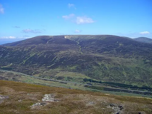
A' Bhuidheanach Bheag Mick Knapton · CC BY-SA 3.0

Climate of Edendon Water
Best months for sightseeingBest months for sightseeing: July.
This month · November
A wet month
Day 6° · Night 1° · Rain 193 mm
- Hottest month
- July (day 16°)
- Coldest month
- February (night -1°)
- Wettest month
- January (230 mm)
- Driest month
- April (95 mm)
Bars: average monthly low and high temperature. Below: precipitation. Monthly averages for 1970–2000 at about 18 km resolution, adjusted for elevation. Highlighted months are mild and relatively dry. Source: WorldClim 2.1 (CC BY 4.0).
Show values as a table
| Month | Jan | Feb | Mar | Apr | May | Jun | Jul | Aug | Sep | Oct | Nov | Dec |
|---|---|---|---|---|---|---|---|---|---|---|---|---|
| Average high (°C) | 4° | 4° | 5° | 8° | 12° | 15° | 16° | 16° | 13° | 9° | 6° | 4° |
| Average low (°C) | -1° | -1° | -1° | 1° | 4° | 7° | 9° | 9° | 7° | 4° | 1° | -1° |
| Precipitation (mm) | 230 | 148 | 170 | 95 | 101 | 95 | 100 | 118 | 161 | 193 | 193 | 198 |
Other places to visit in this season: July
How to get to Edendon Water
The nearest airport is Inverness Airport (INV), 75 km to the north as the crow flies. For international flights: Edinburgh Airport (EDI) (112 km). The nearest large city is Dundee, 82 km to the southeast.
Airports
- Inverness Airport (INV) Inverness, Highland 75 kmnorth
- Dundee Airport (DND) Dundee 81 kmsoutheast
- Edinburgh Airport (EDI) Ingliston, Edinburgh 112 kmsoutheast
Nearby large cities
- Dundee Population: 148.2K 82 kmsoutheast
- Glasgow Population: 626.4K 112 kmsouth
- Edinburgh Population: 515K 116 kmsoutheast
- Aberdeen Population: 198.6K 126 kmeast
- Newcastle upon Tyne Population: 300.1K 262 kmsoutheast
Straight-line distances; road distances are longer. Airport data: OurAirports.
Day trips from Edendon Water
Within 100 km: 81 historic and cultural sites, 4,614 natural sites, 958 lakes, rivers and coasts.
0–25 km360 places
- Eilean an Righ Island 24 kmNW
- Eilean na Cluanaich Island 22 kmN
- Eilean nan Con Island 24 kmNW
- Eilean Eas Chliabhan Island 18 kmS
25–60 km1,957 places
- Eilean na h-Ealaidh Island 46 kmNW
- Eilean Molach Island 47 kmSW
- Eilean nan Faoileag Island 59 kmN
- Bàn Eilean Island 44 kmNW
60–100 km3,336 places
- Findlays Seat Mountain 95 kmNE
- Eriska Island 88 kmSW
- Moy Island Island 81 kmN
- Shuna Island Island 84 kmW
Straight-line distances.
Nearest towns and villages
-
Gaick Lodge Village, Highland8.9 km NE
-
 Dalwhinnie Village, Highland11 km NW
-
Trinafour Village, Perth and Kinross12 km S
-
 Calvine Village, Perth and Kinross14 km SE
-
Newtonmore Village, Highland22 km N
-
Old Struan Village, Perth and Kinross15 km SE
Nearby attractions & nature
Everything nearby-
Meall na Spianaig Mountain, Perth and Kinross0.9 km NE
-
Am Meadar Mountain, Perth and Kinross2.2 km NW
-
Carn a' Mhurraich Mountain, Perth and Kinross2.3 km SE
-
Loch an Duin Lake, Perth and Kinross2.4 km N
-
Sron Odhar Mountain, Perth and Kinross3.2 km NE
-
Glas Mheall Mor Mountain, Perth and Kinross3.4 km W
-
Glas Mheall Beag Mountain, Perth and Kinross4.3 km W
-
A' Chaoirnich Mountain, Highland4.3 km NE
Sources & licences
Data last updated: