- Elevation
- 190 m
- above sea level
- Local time
- UTC+00:00
- Europe/London · UTC+00:00
- Airports
- SYY Stornoway Airport34 km
- BEB Benbecula Airport69 km
About Seaforth Island
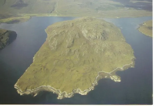
Seaforth Island is an island. Location: Western Isles, Scotland.
Seaforth Island (Scottish Gaelic: Eilean Shìphoirt/Shìophoirt or Mulag) is an uninhabited island in the Outer Hebrides of Scotland. Unlike many other islands of the Outer Hebrides which are mainly surrounded by open sea, Seaforth Island lies in a narrow fjord-like sea loch named Loch Seaforth, 8 kilometres (5.0 mi) from the open waters of The Minch. The island has poor soil which only supports rough grazing.
Source: Wikipedia · CC BY-SA 4.0
At a glance
- Topographic prominence
- 217 m
- Length
- 2.1 km
- Area
- 2.7 km²
Source: Wikidata
Photos of Seaforth Island
-

Rude Health · CC BY-SA 2.0 -

Rude Health · CC BY-SA 2.0


Climate of Seaforth Island
This month · November
A wet month
Day 8° · Night 3° · Rain 166 mm
- Hottest month
- July (day 15°)
- Coldest month
- February (night 1°)
- Wettest month
- November (166 mm)
- Driest month
- May (69 mm)
Bars: average monthly low and high temperature. Below: precipitation. Monthly averages for 1970–2000 at about 18 km resolution, adjusted for elevation. Highlighted months are mild and relatively dry. Source: WorldClim 2.1 (CC BY 4.0).
Show values as a table
| Month | Jan | Feb | Mar | Apr | May | Jun | Jul | Aug | Sep | Oct | Nov | Dec |
|---|---|---|---|---|---|---|---|---|---|---|---|---|
| Average high (°C) | 6° | 6° | 7° | 8° | 11° | 13° | 15° | 15° | 13° | 11° | 8° | 6° |
| Average low (°C) | 1° | 1° | 2° | 3° | 6° | 8° | 10° | 10° | 8° | 6° | 3° | 2° |
| Precipitation (mm) | 156 | 117 | 131 | 83 | 69 | 77 | 88 | 100 | 137 | 165 | 166 | 157 |
How to get to Seaforth Island
The nearest airport is Stornoway Airport (SYY), 34 km to the northeast as the crow flies. The nearest large city is Glasgow, 281 km to the southeast.
Airports
- Stornoway Airport (SYY) Stornoway, Western Isles 34 kmnortheast
- Benbecula Airport (BEB) Balivanich 69 kmsouthwest
- Barra Airport (BRR) Eoligarry 117 kmsouth
Nearby large cities
- Glasgow Population: 626.4K 281 kmsoutheast
- Dundee Population: 148.2K 284 kmsoutheast
- Aberdeen Population: 198.6K 293 kmeast
- Edinburgh Population: 515K 313 kmsoutheast
- Belfast Population: 348K 382 kmsouth
Straight-line distances; road distances are longer. Airport data: OurAirports.
Day trips from Seaforth Island
Within 100 km: 20 historic and cultural sites, 1,703 natural sites, 1,086 lakes, rivers and coasts.
0–25 km576 places
- Isle of Harris Natural site 12 kmS
- Scalpay Island 16 kmS
- Tannaraidh Island 23 kmNE
- Tabhaigh Mor Island 25 kmNE
25–60 km587 places
- The Coral Beaches Beach 56 kmS
- Dalmore Beach Beach 34 kmN
- Dailbeag Beach Beach 35 kmN
- Lingay Island 47 kmSW
60–100 km1,646 places
- Isle of Skye Island 83 kmS
- Island of Raasay Island 79 kmSE
- Scalpay Island 92 kmSE
- Eilean a' Char Island 76 kmE
Straight-line distances.
Nearest towns and villages
-
Ath Linne Village, Western Isles1.4 km NW
-
Aird a Mhulaidh Village, Western Isles2.1 km W
-
Maraig Village, Western Isles5.1 km S
-
Eilean Anabuich Village, Western Isles5.4 km S
-
Bunavoneader Village, Western Isles8.2 km SW
-
Rhenigidale Village, Western Isles9.5 km S
Nearby attractions & nature
Everything nearby-
Eilean Shìophoirt Island, Western Isles0.5 km SE
-
Creagan Ghlasa Mountain, Western Isles2.7 km S
-
Beinn a' Mhuil Mountain, Western Isles2.8 km NW
-
Cithis Mhor Mountain, Western Isles3 km NE
-
Cleit Ard Mountain, Western Isles3 km SW
-
Liuthaid Mountain, Western Isles4 km NW
-
Mullach a' Ruisg Mountain, Western Isles4.1 km W
-
Cithis Bheag Mountain, Western Isles4.6 km NE
Sources & licences
Data last updated: · 2 independent sources