Bruderndorf
Located in Langschlag, Politischer Bezirk Zwettl Coordinates: 48°35′38″ N 14°51′32″ E
- Population
- 120
- 120
- Elevation
- 778 m
- above sea level
- Local time
- UTC+01:00
- Europe/Vienna · UTC+01:00
- Airports
- JCL České Budějovice South Bohemian Airport51 km
- LNZ Linz-Hörsching Airport64 km
About Bruderndorf
Bruderndorf is a village. Location: Langschlag, Politischer Bezirk Zwettl. Population: 120. Elevation: 778 m. The best months to visit are June–August. The nearest airport is České Budějovice South Bohemian Airport (51 km). Nearby sights include Waldliess and Schroffen Berg.
Climate of Bruderndorf
Best months for sightseeingBest months for sightseeing: June–August.
This month · November
A cold month
Day 4° · Night -2° · Rain 58 mm
- Hottest month
- July (day 21°)
- Coldest month
- January (night -7°)
- Wettest month
- July (115 mm)
- Driest month
- February (46 mm)
Bars: average monthly low and high temperature. Below: precipitation. Monthly averages for 1970–2000 at about 18 km resolution, adjusted for elevation. Highlighted months are mild and relatively dry. Source: WorldClim 2.1 (CC BY 4.0).
Show values as a table
| Month | Jan | Feb | Mar | Apr | May | Jun | Jul | Aug | Sep | Oct | Nov | Dec |
|---|---|---|---|---|---|---|---|---|---|---|---|---|
| Average high (°C) | 0° | 2° | 6° | 10° | 16° | 19° | 21° | 21° | 16° | 11° | 4° | 1° |
| Average low (°C) | -7° | -6° | -3° | 0° | 5° | 8° | 10° | 9° | 6° | 2° | -2° | -5° |
| Precipitation (mm) | 49 | 46 | 60 | 65 | 82 | 103 | 115 | 94 | 68 | 51 | 58 | 58 |
How to get to Bruderndorf
The nearest airport is České Budějovice South Bohemian Airport (JCL), 51 km to the northwest as the crow flies. The nearest large city is Linz, 53 km to the southwest.
Airports
- České Budějovice South Bohemian Airport (JCL) České Budějovice 51 kmnorthwest
- Linz-Hörsching Airport (LNZ) Linz 64 kmsouthwest
- Vienna International Airport (VIE) Vienna 138 kmeast
Nearby large cities
- Linz Population: 204.8K 53 kmsouthwest
- Brno Population: 404.3K 145 kmnortheast
- Salzburg Population: 157.2K 161 kmsouthwest
- Prague Population: 1.2M 169 kmnorth
- Bratislava Population: 423.7K 174 kmeast
Straight-line distances; road distances are longer. Airport data: OurAirports.
Day trips from Bruderndorf
Within 100 km: 173 historic and cultural sites, 1,332 natural sites, 380 lakes, rivers and coasts.
0–25 km71 places
- Unter-Rosenhofer Teich Lake 14 kmW
- Ober-Rosenhofer Teich Lake 14 kmW
- Steinberg Mountain 25 kmN
- Wackelstein Mountain 23 kmNE
25–60 km561 places
- Gassner Camel Riding School Natural site 48 kmSE
- Gusen I Concentration Camp Historic site 47 kmSW
- Kranbühel Mountain 46 kmNE
- Hutbühel Mountain 39 kmNE
60–100 km1,253 places
- Waldsee Lake 90 kmE
- Obersee Lake 90 kmS
- Mittersee Lake 86 kmS
- Lunzer See Lake 82 kmS
Straight-line distances.
Nearby attractions & nature
Everything nearby-
Waldliess Mountain, Groß Gerungs5.6 km E
-
Schroffen Berg Mountain, Großschönau6 km NE
-
Teicher Forst Natural site, Austria6.4 km SW
-
Johannes Berg Mountain, Weitra6.9 km NE
-
Wach Berg Mountain, St. Martin7 km NW
-
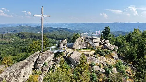 Nebelstein Mountain, Moorbad Harbach11 km NW
Sources & licences
Data last updated: