Eggerbügl
Located in Sankt Lambrecht, Politischer Bezirk Murau Coordinates: 47°07′00″ N 14°16′00″ E
- Elevation
- 1,322 m
- above sea level
- Local time
- UTC+01:00
- Europe/Vienna · UTC+01:00
- Airports
- KLU Klagenfurt Airport53 km
- GRZ Graz Airport90 km
About Eggerbügl
Eggerbügl is a mountain. Location: Sankt Lambrecht, Politischer Bezirk Murau. Elevation: 1,322 m. The best months to visit are July–August. The nearest airport is Klagenfurt Airport (53 km). Nearby sights include Reuterkogel and Mühlsteinboden.
Photos of Eggerbügl
-
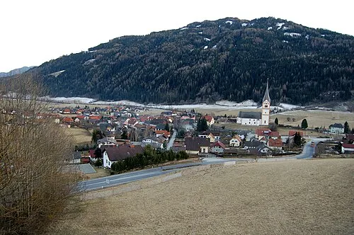
Stolzalpe Herzi Pinki · CC BY-SA 4.0

Climate of Eggerbügl
Best months for sightseeingBest months for sightseeing: July–August.
This month · November
A wet month
Day 3° · Night -5° · Rain 102 mm
- Hottest month
- July (day 18°)
- Coldest month
- January (night -9°)
- Wettest month
- July (166 mm)
- Driest month
- February (60 mm)
Bars: average monthly low and high temperature. Below: precipitation. Monthly averages for 1970–2000 at about 18 km resolution, adjusted for elevation. Highlighted months are mild and relatively dry. Source: WorldClim 2.1 (CC BY 4.0).
Show values as a table
| Month | Jan | Feb | Mar | Apr | May | Jun | Jul | Aug | Sep | Oct | Nov | Dec |
|---|---|---|---|---|---|---|---|---|---|---|---|---|
| Average high (°C) | -1° | 1° | 4° | 8° | 13° | 16° | 18° | 18° | 15° | 10° | 3° | 0° |
| Average low (°C) | -9° | -9° | -6° | -2° | 2° | 6° | 8° | 8° | 4° | 0° | -5° | -8° |
| Precipitation (mm) | 61 | 60 | 87 | 100 | 116 | 160 | 166 | 144 | 127 | 106 | 102 | 84 |
How to get to Eggerbügl
The nearest airport is Klagenfurt Airport (KLU), 53 km to the south as the crow flies. The nearest large city is Klagenfurt, 55 km to the south.
Airports
- Klagenfurt Airport (KLU) Klagenfurt am Wörthersee 53 kmsouth
- Graz Airport (GRZ) Feldkirchen bei Graz 90 kmeast
- Ljubljana Jože Pučnik Airport (LJU) Zgornji Brnik 100 kmsouth
Nearby large cities
- Klagenfurt Population: 100.3K 55 kmsouth
- Graz Population: 303.3K 89 kmeast
- Salzburg Population: 157.2K 119 kmnorthwest
- Ljubljana Population: 272.2K 120 kmsouth
- Linz Population: 204.8K 132 kmnorth
Straight-line distances; road distances are longer. Airport data: OurAirports.
Day trips from Eggerbügl
Within 100 km: 297 historic and cultural sites, 3,149 natural sites, 926 lakes, rivers and coasts.
0–25 km228 places
- Großer Winterleitensee Lake 22 kmE
- Wildsee Lake 23 kmN
- Mirtzlsee Lake 23 kmNW
- Lindersee Lake 24 kmE
25–60 km1,481 places
- Klamm Natural site 45 kmN
- Seeriessee Lake 47 kmNW
- Untersee Lake 57 kmNW
- Wildsee Lake 48 kmW
60–100 km2,663 places
- Hoher Dachstein Mountain 64 kmNW
- Lake Bohinj Lake 97 kmS
- Lake Bled Lake 85 kmS
- Triglav Mountain 88 kmS
Straight-line distances.
Nearest towns and villages
-
Teufenbach-Katsch Municipality, Politischer Bezirk Murau3.8 km NE
-
Katsch an der Mur Village, Teufenbach-Katsch3.5 km N
-
Frojach Village, Teufenbach-Katsch3.6 km NE
-
Sankt Blasen Village, Sankt Lambrecht4.5 km SE
-
Karchau Village, Sankt Lambrecht2.2 km SW
-
Triebendorf Village, Murau2.5 km W
Nearby attractions & nature
Everything nearby-
Reuterkogel Mountain, Sankt Lambrecht0.2 km E
-
Mühlsteinboden Mountain, Sankt Lambrecht2.4 km SE
-
Blasenkogl Mountain, Teufenbach-Katsch2.5 km E
-
Katschbach River, Styria2.2 km NE
-
Karchauer Eck Mountain, Sankt Lambrecht3.9 km S
-
Stolzalpe Mountain, Ranten7.3 km NW
-
Pleschaitz Mountain, Oberwölz6.1 km NE
-
Ofneralpe Mountain, Murau6.1 km SW
Sources & licences
Data last updated: