Oberellbögen
Located in Ellbögen, Politischer Bezirk Innsbruck Land Coordinates: 47°11′00″ N 11°27′00″ E
- Elevation
- 1,433 m
- above sea level
- Local time
- UTC+01:00
- Europe/Vienna · UTC+01:00
- Airports
- INN Innsbruck Airport12 km
- BZO Bolzano Airport81 km
About Oberellbögen
Oberellbögen is a village. Location: Ellbögen, Politischer Bezirk Innsbruck Land. Elevation: 1,433 m. The best months to visit are July–August. The nearest airport is Innsbruck Airport (12 km). Nearby sights include Viggartal and Europabrücke.
Photos of Oberellbögen
-
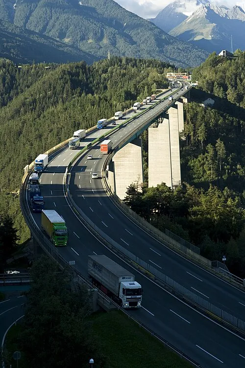
Europabrücke The original uploader was Rhilber at German Wikipedia · CC BY-SA 2.0 de

Climate of Oberellbögen
Best months for sightseeingBest months for sightseeing: July–August.
This month · November
A cold month
Day 4° · Night -3° · Rain 76 mm
- Hottest month
- July (day 19°)
- Coldest month
- January (night -7°)
- Wettest month
- July (151 mm)
- Driest month
- February (50 mm)
Bars: average monthly low and high temperature. Below: precipitation. Monthly averages for 1970–2000 at about 18 km resolution, adjusted for elevation. Highlighted months are mild and relatively dry. Source: WorldClim 2.1 (CC BY 4.0).
Show values as a table
| Month | Jan | Feb | Mar | Apr | May | Jun | Jul | Aug | Sep | Oct | Nov | Dec |
|---|---|---|---|---|---|---|---|---|---|---|---|---|
| Average high (°C) | 0° | 2° | 5° | 8° | 14° | 17° | 19° | 19° | 15° | 10° | 4° | 0° |
| Average low (°C) | -7° | -7° | -4° | -1° | 4° | 7° | 9° | 9° | 6° | 2° | -3° | -6° |
| Precipitation (mm) | 53 | 50 | 67 | 77 | 102 | 138 | 151 | 137 | 95 | 74 | 76 | 63 |
How to get to Oberellbögen
The nearest airport is Innsbruck Airport (INN), 12 km to the northwest as the crow flies. The nearest large city is Innsbruck, 10 km to the northwest.
Airports
- Innsbruck Airport (INN) Innsbruck 12 kmnorthwest
- Bolzano Airport (BZO) Bolzano (BZ) 81 kmsouth
- Memmingen Allgau Airport (FMM) Memmingen 128 kmnorthwest
Nearby large cities
- Innsbruck Population: 132.5K 10 kmnorthwest
- Munich Population: 1.5M 106 kmnorth
- Salzburg Population: 157.2K 138 kmnortheast
- Augsburg Population: 301.1K 138 kmnorth
- Ulm Population: 120.5K 174 kmnorthwest
Straight-line distances; road distances are longer. Airport data: OurAirports.
Day trips from Oberellbögen
Within 100 km: 184 historic and cultural sites, 4,878 natural sites, 1,089 lakes, rivers and coasts.
0–25 km264 places
- Wild See Lake 23 kmS
- Torseen Lake 18 kmE
- Obernberger See Lake 23 kmS
- Juns See Lake 15 kmE
25–60 km1,951 places
- Bayerisches Oberland Mountain 53 kmN
- Wildsee Lake 25 kmNW
- Zireiner See Lake 42 kmNE
- Wilder See Lake 44 kmW
60–100 km3,936 places
- Schloss Hirschberg am Haarsee Historic site 72 kmN
- Lai da Sesvenna Lake 95 kmSW
- Lajet da Lischana Lake 96 kmSW
- Ils Lajets Lake 96 kmSW
Straight-line distances.
Nearby attractions & nature
Everything nearby-
Viggartal Natural site, Tyrol1.9 km N
-
Europabrücke Landmark, Schönberg im Stubaital4.2 km NW
-
Arztal Natural site, Tyrol2.5 km E
-
Falkansaner Bach River, Tyrol1.9 km S
-
Morgenkogel Mountain, Ellbögen3.8 km E
-
Patscherkofel Mountain, Patsch2.9 km N
Sources & licences
Data last updated: