Oberperfuss
Located in Politischer Bezirk Innsbruck Land, Tyrol Coordinates: 47°14′14″ N 11°12′37″ E
- Population
- 3,043
- 3K
- Elevation
- 1,470 m
- above sea level
- Local time
- UTC+01:00
- Europe/Vienna · UTC+01:00
- Places inside
- 4
- listed under Oberperfuss
- Airports
- INN Innsbruck Airport10 km
- BZO Bolzano Airport87 km
About Oberperfuss
Oberperfuss is a municipality. Location: Politischer Bezirk Innsbruck Land, Tyrol. Population: 3,043. Elevation: 1,470 m. The best months to visit are July–August. The nearest airport is Innsbruck Airport (10 km). Nearby sights include Fotscherbach and Salfains.
Photos of Oberperfuss
-
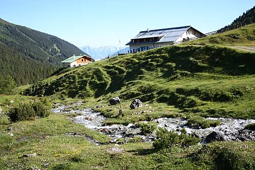
Senderstal Simon Legner · CC BY-SA 4.0

Climate of Oberperfuss
Best months for sightseeingBest months for sightseeing: July–August.
This month · November
A cold month
Day 4° · Night -3° · Rain 77 mm
- Hottest month
- July (day 18°)
- Coldest month
- January (night -7°)
- Wettest month
- July (150 mm)
- Driest month
- February (52 mm)
Bars: average monthly low and high temperature. Below: precipitation. Monthly averages for 1970–2000 at about 18 km resolution, adjusted for elevation. Highlighted months are mild and relatively dry. Source: WorldClim 2.1 (CC BY 4.0).
Show values as a table
| Month | Jan | Feb | Mar | Apr | May | Jun | Jul | Aug | Sep | Oct | Nov | Dec |
|---|---|---|---|---|---|---|---|---|---|---|---|---|
| Average high (°C) | 0° | 1° | 5° | 7° | 13° | 16° | 18° | 18° | 15° | 10° | 4° | 1° |
| Average low (°C) | -7° | -7° | -4° | -1° | 4° | 6° | 9° | 9° | 6° | 2° | -3° | -6° |
| Precipitation (mm) | 56 | 52 | 68 | 79 | 103 | 140 | 150 | 137 | 95 | 75 | 77 | 66 |
How to get to Oberperfuss
The nearest airport is Innsbruck Airport (INN), 10 km to the east as the crow flies. The nearest large city is Innsbruck, 14 km to the east.
Airports
- Innsbruck Airport (INN) Innsbruck 10 kmeast
- Bolzano Airport (BZO) Bolzano (BZ) 87 kmsouth
- Memmingen Allgau Airport (FMM) Memmingen 111 kmnorthwest
Nearby large cities
- Innsbruck Population: 132.5K 14 kmeast
- Munich Population: 1.5M 104 kmnorth
- Augsburg Population: 301.1K 128 kmnorth
- Salzburg Population: 157.2K 152 kmnortheast
- Ulm Population: 120.5K 158 kmnorthwest
Straight-line distances; road distances are longer. Airport data: OurAirports.
Day trips from Oberperfuss
Within 100 km: 228 historic and cultural sites, 5,048 natural sites, 1,088 lakes, rivers and coasts.
0–25 km383 places
- Wildsee Lake 9 kmN
- Taxersee Lake 7 kmW
- Igel See Lake 25 kmNW
- Grastalsee Lake 22 kmSW
25–60 km2,022 places
- Bayerisches Oberland Mountain 48 kmN
- Zireiner See Lake 52 kmNE
- Wild See Lake 38 kmSE
- Wilder See Lake 30 kmSW
60–100 km3,959 places
- Schloss Hirschberg am Haarsee Historic site 64 kmN
- Lai da Juata Lake 94 kmSW
- Lai Sura Lake 100 kmSW
- Lai Verd Lake 92 kmSW
Straight-line distances.
Places in Oberperfuss
4 placesBar: population relative to the most populous place in this list.
Cities & villages2
- Mairhof · Village
- Völsergasse · Village
Mountains & nature1
- Rangger Köpfl · Mountain
Nearby attractions & nature
Everything nearby-
Fotscherbach River, Tyrol2.3 km S
-
Salfains Mountain, Sellrain4.5 km SE
-
Melach River, Tyrol4.5 km NE
-
Roßkogel Mountain, Gries im Sellrain5.1 km SW
-
Kalvarienberg Mountain, Zirl5.1 km NE
-
Senderstal Natural site, Tyrol7.4 km SE
-
Rauher Kopf = Flaurling Mountain, Flaurling5.9 km W
-
Grieskogel Mountain, Sellrain6.1 km SE
Sources & licences
Data last updated: