Arrondissement of Neufchâteau
Located in Luxembourg Province, Wallonia Coordinates: 49°55′00″ N 5°20′01″ E
- Population
- 62,777
- 62.8K
- Elevation
- 488 m
- above sea level
- Local time
- UTC+01:00
- Europe/Brussels · UTC+01:00
- Places inside
- 12
- listed under Arrondissement of Neufchâteau
- Airports
- LUX Luxembourg-Findel International Airport71 km
- LGG Liège Airport81 km
About Arrondissement of Neufchâteau
Arrondissement of Neufchâteau is a municipality. Location: Luxembourg Province, Wallonia. Population: 62,777. Elevation: 488 m. The best months to visit are June–August. The nearest airport is Luxembourg-Findel International Airport (71 km). Nearby sights include Bois de Bannet and Bois de Behègne.
Climate of Arrondissement of Neufchâteau
Best months for sightseeingBest months for sightseeing: June–August.
This month · November
A wet month
Day 6° · Night 1° · Rain 102 mm
- Hottest month
- August (day 21°)
- Coldest month
- February (night -2°)
- Wettest month
- December (106 mm)
- Driest month
- April (72 mm)
Bars: average monthly low and high temperature. Below: precipitation. Monthly averages for 1970–2000 at about 18 km resolution, adjusted for elevation. Highlighted months are mild and relatively dry. Source: WorldClim 2.1 (CC BY 4.0).
Show values as a table
| Month | Jan | Feb | Mar | Apr | May | Jun | Jul | Aug | Sep | Oct | Nov | Dec |
|---|---|---|---|---|---|---|---|---|---|---|---|---|
| Average high (°C) | 3° | 4° | 7° | 11° | 16° | 18° | 20° | 21° | 17° | 12° | 6° | 4° |
| Average low (°C) | -2° | -2° | 1° | 2° | 7° | 9° | 11° | 11° | 9° | 5° | 1° | -1° |
| Precipitation (mm) | 97 | 81 | 87 | 72 | 84 | 88 | 87 | 84 | 79 | 90 | 102 | 106 |
How to get to Arrondissement of Neufchâteau
The nearest airport is Luxembourg-Findel International Airport (LUX), 71 km to the southeast as the crow flies. The nearest large city is Namur, 70 km to the northwest.
Airports
- Luxembourg-Findel International Airport (LUX) Luxembourg 71 kmsoutheast
- Liège Airport (LGG) Grâce-Hollogne 81 kmnorth
- Brussels South Charleroi Airport (CRL) Charleroi 87 kmnorthwest
Nearby large cities
- Namur Population: 110.9K 70 kmnorthwest
- Liège Population: 195.3K 81 kmnorth
- Charleroi Population: 200.1K 84 kmnorthwest
- Trier Population: 100.1K 96 kmeast
- Maastricht Population: 122.4K 107 kmnorth
Straight-line distances; road distances are longer. Airport data: OurAirports.
Day trips from Arrondissement of Neufchâteau
Within 100 km: 184 historic and cultural sites, 1,608 natural sites, 589 lakes, rivers and coasts.
0–25 km241 places
- Étang des Épioux Lake 18 kmS
- Haie de Wez Natural site 9 kmW
- Bois de Wève Natural site 22 kmN
- Bois de Wavre Natural site 16 kmE
25–60 km681 places
- Château de Berg Historic site 55 kmE
- Île d'Androssart Island 47 kmNW
- Étang de Boiron Lake 32 kmW
- Lac de Nisramont Lake 35 kmNE
60–100 km1,459 places
- Île du Moulin Island 75 kmN
- Île Monsin Island 85 kmN
- Île de Franche Garenne Island 91 kmN
- Étang de Virelles Lake 73 kmW
Straight-line distances.
Arrondissement of Neufchâteau and similar cities
Side by side with cities of similar size in the same country: population, elevation and climate.
| Measure | Arrondissement of Neufchâteau | Leuven | Namur | Bruges |
|---|---|---|---|---|
| Population | 62.8K | 101K | 110.9K | 118.5K |
| Elevation | 488 m | 28 m | 88 m | 13 m |
| Summer day (hottest month) | 21° | 23° | 23° | 22° |
| Winter night (coldest month) | -2° | 1° | 0° | 1° |
| Annual rainfall | 1,057 mm | 765 mm | 813 mm | 783 mm |
| Best months | Jun–Aug | Jun–Aug | Jun–Aug | Jun–Sep |
| Distance | — | 116 km | 70 km | 207 km |
Climate values are 1970–2000 monthly averages; straight-line distance.
Places in Arrondissement of Neufchâteau
12 places- 1 Libramont-Chevigny 11.3K
- 2 Bertrix 8.8K
- 3 Neufchâteau 7.7K
- 4 Saint-Hubert 5.6K
- 5 Léglise 5.5K
- 6 Bouillon 5.4K
- 7 Paliseul 5.4K
- 8 Libin 5.2K
- 9 Wellin 3.1K
- 10 Tellin 2.4K
- 11 Herbeumont 1.6K
- 12 Daverdisse 1.4K
Bar: population relative to the most populous place in this list.
Nearby attractions & nature
Everything nearby-
Bois de Bannet Natural site, Luxembourg Province1.5 km NW
-
Bois de Behègne Natural site, Luxembourg Province2.4 km N
-
Aux Vieilles Huttes Natural site, Luxembourg Province3.3 km N
-
Bois de Bernihet Natural site, Luxembourg Province3.3 km NE
-
Bois de Mochamps Natural site, Luxembourg Province3.6 km NE
-
Grande Huqueny Natural site, Luxembourg Province3.7 km S
-
Bois de la Haie Natural site, Luxembourg Province3.8 km NW
-
Forêt de Luchy Natural site, Luxembourg Province3.8 km SW
Other cities and towns in Luxembourg Province
-
Neufchâteau Town, Neufchâteau11 km SE
-
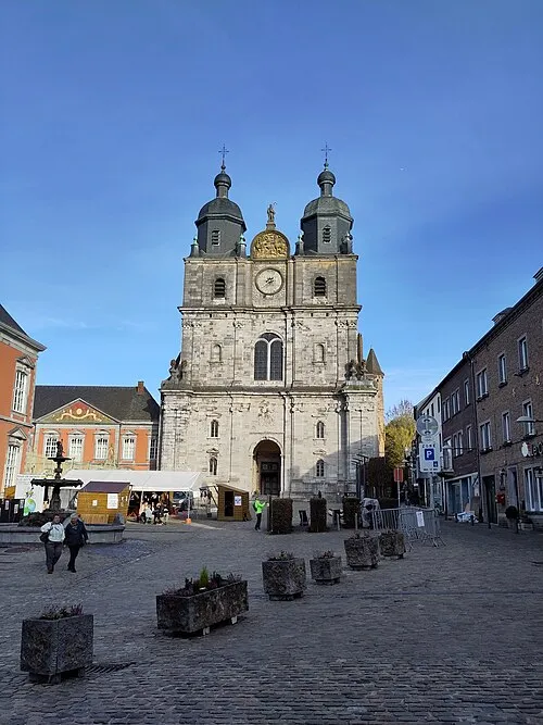 Saint-Hubert Town, Saint-Hubert13 km N
-
Bertrix Town, Bertrix8.8 km SW
-
Arrondissement of Bastogne Municipality, Luxembourg Province34 km NE
-
Arrondissement de Marche-en-Famenne Municipality, Luxembourg Province36 km N
-
Paliseul Town, Paliseul14 km W
Sources & licences
Data last updated: