Fontaine Debucq
Located in Namur Province, Wallonia Coordinates: 50°27′00″ N 4°58′00″ E
- Elevation
- 185 m
- above sea level
- Local time
- UTC+01:00
- Europe/Brussels · UTC+01:00
- Airports
- CRL Brussels South Charleroi Airport36 km
- LGG Liège Airport40 km
About Fontaine Debucq
Fontaine Debucq is a natural site. Location: Namur Province, Wallonia. The best months to visit are June–August. The nearest airport is Brussels South Charleroi Airport (36 km). Nearby sights include Fontaine Fosette and Bois de Jeumont.
Photos of Fontaine Debucq
-
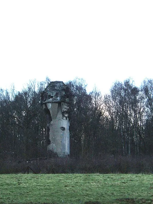
Fort de Marchovelette LHOON · CC BY 2.0

Climate of Fontaine Debucq
Best months for sightseeingBest months for sightseeing: June–August.
This month · November
A cold month
Day 8° · Night 3° · Rain 74 mm
- Hottest month
- August (day 22°)
- Coldest month
- February (night 0°)
- Wettest month
- June (77 mm)
- Driest month
- February (55 mm)
Bars: average monthly low and high temperature. Below: precipitation. Monthly averages for 1970–2000 at about 18 km resolution, adjusted for elevation. Highlighted months are mild and relatively dry. Source: WorldClim 2.1 (CC BY 4.0).
Show values as a table
| Month | Jan | Feb | Mar | Apr | May | Jun | Jul | Aug | Sep | Oct | Nov | Dec |
|---|---|---|---|---|---|---|---|---|---|---|---|---|
| Average high (°C) | 5° | 6° | 9° | 13° | 17° | 20° | 22° | 22° | 18° | 14° | 8° | 6° |
| Average low (°C) | 0° | 0° | 2° | 4° | 8° | 11° | 13° | 13° | 10° | 7° | 3° | 1° |
| Precipitation (mm) | 64 | 55 | 65 | 59 | 70 | 77 | 74 | 72 | 62 | 68 | 74 | 73 |
How to get to Fontaine Debucq
The nearest airport is Brussels South Charleroi Airport (CRL), 36 km to the west as the crow flies. The nearest large city is Namur, 7 km to the west.
Airports
- Brussels South Charleroi Airport (CRL) Charleroi 36 kmwest
- Liège Airport (LGG) Grâce-Hollogne 40 kmnortheast
- Brussels Airport (BRU) Zaventem 61 kmnorthwest
Nearby large cities
- Namur Population: 110.9K 7 kmwest
- Charleroi Population: 200.1K 37 kmwest
- Liège Population: 195.3K 47 kmnortheast
- Leuven Population: 101K 51 kmnorth
- Brussels Population: 1M 62 kmnorthwest
Straight-line distances; road distances are longer. Airport data: OurAirports.
Day trips from Fontaine Debucq
Within 100 km: 261 historic and cultural sites, 1,531 natural sites, 1,126 lakes, rivers and coasts.
0–25 km194 places
- Grand Étang de Fosse Lake 22 kmSW
- Nameche terril Mountain 3 kmNE
- Bois de Weillen Natural site 24 kmSW
- Bois Wanchalle Natural site 4 kmW
25–60 km1,098 places
- Île du Moulin Island 47 kmE
- Île Monsin Island 53 kmNE
- Île de Franche Garenne Island 58 kmNE
- Île d'Androssart Island 31 kmS
60–100 km1,626 places
- Étang de Virelles Lake 61 kmSW
- Étang de Séloignes Lake 69 kmSW
- Étang d'Oise Lake 72 kmSW
- Étang du Moulin Lake 61 kmSW
Straight-line distances.
Nearest towns and villages
Nearby attractions & nature
Everything nearby-
Fontaine Fosette Natural site, Namur Province<0.1 km N
-
Bois de Jeumont Natural site, Namur Province2 km SW
-
Bois de Fessenne Natural site, Namur Province2.3 km NW
-
Nameche terril Mountain, Andenne3.2 km NE
-
Ruisseau du Tronquois River, Namur Province1.8 km SE
-
Bois de l'Évèque Natural site, Namur Province3.5 km W
-
Bois Wanchalle Natural site, Namur Province3.7 km W
-
Bois de Floreffe Natural site, Namur Province4.4 km NW
Sources & licences
Data last updated: