
- Elevation
- 1,872 m
- above sea level
- Local time
- UTC+01:00
- Europe/Sarajevo · UTC+01:00
- Airports
- SPU Split Saint Jerome Airport74 km
- BWK Brač Airport99 km
About Šator Planina
Šator Planina is a mountain. Location: Bosnia and Herzegovina. Elevation: 1,872 m.
Šator (Serbian Cyrillic: Шатор) is a mountain in the Dinaric Alps, in the western regions of Bosnia and Herzegovina. The name šator means "tent". The highest peak Veliki Šator is 1,872 m (6,142 ft) above sea level. Dimensions of the mountain are some 15 km (9 miles) in the west–east and 10 km (6 miles) in the north–south direction. The mountain area includes a lake, rich flora and fauna, numerous geomorphological and hydrological phenomena, as well as the aesthetic appearance in general.
Source: Wikipedia · CC BY-SA 4.0
At a glance
- Length
- 15 km
Source: Wikidata
Photos of Šator Planina
-

Julian Nyča · CC BY-SA 4.0 -

Julian Nyča · CC BY-SA 4.0 -

Unknown author Unknown author · CC0 -

Šatorsko Jezero Martin Brož · CC BY 3.0


Climate of Šator Planina
Best months for sightseeingBest months for sightseeing: July–August.
This month · November
A wet month
Day 2° · Night -6° · Rain 138 mm
- Hottest month
- August (day 17°)
- Coldest month
- January (night -11°)
- Wettest month
- November (138 mm)
- Driest month
- July (74 mm)
Bars: average monthly low and high temperature. Below: precipitation. Monthly averages for 1970–2000 at about 18 km resolution, adjusted for elevation. Highlighted months are mild and relatively dry. Source: WorldClim 2.1 (CC BY 4.0).
Show values as a table
| Month | Jan | Feb | Mar | Apr | May | Jun | Jul | Aug | Sep | Oct | Nov | Dec |
|---|---|---|---|---|---|---|---|---|---|---|---|---|
| Average high (°C) | -4° | -3° | 1° | 6° | 11° | 14° | 17° | 17° | 13° | 8° | 2° | -3° |
| Average low (°C) | -11° | -10° | -8° | -4° | 0° | 3° | 5° | 4° | 2° | -2° | -6° | -9° |
| Precipitation (mm) | 80 | 80 | 85 | 100 | 92 | 97 | 74 | 81 | 104 | 118 | 138 | 113 |
How to get to Šator Planina
The nearest airport is Split Saint Jerome Airport (SPU), 74 km to the south as the crow flies. The nearest large city is Split, 75 km to the south.
Airports
- Split Saint Jerome Airport (SPU) Split 74 kmsouth
- Brač Airport (BWK) Gornji Humac 99 kmsouth
- Zadar Airport (ZAD) Zadar 100 kmwest
Nearby large cities
- Split Population: 149.8K 75 kmsouth
- Banja Luka Population: 221.1K 83 kmnortheast
- Zenica Population: 164.4K 104 kmeast
- Mostar Population: 104.5K 134 kmsoutheast
- Sarajevo Population: 696.7K 145 kmeast
Straight-line distances; road distances are longer. Airport data: OurAirports.
Day trips from Šator Planina
Within 100 km: 9 historic and cultural sites, 101 natural sites, 95 lakes, rivers and coasts.
0–25 km8 places
- Dinara Mountain 21 kmSW
- Staretina Mountain 11 kmSE
- Šator Mountain 2 kmE
- Šatorsko Jezero Lake 1 kmS
25–60 km54 places
- Omsica Mountain 58 kmW
- Burnum Historic site 53 kmW
- Oštrelj Mountain 58 kmN
- Rudo Brdo Mountain 58 kmN
60–100 km143 places
- Brač Island 94 kmS
- Šolta Island 91 kmS
- Otok Prvić Island 81 kmSW
- Otok Zlarin Island 81 kmSW
Straight-line distances.
Nearest towns and villages
-
Preodac Village, Federation of Bosnia and Herzegovina4.9 km N
-
Crnac Village, Federation of Bosnia and Herzegovina5.1 km W
-
Nuglašica Village, Federation of Bosnia and Herzegovina7.1 km S
-
Rore Village, Federation of Bosnia and Herzegovina7.7 km NE
-
Veliko Tičevo Village, Federation of Bosnia and Herzegovina7.7 km NW
-
Popovići Village, Federation of Bosnia and Herzegovina7.8 km E
Nearby attractions & nature
Everything nearby-
Šatorsko Jezero Lake, Federation of Bosnia and Herzegovina0.5 km S
-
Šator Mountain, Federation of Bosnia and Herzegovina2 km E
-
Drage Natural site, Federation of Bosnia and Herzegovina7.7 km N
-
Staretina Mountain, Federation of Bosnia and Herzegovina11 km SE
-
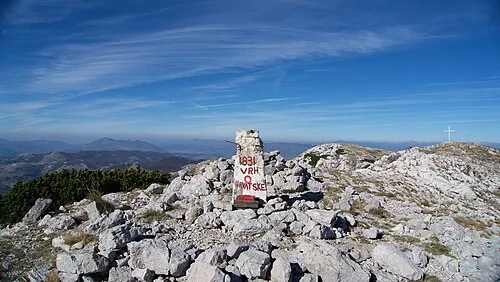 Dinara Mountain, Šibenik-Knin County21 km SW
-
 Veliki Troglav Mountain, Federation of Bosnia and Herzegovina25 km S
-
Jezero Župica Lake, Federation of Bosnia and Herzegovina16 km NW
-
Ribnik River, Federation of Bosnia and Herzegovina22 km E
More nature in Bosnia and Herzegovina
-
Vrba Natural site, Federation of Bosnia and Herzegovina30 km SE
-
 Velika Golija Mountain, Federation of Bosnia and Herzegovina33 km SE
-
 Dinaric Alps Mountain, Bosnia and Herzegovina37 km S
-
Ploče Mountain, Bosnia and Herzegovina33 km E
-
Ujilica Mountain, Federation of Bosnia and Herzegovina31 km NW
-
 Vitorog Mountain, Bosnia and Herzegovina36 km E
Sources & licences
Data last updated: · 2 independent sources