Kato Akourdhalia
Local name: Κάτω Ακουρδάλια
Located in Káto Akourdáleia, Pafos Coordinates: 34°57′10″ N 32°27′04″ E

- Population
- 65
- 65
- Elevation
- 312 m
- above sea level
- Local time
- UTC+02:00
- Asia/Nicosia · UTC+02:00
- Airports
- PFO Paphos International Airport26 km
- ECN Ercan International Airport99 km
About Kato Akourdhalia
Kato Akourdhalia is a village. Location: Káto Akourdáleia, Pafos. Population: 65. Elevation: 312 m.
Kato Akourdhalia (Greek: Κάτω Ακουρδάλια) (alternative spellings are Kato Akourdalia or Kato Akourdaleia) is a village in the Paphos District of Cyprus, located 2 km northwest of Miliou. The name 'Akourdhalia' has several purported roots.
Source: Wikipedia · CC BY-SA 4.0
At a glance
- Area
- 3 km²
Source: Wikidata
Photos of Kato Akourdhalia
-
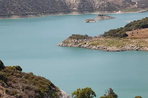
Evretou Reservoir Dm Bsg · CC BY 3.0

Places bordering Kato Akourdhalia
- Skoulli
- Evretou
- Loukrounou
- Miliou
- Pano Akourdaleia
- Kritou Terra
Population of Kato Akourdhalia over time
| 1901 | 103 | |
|---|---|---|
| 1911 | 115 | |
| 1921 | 117 | |
| 1931 | 110 | |
| 1946 | 121 | |
| 1960 | 98 | |
| 1973 | 81 | |
| 1976 | 88 | |
| 1982 | 64 | |
| 1992 | 42 | |
| 2001 | 32 | |
| 2011 | 65 |
Censuses and official estimates; source: Wikidata.
Climate of Kato Akourdhalia
Best months for sightseeingBest months for sightseeing: April–May, October–November.
This month · November
A good month to visit
Day 20° · Night 10° · Rain 58 mm
- Hottest month
- August (day 32°)
- Coldest month
- January (night 5°)
- Wettest month
- December (107 mm)
- Driest month
- July (2 mm)
Bars: average monthly low and high temperature. Below: precipitation. Monthly averages for 1970–2000 at about 18 km resolution, adjusted for elevation. Highlighted months are mild and relatively dry. Source: WorldClim 2.1 (CC BY 4.0).
Show values as a table
| Month | Jan | Feb | Mar | Apr | May | Jun | Jul | Aug | Sep | Oct | Nov | Dec |
|---|---|---|---|---|---|---|---|---|---|---|---|---|
| Average high (°C) | 14° | 15° | 17° | 21° | 25° | 29° | 31° | 32° | 29° | 25° | 20° | 16° |
| Average low (°C) | 5° | 5° | 7° | 10° | 13° | 17° | 19° | 20° | 17° | 14° | 10° | 7° |
| Precipitation (mm) | 104 | 76 | 61 | 29 | 17 | 6 | 2 | 2 | 5 | 35 | 58 | 107 |
Other places to visit in this season: April May October November
How to get to Kato Akourdhalia
The nearest airport is Paphos International Airport (PFO), 26 km to the south as the crow flies. The nearest large city is Limassol, 61 km to the southeast.
Airports
- Paphos International Airport (PFO) Paphos 26 kmsouth
- Ercan International Airport (ECN) Tymbou (Kirklar) 99 kmeast
- Larnaca International Airport (LCA) Larnaca 108 kmeast
Nearby large cities
- Limassol Population: 154K 61 kmsoutheast
- Nicosia Population: 200.5K 86 kmeast
- Alanya Population: 364.2K 181 kmnorth
- Silifke Population: 132.7K 207 kmnortheast
- Karaman Population: 175.4K 257 kmnorth
Straight-line distances; road distances are longer. Airport data: OurAirports.
Day trips from Kato Akourdhalia
Within 100 km: 1,068 historic and cultural sites, 372 natural sites, 81 lakes, rivers and coasts.
0–25 km327 places
- Tsada Community Park Natural site 13 kmS
- Asprovounaro Mountain 11 kmS
- Tala (Kamares Tennis Courts) Landmark 12 kmS
- Toxéftra Beach Beach 12 kmW
25–60 km514 places
- Mount Olympus Mountain 38 kmE
- Cyprus Island 49 kmE
- Pétra tou Limníti Island 36 kmNE
- Prodromas Lake 36 kmE
60–100 km680 places
- Stavrovoúni Attraction 90 kmE
- Governor’s Beach Beach 79 kmE
- Nisída Kalamoúlia Island 84 kmNE
- Nisída Kormakítis Island 66 kmNE
Straight-line distances.
Nearby attractions & nature
Everything nearby-
Agía Marína Attraction, Káto Akourdáleia0.4 km SE
-
Agía Paraskeví Attraction, Krítou Téra1 km W
-
Agía Marína Attraction, Páno Akourdáleia1.1 km SW
-
Ágios Ilías Historic site, Krítou Téra1.3 km NW
-
Ágios Symeón Historic site, Milioú1.5 km S
-
Ágios Geórgios Historic site, Krítou Téra1.5 km SW
Sources & licences
Data last updated: · 2 independent sources