
- Population
- 7,015
- 7K
- Elevation
- 275 m
- above sea level
- Local time
- UTC+01:00
- Europe/Prague · UTC+01:00
- Airports
- PED Pardubice Airport39 km
- WRO Copernicus Wrocław Airport108 km
About Josefov
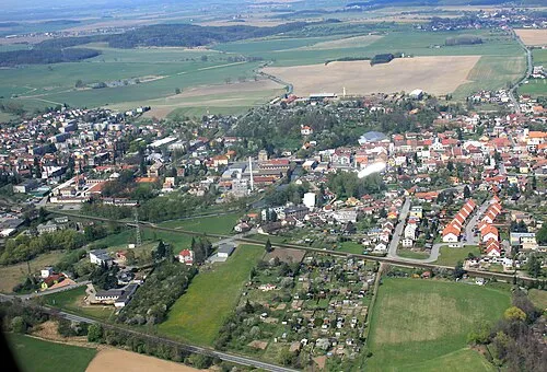
Josefov is a village. Location: Jaroměř, Náchod District. Population: 7,015. Elevation: 275 m.
Josefov Fortress (Czech: Pevnost Josefov, German: Josefstadt or Josephstadt) is a large historic defence complex of 18th-century military architecture in Jaroměř in the Hradec Králové Region of the Czech Republic. It was built between 1780 and 1787. Together with Terezín fortress, it was built for protection against attacks from Prussia, but its military importance, like other such fortresses built across Europe, was minimal as decisive battles were often fought elsewhere.
Source: Wikipedia · CC BY-SA 4.0
At a glance
- Area
- 2.9 km²
Source: Wikidata
Photos of Josefov
-

Fry72 · CC BY-SA 4.0

Population of Josefov over time
| 1900 | 6,127 | |
|---|---|---|
| 1910 | 5,438 | |
| 1921 | 5,809 | |
| 1930 | 7,015 | |
| 1950 | 4,156 | |
| 1961 | 3,595 | |
| 1970 | 3,196 | |
| 1980 | 2,934 | |
| 1991 | 2,298 | |
| 2001 | 2,690 | |
| 2011 | 2,688 | |
| 2021 | 2,443 |
Censuses and official estimates; source: Wikidata.
Climate of Josefov
Best months for sightseeingBest months for sightseeing: June–August.
This month · November
A cold month
Day 6° · Night 1° · Rain 35 mm
- Hottest month
- August (day 23°)
- Coldest month
- January (night -5°)
- Wettest month
- July (82 mm)
- Driest month
- February (23 mm)
Bars: average monthly low and high temperature. Below: precipitation. Monthly averages for 1970–2000 at about 18 km resolution, adjusted for elevation. Highlighted months are mild and relatively dry. Source: WorldClim 2.1 (CC BY 4.0).
Show values as a table
| Month | Jan | Feb | Mar | Apr | May | Jun | Jul | Aug | Sep | Oct | Nov | Dec |
|---|---|---|---|---|---|---|---|---|---|---|---|---|
| Average high (°C) | 0° | 2° | 7° | 13° | 18° | 21° | 23° | 23° | 18° | 13° | 6° | 2° |
| Average low (°C) | -5° | -4° | 0° | 3° | 7° | 11° | 12° | 12° | 9° | 5° | 1° | -3° |
| Precipitation (mm) | 24 | 23 | 29 | 37 | 60 | 77 | 82 | 68 | 44 | 36 | 35 | 31 |
How to get to Josefov
The nearest airport is Pardubice Airport (PED), 39 km to the south as the crow flies. The nearest large city is Prague, 111 km to the west.
Airports
- Pardubice Airport (PED) Pardubice 39 kmsouth
- Copernicus Wrocław Airport (WRO) Wrocław 108 kmnortheast
- Václav Havel Airport Prague (PRG) Prague 122 kmwest
Nearby large cities
- Prague Population: 1.2M 111 kmwest
- Brno Population: 404.3K 136 kmsouth
- Dresden Population: 564.9K 174 kmnorthwest
- Chemnitz Population: 247.2K 220 kmwest
- Linz Population: 204.8K 256 kmsouthwest
Straight-line distances; road distances are longer. Airport data: OurAirports.
Day trips from Josefov
Within 100 km: 54 historic and cultural sites, 573 natural sites.
0–25 km3 places
- Kolčarka Mountain 25 kmNE
- Turek Mountain 13 kmS
- Bausnitz Concentration Camp Historic site 24 kmN
25–60 km308 places
- Tvarožník Mountain 58 kmNW
- Bielec Mountain 54 kmN
- Parkowa Mountain 53 kmN
- Ptak Mountain 33 kmNE
60–100 km316 places
- Lysá Mountain 83 kmW
- Sucha Kopa Mountain 72 kmE
- Jastrzębiec Mountain 67 kmNW
- Goworek Mountain 65 kmE
Straight-line distances.
Nearby attractions & nature
Everything nearby-
 Turek Mountain, Jeníkovice13 km S
-
Kolčarka Mountain, Malé Svatoňovice25 km NE
-
Bausnitz Concentration Camp Historic site, Trutnov24 km N
Sources & licences
Data last updated: · 2 independent sources