Petrovský vrch
Located in Petrov nad Desnou, Šumperk District Coordinates: 49°59′39″ N 17°04′18″ E
- Elevation
- 778 m
- above sea level
- Local time
- UTC+01:00
- Europe/Prague · UTC+01:00
- Airports
- OSR Leoš Janáček Airport Ostrava82 km
- PED Pardubice Airport95 km
About Petrovský vrch
Petrovský vrch is a mountain. Location: Petrov nad Desnou, Šumperk District. Elevation: 778 m. The best months to visit are June–August. The nearest airport is Leoš Janáček Airport Ostrava (82 km). Nearby sights include Prostřední skála and Kamenný vrch.
At a glance
- Topographic prominence
- 160 m
Source: Wikidata
Photos of Petrovský vrch
-
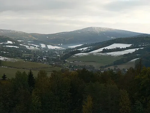
Kamenný vrch Martin Vavrik · Public domain

Climate of Petrovský vrch
Best months for sightseeingBest months for sightseeing: June–August.
This month · November
A cold month
Day 3° · Night -3° · Rain 41 mm
- Hottest month
- July (day 20°)
- Coldest month
- January (night -7°)
- Wettest month
- June (94 mm)
- Driest month
- February (28 mm)
Bars: average monthly low and high temperature. Below: precipitation. Monthly averages for 1970–2000 at about 18 km resolution, adjusted for elevation. Highlighted months are mild and relatively dry. Source: WorldClim 2.1 (CC BY 4.0).
Show values as a table
| Month | Jan | Feb | Mar | Apr | May | Jun | Jul | Aug | Sep | Oct | Nov | Dec |
|---|---|---|---|---|---|---|---|---|---|---|---|---|
| Average high (°C) | -2° | -1° | 4° | 9° | 15° | 18° | 20° | 19° | 15° | 9° | 3° | -1° |
| Average low (°C) | -7° | -7° | -3° | 0° | 5° | 8° | 9° | 9° | 6° | 2° | -3° | -6° |
| Precipitation (mm) | 29 | 28 | 31 | 40 | 68 | 94 | 88 | 81 | 55 | 41 | 41 | 37 |
How to get to Petrovský vrch
The nearest airport is Leoš Janáček Airport Ostrava (OSR), 82 km to the southeast as the crow flies. The nearest large city is Brno, 95 km to the south.
Airports
- Leoš Janáček Airport Ostrava (OSR) Mošnov 82 kmsoutheast
- Pardubice Airport (PED) Pardubice 95 kmwest
- Brno-Tuřany Airport (BRQ) Brno 98 kmsouth
Nearby large cities
- Brno Population: 404.3K 95 kmsouth
- Prague Population: 1.2M 190 kmwest
- Bratislava Population: 423.7K 205 kmsouth
- Győr Population: 129.3K 260 kmsouth
- Dresden Population: 564.9K 264 kmnorthwest
Straight-line distances; road distances are longer. Airport data: OurAirports.
Day trips from Petrovský vrch
Within 100 km: 34 historic and cultural sites, 501 natural sites.
0–25 km65 places
- Vysoká hole Mountain 13 kmNE
- Trlina Mountain 16 kmSW
- Špičák Mountain 12 kmSE
- Soukenná Mountain 12 kmE
25–60 km204 places
- Sucha Kopa Mountain 30 kmN
- Úsobrnka Natural site 51 kmSW
- Goworek Mountain 29 kmNW
- Kłobuk Mountain 57 kmNW
60–100 km266 places
- Křížový Mountain 95 kmSE
- Ptak Mountain 74 kmNW
- Leszek Mountain 64 kmNW
- Klimek Mountain 65 kmNW
Straight-line distances.
Nearest towns and villages


Nearby attractions & nature
Everything nearby-
Prostřední skála Mountain, Vikýřovice1.4 km SW
-
Kamenný vrch Mountain, Nový Malín4 km SE
-
Kamenitý kopec Mountain, Velké Losiny3.7 km N
-
Smrčník Mountain, Oskava4.9 km SE
-
Volyň Mountain, Oskava5.3 km S
-
Holubí vrch Mountain, Šumperk5.9 km W
-
Kopka Mountain, Nový Malín6 km S
-
U Kapličky Mountain, Šumperk6.5 km W
Sources & licences
Data last updated: · 2 independent sources