- Elevation
- 665 m
- above sea level
- Local time
- UTC+01:00
- Europe/Prague · UTC+01:00
- Airports
- PED Pardubice Airport74 km
- BRQ Brno-Tuřany Airport88 km
About Vysoká
Vysoká is a mountain. Location: Jihlava, Okres Jihlava. Elevation: 665 m. The best months to visit are June–August. The nearest airport is Pardubice Airport (74 km). Nearby sights include Kostelecký vrch and Na Hosovském kopci.
Photos of Vysoká
-
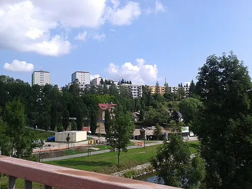
Královský vršek Jana Lánová · CC BY-SA 4.0 -
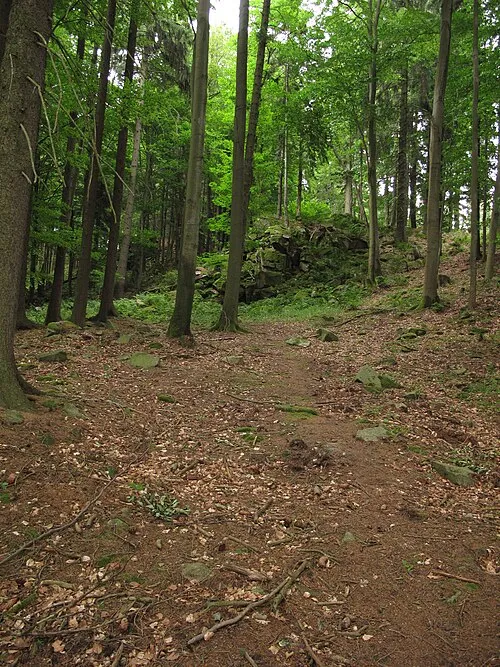
Přední skála Juandev · CC BY-SA 3.0


Climate of Vysoká
Best months for sightseeingBest months for sightseeing: June–August.
This month · November
A cold month
Day 4° · Night -1° · Rain 39 mm
- Hottest month
- August (day 22°)
- Coldest month
- January (night -6°)
- Wettest month
- June (83 mm)
- Driest month
- February (26 mm)
Bars: average monthly low and high temperature. Below: precipitation. Monthly averages for 1970–2000 at about 18 km resolution, adjusted for elevation. Highlighted months are mild and relatively dry. Source: WorldClim 2.1 (CC BY 4.0).
Show values as a table
| Month | Jan | Feb | Mar | Apr | May | Jun | Jul | Aug | Sep | Oct | Nov | Dec |
|---|---|---|---|---|---|---|---|---|---|---|---|---|
| Average high (°C) | -1° | 1° | 6° | 11° | 17° | 19° | 21° | 22° | 16° | 11° | 4° | 0° |
| Average low (°C) | -6° | -5° | -2° | 1° | 6° | 9° | 10° | 10° | 7° | 3° | -1° | -5° |
| Precipitation (mm) | 27 | 26 | 33 | 42 | 64 | 83 | 82 | 67 | 46 | 34 | 39 | 33 |
How to get to Vysoká
The nearest airport is Pardubice Airport (PED), 74 km to the north as the crow flies. The nearest large city is Brno, 81 km to the east.
Airports
- Pardubice Airport (PED) Pardubice 74 kmnorth
- Brno-Tuřany Airport (BRQ) Brno 88 kmeast
- České Budějovice South Bohemian Airport (JCL) České Budějovice 93 kmsouthwest
Nearby large cities
- Brno Population: 404.3K 81 kmeast
- Prague Population: 1.2M 113 kmnorthwest
- Linz Population: 204.8K 149 kmsouthwest
- Bratislava Population: 423.7K 178 kmsoutheast
- Dresden Population: 564.9K 227 kmnorthwest
Straight-line distances; road distances are longer. Airport data: OurAirports.
Day trips from Vysoká
Within 100 km: 68 historic and cultural sites, 1,034 natural sites, 192 lakes, rivers and coasts.
0–25 km177 places
- Královský vršek Mountain 7 kmNE
- Seč Mountain 24 kmS
- U Svatého Antonína Mountain 6 kmNW
- Špičák Mountain 23 kmNW
25–60 km346 places
- Kranbühel Mountain 57 kmS
- Dunkelkopf Mountain 59 kmS
- Galgenberg Mountain 56 kmS
- Kreuzberg Mountain 60 kmS
60–100 km771 places
- Hutbühel Mountain 60 kmSW
- Geißbühel Mountain 61 kmS
- Steinberg Mountain 64 kmS
- Spielberg Mountain 99 kmS
Straight-line distances.
Nearest towns and villages


Nearby attractions & nature
Everything nearby-
Kostelecký vrch Mountain, Kostelec1.8 km SW
-
Na Hosovském kopci Mountain, Jihlava1.9 km N
-
Korunní kopec Mountain, Jihlava1.9 km S
-
Popický vrch Mountain, Třešť2.6 km S
-
Popický vršek Mountain, Třešť2.6 km SW
-
Vodárenský vrch Mountain, Jihlava2.7 km NE
-
Hosovský vrch Mountain, Jihlava2.8 km N
-
Bradlo Mountain, Jihlava2.8 km NW
More nature in Czechia
-
Královský vršek Mountain, Jihlava6.9 km NE
-
Bradelský vrch Mountain, Jihlava3.6 km N
-
Větrník Mountain, Jihlava4.1 km NE
-
Lysá Mountain, Jihlava4.4 km N
-
Na Skalce Mountain, Jihlava4.8 km NE
-
Na Brněnské vyhlídce Mountain, Jihlava7.4 km E
Sources & licences
Data last updated: · 2 independent sources