- Elevation
- 540 m
- above sea level
- Local time
- UTC+01:00
- Europe/Prague · UTC+01:00
- Airports
- OSR Leoš Janáček Airport Ostrava63 km
- BRQ Brno-Tuřany Airport80 km
About Tutkova
Tutkova is a mountain. Location: Horní Lhota, Zlín District. Elevation: 540 m. The best months to visit are June–August. The nearest airport is Leoš Janáček Airport Ostrava (63 km). Nearby sights include Komonec [Provodov na Moravě] and Drdol.
Photos of Tutkova
-
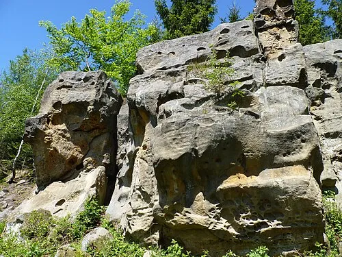
Vizovické vrchy Michal Klajban · CC BY-SA 3.0

Climate of Tutkova
Best months for sightseeingBest months for sightseeing: June–August.
This month · November
A cold month
Day 5° · Night -1° · Rain 49 mm
- Hottest month
- July (day 22°)
- Coldest month
- January (night -6°)
- Wettest month
- June (98 mm)
- Driest month
- January (32 mm)
Bars: average monthly low and high temperature. Below: precipitation. Monthly averages for 1970–2000 at about 18 km resolution, adjusted for elevation. Highlighted months are mild and relatively dry. Source: WorldClim 2.1 (CC BY 4.0).
Show values as a table
| Month | Jan | Feb | Mar | Apr | May | Jun | Jul | Aug | Sep | Oct | Nov | Dec |
|---|---|---|---|---|---|---|---|---|---|---|---|---|
| Average high (°C) | 0° | 1° | 6° | 11° | 17° | 20° | 22° | 22° | 17° | 11° | 5° | 1° |
| Average low (°C) | -6° | -5° | -2° | 2° | 6° | 9° | 11° | 11° | 7° | 3° | -1° | -4° |
| Precipitation (mm) | 32 | 32 | 34 | 48 | 76 | 98 | 87 | 84 | 62 | 44 | 49 | 45 |
How to get to Tutkova
The nearest airport is Leoš Janáček Airport Ostrava (OSR), 63 km to the north as the crow flies. The nearest large city is Brno, 87 km to the west.
Airports
- Leoš Janáček Airport Ostrava (OSR) Mošnov 63 kmnorth
- Brno-Tuřany Airport (BRQ) Brno 80 kmwest
- Sliač Airport (SLD) Sliač 115 kmsoutheast
Nearby large cities
- Brno Population: 404.3K 87 kmwest
- Bratislava Population: 423.7K 125 kmsouthwest
- Győr Population: 129.3K 166 kmsouth
- Székesfehérvár Population: 101.6K 225 kmsouth
- Miskolc Population: 154.5K 250 kmsoutheast
Straight-line distances; road distances are longer. Airport data: OurAirports.
Day trips from Tutkova
Within 100 km: 20 historic and cultural sites, 374 natural sites, 27 lakes, rivers and coasts.
0–25 km38 places
- Křížový Mountain 22 kmNE
- Bílé Karpaty Mountain 24 kmSE
- Holý vrch Mountain 23 kmSE
- Kaňur Mountain 25 kmE
25–60 km89 places
- Strážov Mountain 54 kmSE
- Chvojnica River 60 kmSW
- Zřícenina Tematín Historic site 55 kmS
- Strčí Hlava Mountain 26 kmE
60–100 km294 places
- Korňa River 66 kmNE
- Veľký Kriváň Mountain 90 kmE
- Tríbeč Mountain 91 kmS
- Tlstá Mountain 90 kmE
Straight-line distances.
Nearest towns and villages
-
Horní Lhota Village, Horní Lhota2 km S
-
Sehradice Village, Sehradice3.7 km SE
-
Dolní Lhota Village, Dolní Lhota4 km S
-
Slopné Village, Slopné4.1 km E
-
Podhradí Village, Podhradí3.8 km SW
-
Provodov Village, Provodov4.4 km W
Nearby attractions & nature
Everything nearby-
Komonec [Provodov na Moravě] Mountain, Provodov2.2 km SW
-
Drdol Mountain, Želechovice nad Dřevnicí2.5 km NW
-
Dúbrava Mountain, Loučka5.9 km E
-
Kamenec Mountain, Březůvky7.4 km W
-
Vizovické vrchy Mountain, Czechia7.3 km W
-
Suchý vrch [Újezd u Valašských Klobouk] Mountain, Vysoké Pole8.7 km E
-
Kriby Mountain, Zlín9.3 km W
-
Losky Mountain, Bohuslavice u Zlína11 km W
Sources & licences
Data last updated: · 2 independent sources