Nørre Åby
Located in Middelfart Kommune, Region South Denmark Coordinates: 55°27′40″ N 9°52′46″ E
- Population
- 3,129
- 3.1K
- Elevation
- 23 m
- above sea level
- Local time
- UTC+01:00
- Europe/Copenhagen · UTC+01:00
- Airports
- ODE Odense Hans Christian Andersen Airport28 km
- BLL Billund Airport55 km
About Nørre Åby
Nørre Åby is a village. Location: Middelfart Kommune, Region South Denmark. Population: 3,129. Elevation: 23 m.
Nørre Aaby is a town in central Denmark, located in Middelfart Municipality on the island of Funen. Until Kommunalreformen ("The Municipality Reform" of 2007) it was the site of the municipal council of the now former Nørre Aaby Municipality. The town is most known for the great number of efterskoler located around the town: Viby Efterskole, Båring Efterskole, Vesterdal Efterskole, Nørre Åby Efterskole and Eisbjerghus Efterskole. The population of Nørre Aaby is 3,129 (1 January 2026).
Source: Wikipedia · CC BY-SA 4.0
Climate of Nørre Åby
Best months for sightseeingBest months for sightseeing: June–August.
This month · November
A cold month
Day 8° · Night 3° · Rain 67 mm
- Hottest month
- August (day 20°)
- Coldest month
- February (night -3°)
- Wettest month
- November (67 mm)
- Driest month
- February (35 mm)
Bars: average monthly low and high temperature. Below: precipitation. Monthly averages for 1970–2000 at about 18 km resolution, adjusted for elevation. Highlighted months are mild and relatively dry. Source: WorldClim 2.1 (CC BY 4.0).
Show values as a table
| Month | Jan | Feb | Mar | Apr | May | Jun | Jul | Aug | Sep | Oct | Nov | Dec |
|---|---|---|---|---|---|---|---|---|---|---|---|---|
| Average high (°C) | 4° | 4° | 6° | 10° | 15° | 18° | 20° | 20° | 17° | 12° | 8° | 5° |
| Average low (°C) | -3° | -3° | -1° | 3° | 7° | 11° | 13° | 12° | 10° | 6° | 3° | 0° |
| Precipitation (mm) | 52 | 35 | 42 | 37 | 45 | 53 | 61 | 62 | 61 | 66 | 67 | 58 |
How to get to Nørre Åby
The nearest airport is Odense Hans Christian Andersen Airport (ODE), 28 km to the east as the crow flies. The nearest large city is Odense, 33 km to the east.
Airports
- Odense Hans Christian Andersen Airport (ODE) Odense 28 kmeast
- Billund Airport (BLL) Billund 55 kmnorthwest
- Sønderborg Airport (SGD) Sønderborg 56 kmsouth
Nearby large cities
- Odense Population: 180.9K 33 kmeast
- Aarhus Population: 285.3K 80 kmnorth
- Kiel Population: 252.7K 128 kmsouth
- Copenhagen Population: 1.2M 171 kmeast
- Aalborg Population: 142.9K 177 kmnorth
Straight-line distances; road distances are longer. Airport data: OurAirports.
Day trips from Nørre Åby
Within 100 km: 33 historic and cultural sites, 273 natural sites, 146 lakes, rivers and coasts.
0–25 km15 places
- Linderum Island 22 kmSW
- Dræet Island 24 kmNE
- Bastholm Island 21 kmS
- Græsholm Island 20 kmS
25–60 km87 places
- Als Island 53 kmS
- Taksensand Beach 51 kmS
- Rævshalen Beach 35 kmSW
- Flovt Strand Beach 29 kmSW
60–100 km350 places
- Tåsinge Island 69 kmSE
- Aeroe Island 71 kmSE
- Fanø Island 93 kmW
- Rindby Strand Beach 95 kmW
Straight-line distances.
Nearby attractions & nature
Everything nearby-
Svinø Natural site, Middelfart Kommune5.6 km W
-
Fluebjerg Mountain, Middelfart Kommune5.6 km SE
-
Røjle Banke Mountain, Middelfart Kommune8.6 km N
-
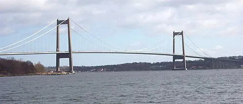 Little Belt Bridge Landmark, Region South Denmark10 km NW
-
Dræet Island, Nordfyns Kommune24 km NE
-
Store Øksnebjerg Mountain, Assens Kommune23 km S
Sources & licences
Data last updated: · 2 independent sources