
- Population
- 1,109,232
- 1.1M
- Elevation
- 49 m
- above sea level
- Local time
- UTC+01:00
- Europe/Paris · UTC+01:00
- Places inside
- 84
- listed under Ille-et-Vilaine
- Airports
- RNS Rennes-Saint-Jacques Airport21 km
- NTE Nantes Atlantique Airport113 km
About Ille-et-Vilaine
Ille-et-Vilaine is a district. Location: Brittany Region, France. Population: 1,109,232.
Ille-et-Vilaine (French: [il e vilɛn] ; Gallo: Ill-e-Vilaenn; Breton: Il-ha-Gwilen; lit. 'Ille and Vilaine') is a department of France, located in the Brittany region in the northwest of the country. It is named after its two main rivers, the Ille and the Vilaine. Its prefecture is Rennes, with subprefectures in Fougères, Redon and Saint-Malo. It had a population of 1,120,666 in 2023.
Source: Wikipedia · CC BY-SA 4.0
Photos of Ille-et-Vilaine
-
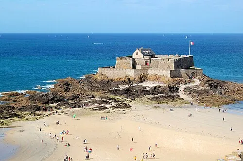
Fort National Pline · CC BY-SA 3.0

Travel notes for Ille-et-Vilaine
From Wikivoyage
Ille-et-Vilaine is the eastern-most department in Brittany, centred on the city of Rennes. It is named after two rivers, the Ille and the Vilaine, which meet in Rennes.
Get in+
Rennes has the best transportation connections in the department, including an international airport that serves budget airlines, and an hourly train connection from Paris Montparnasse.
Rennes Bretagne Airport (Rennes–Saint-Jacques Airport, Aéroport de Rennes–Saint-Jacques, RNS IATA) in a minor international airport with direct flights from numerous French cities, Ireland, the United Kingdom and Spain.
Source: Wikivoyage · CC BY-SA 4.0 · abridged
Places bordering Ille-et-Vilaine
- Manche
- Côtes-d'Armor
- Morbihan
- Loire-Atlantique
- Maine-et-Loire
- Mayenne department
Population of Ille-et-Vilaine over time
| 2012 | 1,007,901 | |
|---|---|---|
| 2015 | 1,042,884 | |
| 2017 | 1,060,199 | |
| 2018 | 1,069,228 | |
| 2019 | 1,079,498 | |
| 2020 | 1,088,855 | |
| 2021 | 1,098,325 | |
| 2022 | 1,109,232 | |
| 2023 | 1,120,666 |
Censuses and official estimates; source: Wikidata.
Climate of Ille-et-Vilaine
Best months for sightseeingBest months for sightseeing: June–September.
This month · November
A cold month
Day 12° · Night 5° · Rain 85 mm
- Hottest month
- August (day 23°)
- Coldest month
- February (night 2°)
- Wettest month
- November (85 mm)
- Driest month
- July (45 mm)
Bars: average monthly low and high temperature. Below: precipitation. Monthly averages for 1970–2000 at about 18 km resolution, adjusted for elevation. Highlighted months are mild and relatively dry. Source: WorldClim 2.1 (CC BY 4.0).
Show values as a table
| Month | Jan | Feb | Mar | Apr | May | Jun | Jul | Aug | Sep | Oct | Nov | Dec |
|---|---|---|---|---|---|---|---|---|---|---|---|---|
| Average high (°C) | 8° | 9° | 12° | 14° | 18° | 21° | 23° | 23° | 21° | 16° | 12° | 9° |
| Average low (°C) | 3° | 2° | 4° | 5° | 9° | 11° | 13° | 13° | 11° | 8° | 5° | 3° |
| Precipitation (mm) | 71 | 59 | 56 | 54 | 67 | 48 | 45 | 51 | 58 | 74 | 85 | 72 |
Other places to visit in this season: June July August September
How to get to Ille-et-Vilaine
The nearest airport is Rennes-Saint-Jacques Airport (RNS), 21 km to the southwest as the crow flies. For international flights: Nantes Atlantique Airport (NTE) (113 km). The nearest large city is Rennes, 14 km to the southwest.
Airports
- Rennes-Saint-Jacques Airport (RNS) Saint-Jacques-de-la-Lande, Ille-et-Vilaine 21 kmsouthwest
- Nantes Atlantique Airport (NTE) Nantes 113 kmsouth
- Jersey Airport (JER) St. Peter 127 kmnorthwest
Nearby large cities
- Rennes Population: 227.8K 14 kmsouthwest
- Angers Population: 168.3K 105 kmsoutheast
- Nantes Population: 325.1K 106 kmsouth
- Le Mans Population: 144.5K 128 kmeast
- Caen Population: 110.6K 141 kmnortheast
Straight-line distances; road distances are longer. Airport data: OurAirports.
Day trips from Ille-et-Vilaine
Within 100 km: 151 historic and cultural sites, 130 natural sites, 194 lakes, rivers and coasts.
0–25 km47 places
- Étang de Daniel Lake 19 kmSE
- Étang de Chevré Lake 5 kmNE
- Étang de Châtillon Lake 25 kmE
- Étang de Boulet Lake 22 kmNW
25–60 km148 places
- Mont-Saint-Michel Beach 52 kmN
- Étang de Trémigon Lake 37 kmNW
- Étang de Trémelin Lake 40 kmW
- Étang de la Taberge Lake 54 kmSW
60–100 km280 places
- Plage du Mole Beach 66 kmNW
- Plage de l'Éventail Beach 66 kmNW
- Plage Verger Beach 65 kmNW
- Île des Rimains Island 62 kmNW
Straight-line distances.
Places in Ille-et-Vilaine
84 placesLakes, rivers & coasts24
- Molène · River
- Nanson · River
- Pérouse · River
- Ruisseau de Canut · River
- Ruisseau de Canut · River
- Ruisseau de Cocane · River
- Ruisseau de Gras · River
- Ruisseau de Hodeille · River
- Ruisseau de la Chaise · River
- Ruisseau de la Chalouzais · River
- Ruisseau de Tréfneu · River
- Ruisseau d'Ise · River
- Ruisseau du Biez Jean · River
- Ruisseau du Désert · River
- Ruisseau du Passoir · River
- Ruisseau du Pont au Roux · River
- Ruisseau le Blosne · River
- Ruisseau le Guioult · River
- Seiche · River
- Semnon · River
- Serein · River
- Tronçon · River
- Veuvre · River
- Yaigne · River
Nature and heritage in Ille-et-Vilaine
Other regions in Brittany Region
-
 Morbihan District, Brittany Region102 km W
-
 Côtes-d'Armor District, Brittany Region97 km W
Sources & licences
Data last updated: · 2 independent sources