- Population
- 95,691
- 95.7K
- Elevation
- 334 m
- above sea level
- Local time
- UTC+01:00
- Europe/Paris · UTC+01:00
- Places inside
- 83
- listed under Arrondissement of Sarreguemines
- Airports
- SCN Saarbrücken Airport19 km
- SXB Strasbourg Airport65 km
About Arrondissement of Sarreguemines
Arrondissement of Sarreguemines is a municipality. Location: Moselle, Grand Est. Population: 95,691. Elevation: 334 m. The best months to visit are June–August. The nearest airport is Saarbrücken Airport (19 km). Nearby sights include Fort Casso and Forêt Domaniale de Lemberg.
Climate of Arrondissement of Sarreguemines
Best months for sightseeingBest months for sightseeing: June–August.
This month · November
A cold month
Day 7° · Night 1° · Rain 86 mm
- Hottest month
- July (day 23°)
- Coldest month
- January (night -2°)
- Wettest month
- December (96 mm)
- Driest month
- April (58 mm)
Bars: average monthly low and high temperature. Below: precipitation. Monthly averages for 1970–2000 at about 18 km resolution, adjusted for elevation. Highlighted months are mild and relatively dry. Source: WorldClim 2.1 (CC BY 4.0).
Show values as a table
| Month | Jan | Feb | Mar | Apr | May | Jun | Jul | Aug | Sep | Oct | Nov | Dec |
|---|---|---|---|---|---|---|---|---|---|---|---|---|
| Average high (°C) | 3° | 5° | 9° | 13° | 18° | 21° | 23° | 23° | 19° | 13° | 7° | 4° |
| Average low (°C) | -2° | -2° | 1° | 3° | 7° | 10° | 12° | 12° | 8° | 5° | 1° | -1° |
| Precipitation (mm) | 75 | 69 | 68 | 58 | 78 | 79 | 73 | 60 | 68 | 82 | 86 | 96 |
How to get to Arrondissement of Sarreguemines
The nearest airport is Saarbrücken Airport (SCN), 19 km to the northwest as the crow flies. For international flights: Strasbourg Airport (SXB) (65 km). The nearest large city is Saarbrücken, 25 km to the northwest.
Airports
- Saarbrücken Airport (SCN) Saarbrücken 19 kmnorthwest
- Strasbourg Airport (SXB) Strasbourg 65 kmsoutheast
- Karlsruhe Baden-Baden Airport (FKB) Rheinmünster 70 kmsoutheast
Nearby large cities
- Saarbrücken Population: 183K 25 kmnorthwest
- Strasbourg Population: 274.8K 65 kmsoutheast
- Metz Population: 123.9K 78 kmwest
- Karlsruhe Population: 283.8K 86 kmeast
- Nancy Population: 105.1K 88 kmsouthwest
Straight-line distances; road distances are longer. Airport data: OurAirports.
Day trips from Arrondissement of Sarreguemines
Within 100 km: 428 historic and cultural sites, 2,421 natural sites, 567 lakes, rivers and coasts.
0–25 km212 places
- Sonnenberg Mountain 23 kmNW
- Kahler Berg Mountain 15 kmN
- Kahlenberg Mountain 13 kmNE
- Hochscheid Mountain 22 kmN
25–60 km1,229 places
- Gelterswoog Lake 49 kmNE
- Bostalsee Lake 57 kmN
- Ottweiler Wingertsweier Lake 39 kmN
- Bomberg Mountain 43 kmN
60–100 km1,975 places
- Sauer River 91 kmNW
- Unditz River 83 kmSE
- Rench River 69 kmSE
- Insel Flotzgrün Island 91 kmE
Straight-line distances.
Arrondissement of Sarreguemines and similar cities
Side by side with cities of similar size in the same country: population, elevation and climate.
| Measure | Arrondissement of Sarreguemines | Argenteuil | Avignon | Nancy |
|---|---|---|---|---|
| Population | 95.7K | 101.5K | 89.8K | 105.1K |
| Elevation | 334 m | 37 m | 31 m | 212 m |
| Summer day (hottest month) | 23° | 25° | 31° | 24° |
| Winter night (coldest month) | -2° | 2° | 2° | -1° |
| Annual rainfall | 892 mm | 632 mm | 765 mm | 789 mm |
| Best months | Jun–Aug | May–Sep | May–Jun, Sep | Jun–Sep |
| Distance | — | 365 km | 599 km | 88 km |
Climate values are 1970–2000 monthly averages; straight-line distance.
Places in Arrondissement of Sarreguemines
83 places- 1 Sarreguemines 20.9K
- 2 Bitche 5.2K
- 3 Sarralbe 4.6K
- 4 Grosbliederstroff 3.3K
- 5 Woustviller 3.2K
- 6 Puttelange-aux-Lacs 3K
- 7 Hambach 2.9K
- 8 Rohrbach-lès-Bitche 2.3K
- 9 Rouhling 2.1K
- 10 Montbronn 1.6K
- 11 Goetzenbruck 1.6K
- 12 Willerwald 1.5K
- 13 Petit-Réderching 1.5K
- 14 Lemberg 1.5K
- 15 Neufgrange 1.4K
- 16 Rémelfing 1.4K
- 17 Hundling 1.3K
- 18 Gros-Réderching 1.3K
- 19 Holving 1.3K
- 20 Sarreinsming 1.3K
- 21 Enchenberg 1.3K
- 22 Bining 1.2K
- 23 Rémering-lès-Puttelange 1.1K
- 24 Soucht 1.1K
- 25 Bliesbruck 1K
- 26 Achen 1K
- 27 Wiesviller 987
- 28 Saint-Jean-Rohrbach 979
- 29 Loupershouse 941
- 30 Lixing-lès-Rouhling 927
- 31 Hilsprich 873
- 32 Le Val-de-Guéblange 860
- 33 Kalhausen 853
- 34 Bettviller 840
- 35 Zetting 833
- 36 Volmunster 802
- 37 Wittring 793
- 38 Baerenthal 777
- 39 Rahling 768
- 40 Ippling 761
- 41 Etting 756
- 42 Wœlfling-lès-Sarreguemines 750
- 43 Meisenthal 702
- 44 Grundviller 670
- 45 Siersthal 669
- 46 Blies-Ébersing 660
- 47 Rimling 632
- 48 Blies-Guersviller 630
- 49 Philippsbourg 616
- 50 Frauenberg 575
- 51 Epping 567
- 52 Schorbach 541
- 53 Hottviller 529
- 54 Lambach 512
- 55 Ernestviller 501
- 56 Saint-Louis-lès-Bitche 499
- 57 Walschbronn 498
- 58 Éguelshardt 428
- 59 Guebenhouse 427
- 60 Erching 407
Bar: population relative to the most populous place in this list.
Nearby attractions & nature
Everything nearby-
Fort Casso Historic site, Grand Est2.3 km E
-
Forêt Domaniale de Lemberg Natural site, Moselle8.4 km SE
-
Klosterwald Natural site, Saarland8.4 km N
-
Parc Archéologique Européen de Bliesbruck-Reinheim Natural site, Germany8 km NW
-
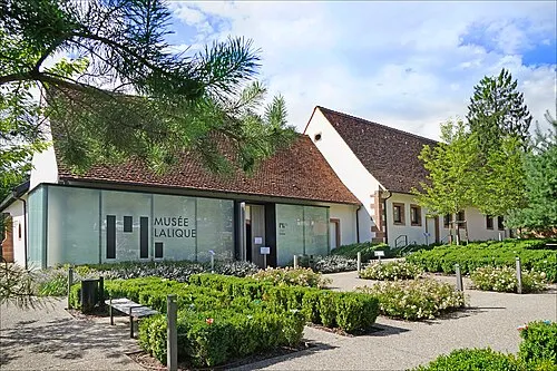 Musée Lalique Museum, Grand Est18 km SE
-
Ouvrage du Simserhof Historic site, Grand Est9.7 km E
-
Hanickel Mountain, Gersheim13 km N
-
Bannholz Natural site, Saarland10 km NW
Sources & licences
Data last updated: