Arrondissement of Compiègne
Located in Oise, Hauts-de-France Coordinates: 49°30′10″ N 2°53′00″ E
- Population
- 182,372
- 182.4K
- Elevation
- 128 m
- above sea level
- Local time
- UTC+01:00
- Europe/Paris · UTC+01:00
- Places inside
- 156
- listed under Arrondissement of Compiègne
- Airports
- BVA Beauvais-Tillé airport56 km
- CDG Charles de Gaulle International Airport60 km
About Arrondissement of Compiègne
Arrondissement of Compiègne is a municipality. Location: Oise, Hauts-de-France. Population: 182,372. Elevation: 128 m. The best months to visit are June–August. The nearest airport is Beauvais-Tillé airport (56 km). Nearby sights include Matz and Bois de Thiescourt.
Photos of Arrondissement of Compiègne
-
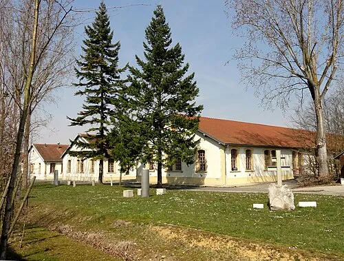
Police Custody Camp Compiègne P.poschadel · CC BY-SA 3.0

Climate of Arrondissement of Compiègne
Best months for sightseeingBest months for sightseeing: June–August.
This month · November
A cold month
Day 9° · Night 3° · Rain 56 mm
- Hottest month
- August (day 23°)
- Coldest month
- February (night 0°)
- Wettest month
- June (62 mm)
- Driest month
- February (45 mm)
Bars: average monthly low and high temperature. Below: precipitation. Monthly averages for 1970–2000 at about 18 km resolution, adjusted for elevation. Highlighted months are mild and relatively dry. Source: WorldClim 2.1 (CC BY 4.0).
Show values as a table
| Month | Jan | Feb | Mar | Apr | May | Jun | Jul | Aug | Sep | Oct | Nov | Dec |
|---|---|---|---|---|---|---|---|---|---|---|---|---|
| Average high (°C) | 5° | 6° | 10° | 13° | 17° | 20° | 23° | 23° | 19° | 14° | 9° | 6° |
| Average low (°C) | 0° | 0° | 2° | 4° | 8° | 10° | 12° | 12° | 10° | 7° | 3° | 1° |
| Precipitation (mm) | 53 | 45 | 50 | 46 | 58 | 62 | 54 | 49 | 55 | 58 | 56 | 60 |
How to get to Arrondissement of Compiègne
The nearest airport is Beauvais-Tillé airport (BVA), 56 km to the west as the crow flies. The nearest large city is Amiens, 61 km to the northwest.
Airports
- Beauvais-Tillé airport (BVA) Beauvais 56 kmwest
- Charles de Gaulle International Airport (CDG) Paris (Roissy-en-France, Val-d'Oise) 60 kmsouthwest
- Paris-Orly Airport (ORY) Paris (Orly, Val-de-Marne) 94 kmsouthwest
Nearby large cities
- Amiens Population: 143.1K 61 kmnorthwest
- Marne La Vallée Population: 318.3K 76 kmsouth
- Argenteuil Population: 101.5K 77 kmsouthwest
- Montreuil Population: 111.2K 78 kmsouthwest
- Cergy-Pontoise Population: 183.4K 78 kmsouthwest
Straight-line distances; road distances are longer. Airport data: OurAirports.
Day trips from Arrondissement of Compiègne
Within 100 km: 572 historic and cultural sites, 181 natural sites, 157 lakes, rivers and coasts.
0–25 km41 places
- Mont du Tremble Mountain 10 kmS
- Mont Saint-Marc Mountain 12 kmS
- Mont Ganelon Mountain 6 kmSW
- Bois de Thiescourt Natural site 5 kmNW
25–60 km157 places
- Étang de l'Épine Lake 46 kmSW
- Étang du Désert Lake 44 kmS
- Le Grand Vivier Lake 54 kmSW
- Mont Pagnotte Mountain 30 kmSW
60–100 km712 places
- Sensée River 87 kmN
- Île Saint-Louis Island 82 kmSW
- Île de la Cité Island 82 kmSW
- Île du Pont Island 82 kmSW
Straight-line distances.
Arrondissement of Compiègne and similar cities
Side by side with cities of similar size in the same country: population, elevation and climate.
| Measure | Arrondissement of Compiègne | Paris 18 Buttes-Montmartre | Cergy-Pontoise | Paris 13 Gobelins |
|---|---|---|---|---|
| Population | 182.4K | 183.1K | 183.4K | 181.3K |
| Elevation | 128 m | 66 m | 54 m | 63 m |
| Summer day (hottest month) | 23° | 25° | 24° | 25° |
| Winter night (coldest month) | 0° | 2° | 1° | 2° |
| Annual rainfall | 646 mm | 641 mm | 641 mm | 632 mm |
| Best months | Jun–Aug | May–Sep | Jun–Sep | May–Sep |
| Distance | — | 78 km | 78 km | 84 km |
Climate values are 1970–2000 monthly averages; straight-line distance.
Places in Arrondissement of Compiègne
156 places- 61 Bailly 643
- 62 Vieux-Moulin 642
- 63 Cuvilly 632
- 64 Jonquières 612
- 65 Beaulieu-les-Fontaines 611
- 66 Rivecourt 580
- 67 Gournay-sur-Aronde 576
- 68 Muirancourt 566
- 69 Armancourt 559
- 70 Suzoy 557
- 71 Francières 546
- 72 Giraumont 543
- 73 Appilly 537
- 74 Margny-sur-Matz 534
- 75 Lagny 530
- 76 Couloisy 528
- 77 Babœuf 526
- 78 Morlincourt 525
- 79 Orvillers-Sorel 525
- 80 Chelles 524
- 81 Caisnes 519
- 82 Cannectancourt 514
- 83 Larbroye 507
- 84 Marquéglise 504
- 85 Boulogne-la-Grasse 475
- 86 Pontoise-lès-Noyon 463
- 87 Roye-sur-Matz 460
- 88 Hémévillers 457
- 89 Bienville 455
- 90 Vignemont 433
- 91 Villeselve 416
- 92 Antheuil-Portes 412
- 93 Marest-sur-Matz 410
- 94 Brétigny 408
- 95 Dives 399
- 96 Canny-sur-Matz 391
- 97 Amy 389
- 98 Golancourt 387
- 99 Porquéricourt 386
- 100 Varesnes 371
- 101 Fréniches 349
- 102 Grandrû 342
- 103 Beaurains-lès-Noyon 337
- 104 Berlancourt 337
- 105 Hautefontaine 332
- 106 Bussy 325
- 107 Bitry 319
- 108 Genvry 318
- 109 Saint-Étienne-Roilaye 318
- 110 Nampcel 317
- 111 Saint-Jean-aux-Bois 316
- 112 Écuvilly 315
- 113 Candor 296
- 114 Ognolles 289
- 115 Passel 287
- 116 Ricquebourg 283
- 117 Neufvy-sur-Aronde 281
- 118 Vandélicourt 281
- 119 Vauchelles 273
- 120 Montmartin 259
Bar: population relative to the most populous place in this list.
Nearby attractions & nature
Everything nearby-
Matz River, Oise2.4 km SE
-
Bois de Thiescourt Natural site, Oise5.4 km NW
-
Forêt de Laigue Natural site, Oise6.3 km SE
-
Divette River, Oise8 km NE
-
Aisne River, Oise8.1 km S
-
Aronde River, Oise8.1 km S
-
Forêt d'Ourcamp Natural site, Oise9.1 km NE
-
Rû de Berne River, Oise10 km S
Sources & licences
Data last updated: