Averdoingt
Located in Arrondissement of Arras, Pas-de-Calais Coordinates: 50°20′40″ N 2°26′31″ E
- Population
- 291
- 291
- Elevation
- 149 m
- above sea level
- Local time
- UTC+01:00
- Europe/Paris · UTC+01:00
- Places inside
- 2
- listed under Averdoingt
- Airports
- LIL Lille Airport53 km
- OST Ostend-Bruges International Airport100 km
About Averdoingt
Averdoingt is a village. Location: Arrondissement of Arras, Pas-de-Calais. Population: 291. Elevation: 149 m. The best months to visit are June–August. The nearest airport is Lille Airport (53 km). Nearby sights include Canadian National Vimy Memorial and Parc du chàteau.
Climate of Averdoingt
Best months for sightseeingBest months for sightseeing: June–August.
This month · November
A cold month
Day 9° · Night 4° · Rain 76 mm
- Hottest month
- August (day 21°)
- Coldest month
- February (night 1°)
- Wettest month
- November (76 mm)
- Driest month
- February (47 mm)
Bars: average monthly low and high temperature. Below: precipitation. Monthly averages for 1970–2000 at about 18 km resolution, adjusted for elevation. Highlighted months are mild and relatively dry. Source: WorldClim 2.1 (CC BY 4.0).
Show values as a table
| Month | Jan | Feb | Mar | Apr | May | Jun | Jul | Aug | Sep | Oct | Nov | Dec |
|---|---|---|---|---|---|---|---|---|---|---|---|---|
| Average high (°C) | 5° | 6° | 9° | 12° | 16° | 18° | 21° | 21° | 18° | 14° | 9° | 6° |
| Average low (°C) | 1° | 1° | 3° | 4° | 8° | 10° | 12° | 12° | 10° | 7° | 4° | 2° |
| Precipitation (mm) | 60 | 47 | 55 | 50 | 57 | 63 | 58 | 55 | 68 | 70 | 76 | 69 |
How to get to Averdoingt
The nearest airport is Lille Airport (LIL), 53 km to the northeast as the crow flies. The nearest large city is Amiens, 50 km to the south.
Airports
- Lille Airport (LIL) Lesquin 53 kmnortheast
- Ostend-Bruges International Airport (OST) Oostende 100 kmnorth
- Beauvais-Tillé airport (BVA) Beauvais 102 kmsouth
Nearby large cities
- Amiens Population: 143.1K 50 kmsouth
- Lille Population: 238.7K 54 kmnortheast
- Bruges Population: 118.5K 111 kmnortheast
- Ghent Population: 265.1K 119 kmnortheast
- Saint Peters Population: 125.4K 135 kmnorthwest
Straight-line distances; road distances are longer. Airport data: OurAirports.
Day trips from Averdoingt
Within 100 km: 173 historic and cultural sites, 176 natural sites, 257 lakes, rivers and coasts.
0–25 km16 places
- Bois de Watron Natural site 18 kmS
- Bois de la Justice Natural site 25 kmSW
- Bois d'Habarcq Natural site 12 kmE
- Bois des Dames Natural site 20 kmNE
25–60 km172 places
- Rode Berg Mountain 53 kmNE
- Kemmelberg Mountain 56 kmNE
- Bois de Ploegsteert Natural site 54 kmNE
- Winterbeek River 57 kmN
60–100 km418 places
- Plage Saint-Gabriel Beach 66 kmW
- Plage de Fort-Mahon Beach 64 kmW
- Blankaart Lake 77 kmN
- Lac des Herbieres Lake 97 kmE
Straight-line distances.
Places in Averdoingt
2 placesBar: population relative to the most populous place in this list.
Cities & villages1
- Le Quesnel · Village
Nearby attractions & nature
Everything nearby-
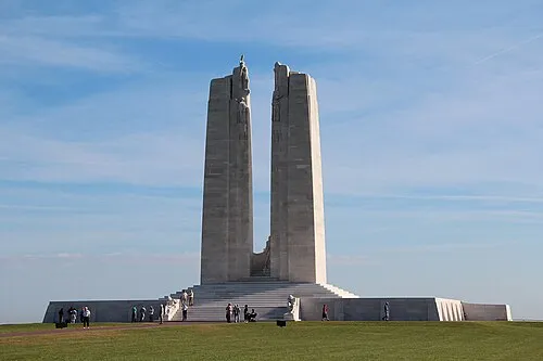 Canadian National Vimy Memorial Landmark, Givenchy-en-Gohelle24 km E
-
Parc du chàteau Natural site, Saint-Pol-sur-Ternoise8.4 km NW
-
Abbaye de Belval Attraction, Troisvaux9.5 km NW
-
Bois d'Habarcq Natural site, Hauts-de-France12 km E
-
Abbaye Notre-Dame de Cercamp Historic site, Frévent13 km SW
-
Abbaye Saint-Vaast d'Arras Historic site, Arras24 km E
Sources & licences
Data last updated: