Caucourt
Located in Arrondissement of Béthune, Pas-de-Calais Coordinates: 50°23′56″ N 2°34′17″ E
- Population
- 346
- 346
- Elevation
- 102 m
- above sea level
- Local time
- UTC+01:00
- Europe/Paris · UTC+01:00
- Places inside
- 1
- listed under Caucourt
- Airports
- LIL Lille Airport42 km
- OST Ostend-Bruges International Airport92 km
About Caucourt
Caucourt is a village. Location: Arrondissement of Béthune, Pas-de-Calais. Population: 346. Elevation: 102 m. The best months to visit are July–August. The nearest airport is Lille Airport (42 km). Nearby sights include Bouvigny-Boyeffles TV Mast and Canadian National Vimy Memorial.
Climate of Caucourt
Best months for sightseeingBest months for sightseeing: July–August.
This month · November
A cold month
Day 9° · Night 4° · Rain 73 mm
- Hottest month
- August (day 22°)
- Coldest month
- February (night 1°)
- Wettest month
- November (73 mm)
- Driest month
- February (46 mm)
Bars: average monthly low and high temperature. Below: precipitation. Monthly averages for 1970–2000 at about 18 km resolution, adjusted for elevation. Highlighted months are mild and relatively dry. Source: WorldClim 2.1 (CC BY 4.0).
Show values as a table
| Month | Jan | Feb | Mar | Apr | May | Jun | Jul | Aug | Sep | Oct | Nov | Dec |
|---|---|---|---|---|---|---|---|---|---|---|---|---|
| Average high (°C) | 6° | 6° | 10° | 12° | 16° | 19° | 22° | 22° | 19° | 14° | 9° | 7° |
| Average low (°C) | 1° | 1° | 3° | 4° | 8° | 11° | 13° | 13° | 10° | 7° | 4° | 2° |
| Precipitation (mm) | 58 | 46 | 54 | 49 | 58 | 64 | 58 | 54 | 66 | 68 | 73 | 67 |
How to get to Caucourt
The nearest airport is Lille Airport (LIL), 42 km to the northeast as the crow flies. The nearest large city is Lille, 43 km to the northeast.
Airports
- Lille Airport (LIL) Lesquin 42 kmnortheast
- Ostend-Bruges International Airport (OST) Oostende 92 kmnorth
- Beauvais-Tillé airport (BVA) Beauvais 110 kmsouth
Nearby large cities
- Lille Population: 238.7K 43 kmnortheast
- Amiens Population: 143.1K 59 kmsouth
- Bruges Population: 118.5K 101 kmnortheast
- Ghent Population: 265.1K 109 kmnortheast
- Anderlecht Population: 160.6K 133 kmeast
Straight-line distances; road distances are longer. Airport data: OurAirports.
Day trips from Caucourt
Within 100 km: 174 historic and cultural sites, 208 natural sites, 361 lakes, rivers and coasts.
0–25 km17 places
- Nave River 21 kmN
- Bois d'Habarcq Natural site 9 kmS
- Bois des Dames Natural site 12 kmN
- Parc du chàteau Natural site 17 kmW
25–60 km195 places
- Rode Berg Mountain 45 kmN
- Kemmelberg Mountain 46 kmN
- Bois de Rongy Natural site 58 kmE
- Polygoon van Zonnebeke Natural site 58 kmNE
60–100 km531 places
- Plage Saint-Gabriel Beach 73 kmW
- Plage de Fort-Mahon Beach 73 kmW
- Klein Strand Oostende Beach 96 kmN
- Blankaart Lake 68 kmN
Straight-line distances.
Places in Caucourt
1 placeBar: population relative to the most populous place in this list.
Nearby attractions & nature
Everything nearby-
Bouvigny-Boyeffles TV Mast Landmark, Bouvigny-Boyeffles6.2 km NE
-
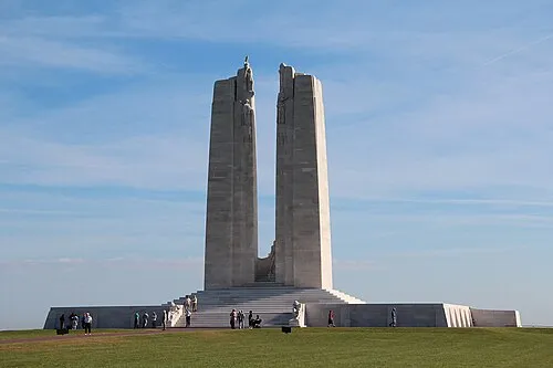 Canadian National Vimy Memorial Landmark, Givenchy-en-Gohelle15 km E
-
Bois d'Habarcq Natural site, Hauts-de-France8.6 km S
-
Bois des Dames Natural site, Hauts-de-France12 km N
-
Gy River, Hauts-de-France14 km SE
-
Cathédrale Notre-Dame-et-Saint-Vaast Attraction, Arras19 km SE
Sources & licences
Data last updated: