Arrondissement of Béthune
Located in Pas-de-Calais, Hauts-de-France Coordinates: 50°32′07″ N 2°35′07″ E
- Population
- 292,660
- 292.7K
- Elevation
- 59 m
- above sea level
- Local time
- UTC+01:00
- Europe/Paris · UTC+01:00
- Places inside
- 104
- listed under Arrondissement of Béthune
- Airports
- LIL Lille Airport37 km
- OST Ostend-Bruges International Airport77 km
About Arrondissement of Béthune
Arrondissement of Béthune is a municipality. Location: Pas-de-Calais, Hauts-de-France. Population: 292,660. Elevation: 59 m. The best months to visit are June–August. The nearest airport is Lille Airport (37 km). Nearby sights include Bois des Dames and Nave.
Climate of Arrondissement of Béthune
Best months for sightseeingBest months for sightseeing: June–August.
This month · November
A cold month
Day 10° · Night 4° · Rain 72 mm
- Hottest month
- August (day 22°)
- Coldest month
- February (night 1°)
- Wettest month
- November (72 mm)
- Driest month
- February (42 mm)
Bars: average monthly low and high temperature. Below: precipitation. Monthly averages for 1970–2000 at about 18 km resolution, adjusted for elevation. Highlighted months are mild and relatively dry. Source: WorldClim 2.1 (CC BY 4.0).
Show values as a table
| Month | Jan | Feb | Mar | Apr | May | Jun | Jul | Aug | Sep | Oct | Nov | Dec |
|---|---|---|---|---|---|---|---|---|---|---|---|---|
| Average high (°C) | 6° | 7° | 10° | 13° | 17° | 19° | 21° | 22° | 19° | 15° | 10° | 7° |
| Average low (°C) | 1° | 1° | 3° | 5° | 8° | 11° | 13° | 13° | 11° | 7° | 4° | 2° |
| Precipitation (mm) | 55 | 42 | 51 | 47 | 55 | 61 | 56 | 52 | 65 | 67 | 72 | 64 |
How to get to Arrondissement of Béthune
The nearest airport is Lille Airport (LIL), 37 km to the east as the crow flies. The nearest large city is Lille, 35 km to the east.
Airports
- Lille Airport (LIL) Lesquin 37 kmeast
- Ostend-Bruges International Airport (OST) Oostende 77 kmnorth
- Beauvais-Tillé airport (BVA) Beauvais 125 kmsouth
Nearby large cities
- Lille Population: 238.7K 35 kmeast
- Amiens Population: 143.1K 74 kmsouth
- Bruges Population: 118.5K 87 kmnortheast
- Ghent Population: 265.1K 98 kmnortheast
- Saint Peters Population: 125.4K 124 kmnorthwest
Straight-line distances; road distances are longer. Airport data: OurAirports.
Day trips from Arrondissement of Béthune
Within 100 km: 169 historic and cultural sites, 215 natural sites, 401 lakes, rivers and coasts.
0–25 km18 places
- Nave River 6 kmN
- Forêt de Nieppe Natural site 16 kmN
- Bois d'Habarcq Natural site 23 kmS
- Bois des Dames Natural site 4 kmSW
25–60 km226 places
- Blankaart Lake 54 kmN
- Rode Berg Mountain 30 kmNE
- Kemmelberg Mountain 32 kmNE
- Mont de la Justice Mountain 59 kmE
60–100 km541 places
- Plage Saint-Gabriel Beach 71 kmW
- Plage de Fort-Mahon Beach 77 kmW
- Klein Strand Oostende Beach 81 kmN
- Lac des Herbieres Lake 86 kmE
Straight-line distances.
Arrondissement of Béthune and similar cities
Side by side with cities of similar size in the same country: population, elevation and climate.
| Measure | Arrondissement of Béthune | Strasbourg | Marne La Vallée | Bordeaux |
|---|---|---|---|---|
| Population | 292.7K | 274.8K | 318.3K | 265.3K |
| Elevation | 59 m | 147 m | 96 m | 20 m |
| Summer day (hottest month) | 22° | 25° | 24° | 26° |
| Winter night (coldest month) | 1° | -1° | 1° | 2° |
| Annual rainfall | 687 mm | 735 mm | 635 mm | 921 mm |
| Best months | Jun–Aug | May–Sep | Jun–Sep | May–Sep |
| Distance | — | 432 km | 189 km | 676 km |
Climate values are 1970–2000 monthly averages; straight-line distance.
Places in Arrondissement of Béthune
104 places- 61 Cambrin 1.2K
- 62 Rebreuve-Ranchicourt 1.1K
- 63 Fouquières-lès-Béthune 1.1K
- 64 Lambres 1.1K
- 65 Givenchy-lès-la-Bassée 1K
- 66 Ham-en-Artois 1K
- 67 Estrée-Blanche 968
- 68 Gosnay 946
- 69 Vaudricourt 944
- 70 Ferfay 915
- 71 La Comté 903
- 72 Blessy 866
- 73 Hesdigneul-lès-Béthune 824
- 74 Saint-Hilaire-Cottes 809
- 75 Vieille-Chapelle 781
- 76 Ourton 770
- 77 Fresnicourt-le-Dolmen 760
- 78 Diéval 753
- 79 Houchin 706
- 80 Ames 644
- 81 Bourecq 616
- 82 Ligny-lès-Aire 613
- 83 Witternesse 587
- 84 Drouvin-le-Marais 584
- 85 Saint-Floris 578
- 86 Ecquedecques 509
- 87 Auchy-au-Bois 491
- 88 Amettes 487
- 89 Mazinghem 477
- 90 Beugin 473
- 91 Quernes 465
- 92 Rely 455
- 93 Lespesses 404
- 94 Lières 382
- 95 Estrée-Cauchy 377
- 96 Oblinghem 372
- 97 Bajus 368
- 98 Caucourt 346
- 99 Liettres 323
- 100 Gauchin-Légal 322
- 101 Westrehem 239
- 102 Hermin 212
- 103 Linghem 210
- 104 Rombly 50
Bar: population relative to the most populous place in this list.
Nearby attractions & nature
Everything nearby-
Bois des Dames Natural site, Hauts-de-France3.6 km SW
-
Nave River, Hauts-de-France6.1 km N
-
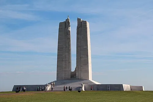 Canadian National Vimy Memorial Landmark, Givenchy-en-Gohelle22 km SE
-
Clarence River, Hauts-de-France10 km N
-
Loisne River, Hauts-de-France10 km NE
-
Forêt de Nieppe Natural site, North16 km N
-
Abbaye Notre-Dame de Beaupré Historic site, La Gorgue14 km NE
-
Lawe River, North14 km NE
Sources & licences
Data last updated: