- Population
- 1,431
- 1.4K
- Elevation
- 57 m
- above sea level
- Local time
- UTC+01:00
- Europe/Paris · UTC+01:00
- Places inside
- 2
- listed under Doingt
- Airports
- LIL Lille Airport72 km
- BVA Beauvais-Tillé airport81 km
About Doingt
Doingt is a village. Location: Arrondissement of Péronne, Somme. Population: 1,431. Elevation: 57 m. The best months to visit are June–August. The nearest airport is Lille Airport (72 km). Nearby sights include Museum of the Great War and Cologne.
Photos of Doingt
-
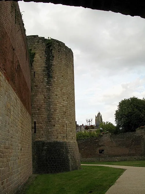
Museum of the Great War Markus3 · CC BY-SA 3.0

Climate of Doingt
Best months for sightseeingBest months for sightseeing: June–August.
This month · November
A cold month
Day 9° · Night 3° · Rain 61 mm
- Hottest month
- August (day 23°)
- Coldest month
- February (night 1°)
- Wettest month
- June (63 mm)
- Driest month
- February (45 mm)
Bars: average monthly low and high temperature. Below: precipitation. Monthly averages for 1970–2000 at about 18 km resolution, adjusted for elevation. Highlighted months are mild and relatively dry. Source: WorldClim 2.1 (CC BY 4.0).
Show values as a table
| Month | Jan | Feb | Mar | Apr | May | Jun | Jul | Aug | Sep | Oct | Nov | Dec |
|---|---|---|---|---|---|---|---|---|---|---|---|---|
| Average high (°C) | 6° | 7° | 10° | 13° | 18° | 20° | 23° | 23° | 20° | 15° | 9° | 7° |
| Average low (°C) | 1° | 1° | 3° | 4° | 8° | 11° | 13° | 12° | 10° | 7° | 3° | 2° |
| Precipitation (mm) | 54 | 45 | 52 | 47 | 59 | 63 | 55 | 50 | 57 | 60 | 61 | 62 |
How to get to Doingt
The nearest airport is Lille Airport (LIL), 72 km to the north as the crow flies. The nearest large city is Amiens, 48 km to the west.
Airports
- Lille Airport (LIL) Lesquin 72 kmnorth
- Beauvais-Tillé airport (BVA) Beauvais 81 kmsouthwest
- Charles de Gaulle International Airport (CDG) Paris (Roissy-en-France, Val-d'Oise) 106 kmsouth
Nearby large cities
- Amiens Population: 143.1K 48 kmwest
- Lille Population: 238.7K 79 kmnorth
- Reims Population: 196.6K 106 kmsoutheast
- Cergy-Pontoise Population: 183.4K 117 kmsouthwest
- Charleroi Population: 200.1K 119 kmnortheast
Straight-line distances; road distances are longer. Airport data: OurAirports.
Day trips from Doingt
Within 100 km: 190 historic and cultural sites, 257 natural sites, 222 lakes, rivers and coasts.
0–25 km10 places
- Bois des Vaux Natural site 10 kmN
- Bois de Saint-Pierre-Vaast Natural site 10 kmN
- Bois d'Havrincourt Natural site 19 kmN
- Bois Delville Natural site 16 kmNW
25–60 km111 places
- Sensée River 40 kmN
- Mont du Tremble Mountain 57 kmS
- Mont Saint-Marc Mountain 58 kmS
- Mont Ganelon Mountain 53 kmS
60–100 km548 places
- Étang de Séloignes Lake 95 kmE
- Étang d'Oise Lake 93 kmE
- Étang du Moulin Lake 96 kmE
- Étang de la Forge Gérard Lake 89 kmE
Straight-line distances.
Places in Doingt
2 placesBar: population relative to the most populous place in this list.
Cities & villages1
- Flamicourt · Village
Nearby attractions & nature
Everything nearby-
Museum of the Great War Museum, Péronne2.5 km W
-
Cologne River, Somme2.1 km W
-
Abbaye Notre-Dame de la Brelle Attraction, Biaches3.9 km W
-
Omignon River, Somme6.9 km SW
-
Bois de Saint-Pierre-Vaast Natural site, Somme10 km N
-
Bois des Vaux Natural site, Somme9.8 km N
Sources & licences
Data last updated: