- Population
- 399,290
- 399.3K
- Elevation
- 79 m
- above sea level
- Local time
- UTC+01:00
- Europe/Paris · UTC+01:00
- Places inside
- 200
- listed under Arrondissement of Caen
- Airports
- CFR Caen Carpiquet airport15 km
- DOL Deauville Normandie airport49 km
About Arrondissement of Caen
Arrondissement of Caen is a municipality. Location: Calvados, Normandy. Population: 399,290. Elevation: 79 m. The best months to visit are June–August. The nearest airport is Caen Carpiquet airport (15 km). Nearby sights include Forêt de Grimbosq and Bois de Saint-Clair.
Photos of Arrondissement of Caen
-
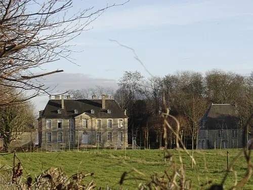
Château de la Londe RéMineur7 · CC BY-SA 3.0

Climate of Arrondissement of Caen
Best months for sightseeingBest months for sightseeing: June–August.
This month · November
A cold month
Day 11° · Night 5° · Rain 82 mm
- Hottest month
- August (day 23°)
- Coldest month
- February (night 2°)
- Wettest month
- December (84 mm)
- Driest month
- August (45 mm)
Bars: average monthly low and high temperature. Below: precipitation. Monthly averages for 1970–2000 at about 18 km resolution, adjusted for elevation. Highlighted months are mild and relatively dry. Source: WorldClim 2.1 (CC BY 4.0).
Show values as a table
| Month | Jan | Feb | Mar | Apr | May | Jun | Jul | Aug | Sep | Oct | Nov | Dec |
|---|---|---|---|---|---|---|---|---|---|---|---|---|
| Average high (°C) | 8° | 9° | 11° | 13° | 17° | 20° | 22° | 23° | 20° | 16° | 11° | 9° |
| Average low (°C) | 2° | 2° | 4° | 5° | 8° | 11° | 13° | 13° | 11° | 8° | 5° | 3° |
| Precipitation (mm) | 77 | 64 | 59 | 53 | 60 | 51 | 47 | 45 | 67 | 77 | 82 | 84 |
How to get to Arrondissement of Caen
The nearest airport is Caen Carpiquet airport (CFR), 15 km to the northwest as the crow flies. The nearest large city is Caen, 14 km to the north.
Airports
- Caen Carpiquet airport (CFR) Caen 15 kmnorthwest
- Deauville Normandie airport (DOL) Deauville 49 kmnortheast
- Jersey Airport (JER) St. Peter 137 kmwest
Nearby large cities
- Caen Population: 110.6K 14 kmnorth
- Le Havre Population: 186K 58 kmnortheast
- Rouen Population: 116.3K 113 kmnortheast
- Le Mans Population: 144.5K 125 kmsouth
- Rennes Population: 227.8K 145 kmsouthwest
Straight-line distances; road distances are longer. Airport data: OurAirports.
Day trips from Arrondissement of Caen
Within 100 km: 178 historic and cultural sites, 101 natural sites, 124 lakes, rivers and coasts.
0–25 km83 places
- Mont d'Ancre Mountain 20 kmSW
- Bois de Saint-Clair Natural site 15 kmS
- Bois du Roi Natural site 18 kmS
- Forêt de Grimbosq Natural site 8 kmW
25–60 km142 places
- Gold Beach Beach 33 kmNW
- Juno Beach Beach 31 kmN
- Sword Beach Beach 28 kmN
- Omaha Beach Beach 52 kmNW
60–100 km178 places
- Utah Beach Beach 73 kmNW
- Mont-Saint-Michel Beach 99 kmSW
- Île de Tatihou Island 88 kmNW
- Îles Saint-Marcouf Island 76 kmNW
Straight-line distances.
Arrondissement of Caen and similar cities
Side by side with cities of similar size in the same country: population, elevation and climate.
| Measure | Arrondissement of Caen | Nice | Nantes | Marne La Vallée |
|---|---|---|---|---|
| Population | 399.3K | 342.7K | 325.1K | 318.3K |
| Elevation | 79 m | 25 m | 19 m | 96 m |
| Summer day (hottest month) | 23° | 28° | 25° | 24° |
| Winter night (coldest month) | 2° | 5° | 3° | 1° |
| Annual rainfall | 766 mm | 807 mm | 794 mm | 635 mm |
| Best months | Jun–Aug | May–Sep | Jun–Sep | Jun–Sep |
| Distance | — | 834 km | 224 km | 220 km |
Climate values are 1970–2000 monthly averages; straight-line distance.
Places in Arrondissement of Caen
200 places- 61 Le Castelet 1.5K
- 62 Castine-en-Plaine 1.4K
- 63 Saint-Sylvain 1.4K
- 64 Esquay-Notre-Dame 1.4K
- 65 Feuguerolles-Bully 1.4K
- 66 Sainte-Honorine-du-Fay 1.3K
- 67 Cesny-les-Sources 1.3K
- 68 Clécy 1.3K
- 69 Cresserons 1.2K
- 70 Basly 1.1K
- 71 Colomby-Anguerny 1.1K
- 72 Maltot 1.1K
- 73 Grainville-sur-Odon 1K
- 74 Tourville-sur-Odon 1K
- 75 Pont-d'Ouilly 1K
- 76 Saint-Rémy 1K
- 77 Amayé-sur-Orne 993
- 78 Saint-Aubin-d'Arquenay 972
- 79 Saint-Germain-le-Vasson 946
- 80 Baron-sur-Odon 917
- 81 Grentheville 888
- 82 Ussy 879
- 83 Le Fresne-Camilly 873
- 84 Gouvix 827
- 85 Barbery 820
- 86 Fresney-le-Puceux 816
- 87 Villers-Canivet 791
- 88 Vendeuvre 752
- 89 Villons-les-Buissons 728
- 90 Grainville-Langannerie 719
- 91 Anisy 718
- 92 La Hoguette 718
- 93 Vimont 710
- 94 Vieux 701
- 95 Urville 655
- 96 Boulon 653
- 97 Croisilles 644
- 98 Morteaux-Coulibœuf 638
- 99 Fresné-la-Mère 619
- 100 Vacognes-Neuilly 617
- 101 Montillières-sur-Orne 605
- 102 Ouilly-le-Tesson 601
- 103 Émiéville 588
- 104 Reviers 572
- 105 Gavrus 555
- 106 Rosel 554
- 107 Avenay 553
- 108 Soumont-Saint-Quentin 541
- 109 Épaney 520
- 110 Les Moutiers-en-Cinglais 514
- 111 Esson 511
- 112 Mondrainville 502
- 113 Cauvicourt 498
- 114 Saint-Laurent-de-Condel 492
- 115 Périers-sur-le-Dan 488
- 116 Saint-Pierre-du-Bû 475
- 117 Condé-sur-Ifs 463
- 118 Versainville 461
- 119 Maizières 452
- 120 Saint-Martin-de-Mieux 440
Bar: population relative to the most populous place in this list.
Nearby attractions & nature
Everything nearby-
Forêt de Grimbosq Natural site, Calvados7.7 km W
-
Bois de Saint-Clair Natural site, Calvados15 km S
-
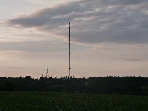 Mont Pinçon Mountain, Les Monts d'Aunay24 km SW
-
Odon River, Calvados13 km N
-
Bois du Roi Natural site, Calvados18 km S
-
Bois de Bavent Natural site, Calvados19 km NE
-
L'Aiguillon River, Calvados20 km N
-
Laison River, Calvados21 km NE
Sources & licences
Data last updated: