- Population
- 71,171
- 71.2K
- Elevation
- 211 m
- above sea level
- Local time
- UTC+01:00
- Europe/Paris · UTC+01:00
- Places inside
- 44
- listed under Arrondissement of Vire
- Airports
- CFR Caen Carpiquet airport35 km
- DOL Deauville Normandie airport83 km
About Arrondissement of Vire
Arrondissement of Vire is a municipality. Location: Calvados, Normandy. Population: 71,171. Elevation: 211 m. The best months to visit are June–August. The nearest airport is Caen Carpiquet airport (35 km). Nearby sights include Bois du Homme and Forêt l'Évêque.
Photos of Arrondissement of Vire
-
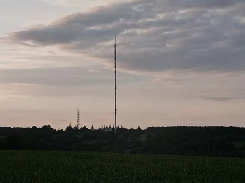
Mont Pinçon Mrobdu · CC BY-SA 4.0

Climate of Arrondissement of Vire
Best months for sightseeingBest months for sightseeing: June–August.
This month · November
A cold month
Day 11° · Night 4° · Rain 92 mm
- Hottest month
- August (day 22°)
- Coldest month
- February (night 2°)
- Wettest month
- November (92 mm)
- Driest month
- August (49 mm)
Bars: average monthly low and high temperature. Below: precipitation. Monthly averages for 1970–2000 at about 18 km resolution, adjusted for elevation. Highlighted months are mild and relatively dry. Source: WorldClim 2.1 (CC BY 4.0).
Show values as a table
| Month | Jan | Feb | Mar | Apr | May | Jun | Jul | Aug | Sep | Oct | Nov | Dec |
|---|---|---|---|---|---|---|---|---|---|---|---|---|
| Average high (°C) | 7° | 8° | 10° | 12° | 16° | 19° | 22° | 22° | 19° | 15° | 11° | 8° |
| Average low (°C) | 2° | 2° | 3° | 4° | 8° | 10° | 12° | 12° | 10° | 8° | 4° | 3° |
| Precipitation (mm) | 87 | 72 | 66 | 60 | 68 | 55 | 51 | 49 | 72 | 85 | 92 | 92 |
How to get to Arrondissement of Vire
The nearest airport is Caen Carpiquet airport (CFR), 35 km to the northeast as the crow flies. The nearest large city is Caen, 41 km to the northeast.
Airports
- Caen Carpiquet airport (CFR) Caen 35 kmnortheast
- Deauville Normandie airport (DOL) Deauville 83 kmnortheast
- Jersey Airport (JER) St. Peter 107 kmwest
Nearby large cities
- Caen Population: 110.6K 41 kmnortheast
- Le Havre Population: 186K 89 kmnortheast
- Rennes Population: 227.8K 114 kmsouthwest
- Le Mans Population: 144.5K 127 kmsoutheast
- Rouen Population: 116.3K 148 kmnortheast
Straight-line distances; road distances are longer. Airport data: OurAirports.
Day trips from Arrondissement of Vire
Within 100 km: 216 historic and cultural sites, 118 natural sites, 158 lakes, rivers and coasts.
0–25 km27 places
- Mont d'Ancre Mountain 15 kmE
- Forêt de Saint-Sever Natural site 23 kmSW
- Bois du Homme Natural site 8 kmN
- Forêt l'Évêque Natural site 9 kmNW
25–60 km181 places
- Gold Beach Beach 47 kmN
- Juno Beach Beach 50 kmNE
- Sword Beach Beach 53 kmNE
- Omaha Beach Beach 48 kmN
60–100 km284 places
- Ollonde River 79 kmNW
- Plage Collignon Beach 98 kmNW
- Plage Napoléon Beach 99 kmNW
- Plage de Collignon Beach 97 kmNW
Straight-line distances.
Arrondissement of Vire and similar cities
Side by side with cities of similar size in the same country: population, elevation and climate.
| Measure | Arrondissement of Vire | Bourges | La Rochelle | Colmar |
|---|---|---|---|---|
| Population | 71.2K | 68K | 76.8K | 65.4K |
| Elevation | 211 m | 144 m | 13 m | 193 m |
| Summer day (hottest month) | 22° | 26° | 25° | 25° |
| Winter night (coldest month) | 2° | 1° | 3° | -1° |
| Annual rainfall | 849 mm | 717 mm | 769 mm | 654 mm |
| Best months | Jun–Aug | Jun–Sep | Jun–Sep | May–Sep |
| Distance | — | 315 km | 310 km | 609 km |
Climate values are 1970–2000 monthly averages; straight-line distance.
Places in Arrondissement of Vire
44 places- 1 Vire Normandie 17.4K
- 2 Souleuvre en Bocage 8.8K
- 3 Condé-en-Normandie 6.7K
- 4 Valdallière 6.1K
- 5 Les Monts d'Aunay 4.7K
- 6 Noues de Sienne 4.5K
- 7 Villers-Bocage 3.1K
- 8 Caumont-sur-Aure 2.4K
- 9 Val d'Arry 2.3K
- 10 Aurseulles 1.9K
- 11 Cahagnes 1.4K
- 12 Seulline 1.3K
- 13 Dialan sur Chaîne 1.1K
- 14 Terres de Druance 966
- 15 Landelles-et-Coupigny 877
- 16 Val de Drôme 847
- 17 Saint-Denis-de-Méré 837
- 18 Villy-Bocage 802
- 19 Épinay-sur-Odon 626
- 20 Malherbe-sur-Ajon 549
- 21 Campagnolles 529
- 22 Monts-en-Bessin 417
- 23 Landes-sur-Ajon 413
- 24 Bonnemaison 404
- 25 Longvillers 359
- 26 Tracy-Bocage 305
- 27 Maisoncelles-Pelvey 262
- 28 Courvaudon 239
- 29 Saint-Aubin-des-Bois 237
- 30 Amayé-sur-Seulles 227
- 31 Brémoy 226
- 32 La Villette 223
- 33 Beaumesnil 202
- 34 Parfouru-sur-Odon 197
- 35 Saint-Pierre-du-Fresne 197
- 36 Le Mesnil-Robert 194
- 37 Maisoncelles-sur-Ajon 191
- 38 Saint-Louet-sur-Seulles 150
- 39 Les Loges 124
- 40 Sainte-Marie-Outre-l'Eau 122
- 41 Pontécoulant 81
- 42 Le Mesnil-au-Grain 75
- 43 Pont-Bellanger 65
- 44 Périgny 58
Bar: population relative to the most populous place in this list.
Nearby attractions & nature
Everything nearby-
Bois du Homme Natural site, Calvados8.3 km N
-
Forêt l'Évêque Natural site, Calvados9.1 km NW
-
Souleuvre River, Calvados8.2 km W
-
Bois de Buron Natural site, Calvados9.9 km NE
-
Allière River, Calvados12 km SW
-
Couvent de Torigni-sur-Vire Historic site, Torigny-les-Villes18 km NW
-
Château de Torigny-sur-Vire Historic site, Torigny-les-Villes18 km NW
-
Abbaye de Torigny Historic site, Torigny-les-Villes18 km NW
Sources & licences
Data last updated: