- Population
- 225,544
- 225.5K
- Elevation
- 150 m
- above sea level
- Local time
- UTC+01:00
- Europe/Paris · UTC+01:00
- Places inside
- 297
- listed under Arrondissement of Bernay
- Airports
- DOL Deauville Normandie airport45 km
- CFR Caen Carpiquet airport80 km
About Arrondissement of Bernay
Arrondissement of Bernay is a municipality. Location: Eure, Normandy. Population: 225,544. Elevation: 150 m. The best months to visit are June–September. The nearest airport is Deauville Normandie airport (45 km). Nearby sights include Charentonne River and Forêt de Beaumont.
Photos of Arrondissement of Bernay
-
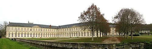
Bec Abbey Roland Brierre · CC BY-SA 3.0

Climate of Arrondissement of Bernay
Best months for sightseeingBest months for sightseeing: June–September.
This month · November
A cold month
Day 10° · Night 5° · Rain 73 mm
- Hottest month
- August (day 22°)
- Coldest month
- February (night 2°)
- Wettest month
- December (77 mm)
- Driest month
- July (49 mm)
Bars: average monthly low and high temperature. Below: precipitation. Monthly averages for 1970–2000 at about 18 km resolution, adjusted for elevation. Highlighted months are mild and relatively dry. Source: WorldClim 2.1 (CC BY 4.0).
Show values as a table
| Month | Jan | Feb | Mar | Apr | May | Jun | Jul | Aug | Sep | Oct | Nov | Dec |
|---|---|---|---|---|---|---|---|---|---|---|---|---|
| Average high (°C) | 7° | 7° | 10° | 13° | 16° | 19° | 22° | 22° | 19° | 15° | 10° | 8° |
| Average low (°C) | 2° | 2° | 3° | 5° | 8° | 11° | 13° | 13° | 11° | 8° | 5° | 3° |
| Precipitation (mm) | 70 | 62 | 54 | 51 | 57 | 55 | 49 | 50 | 59 | 75 | 73 | 77 |
Other places to visit in this season: June July August September
How to get to Arrondissement of Bernay
The nearest airport is Deauville Normandie airport (DOL), 45 km to the northwest as the crow flies. For international flights: Beauvais-Tillé airport (BVA) (114 km). The nearest large city is Rouen, 50 km to the northeast.
Airports
- Deauville Normandie airport (DOL) Deauville 45 kmnorthwest
- Caen Carpiquet airport (CFR) Caen 80 kmwest
- Beauvais-Tillé airport (BVA) Beauvais 114 kmeast
Nearby large cities
- Rouen Population: 116.3K 50 kmnortheast
- Le Havre Population: 186K 58 kmnorthwest
- Caen Population: 110.6K 73 kmwest
- Cergy-Pontoise Population: 183.4K 105 kmeast
- Saint-Quentin-en-Yvelines Population: 146.6K 108 kmeast
Straight-line distances; road distances are longer. Airport data: OurAirports.
Day trips from Arrondissement of Bernay
Within 100 km: 245 historic and cultural sites, 129 natural sites, 129 lakes, rivers and coasts.
0–25 km10 places
- Forêt de Conches Natural site 25 kmSE
- Forêt de Cinglais Natural site 22 kmSW
- Bois de Broglie Natural site 12 kmS
- Forêt de Beaumont Natural site 11 kmSE
25–60 km175 places
- Biotropica Natural site 47 kmNE
- Plage du Temple Beach 57 kmW
- Plage du Casino Beach 56 kmNW
- Plage de Deauville Beach 50 kmNW
60–100 km318 places
- Dive River 99 kmS
- Cloche River 87 kmS
- Gold Beach Beach 89 kmW
- Juno Beach Beach 82 kmW
Straight-line distances.
Arrondissement of Bernay and similar cities
Side by side with cities of similar size in the same country: population, elevation and climate.
| Measure | Arrondissement of Bernay | Rennes | Paris 15 Vaugirard | Lille |
|---|---|---|---|---|
| Population | 225.5K | 227.8K | 229.7K | 238.7K |
| Elevation | 150 m | 39 m | 47 m | 20 m |
| Summer day (hottest month) | 22° | 24° | 25° | 23° |
| Winter night (coldest month) | 2° | 3° | 2° | 1° |
| Annual rainfall | 732 mm | 738 mm | 632 mm | 716 mm |
| Best months | Jun–Sep | Jun–Sep | May–Sep | Jun–Aug |
| Distance | — | 203 km | 125 km | 243 km |
Climate values are 1970–2000 monthly averages; straight-line distance.
Places in Arrondissement of Bernay
297 places- 61 Saint-Didier-des-Bois 885
- 62 Saint-Georges-du-Vièvre 879
- 63 Illeville-sur-Montfort 876
- 64 Sainte-Colombe-la-Commanderie 835
- 65 Combon 821
- 66 Montreuil-l'Argillé 812
- 67 Hondouville 799
- 68 Saint-Mards-de-Blacarville 797
- 69 Saint-Philbert-sur-Risle 782
- 70 Trouville-la-Haule 769
- 71 Piseux 768
- 72 Fatouville-Grestain 762
- 73 Montfort-sur-Risle 756
- 74 Tourville-sur-Pont-Audemer 736
- 75 Courbépine 732
- 76 Fiquefleur-Équainville 713
- 77 Bois-Arnault 711
- 78 Plasnes 709
- 79 Berville-sur-Mer 707
- 80 Saint-Aubin-d'Écrosville 704
- 81 Honguemare-Guenouville 697
- 82 Saint-Aubin-sur-Quillebeuf 696
- 83 Bosgouet 685
- 84 Étréville 681
- 85 Calleville 673
- 86 Canappeville 667
- 87 Beaumontel 666
- 88 Le Lesme 666
- 89 Bosrobert 658
- 90 Les Baux-de-Breteuil 658
- 91 Sainte-Opportune-du-Bosc 656
- 92 La Vieille-Lyre 655
- 93 Vraiville 655
- 94 Foulbec 652
- 95 La Neuville-du-Bosc 651
- 96 Pont-Authou 650
- 97 Quittebeuf 648
- 98 Condé-sur-Risle 636
- 99 Brosville 627
- 100 Écaquelon 618
- 101 Saint-Maclou 617
- 102 Saint-Pierre-de-Cormeilles 616
- 103 Drucourt 603
- 104 Crosville-la-Vieille 596
- 105 Glos-sur-Risle 586
- 106 Caorches-Saint-Nicolas 585
- 107 La Harengère 584
- 108 Émanville 583
- 109 Brestot 575
- 110 Sainte-Marie-d'Attez 575
- 111 La Neuve-Lyre 573
- 112 Ambenay 571
- 113 Épégard 569
- 114 Saint-Pierre-du-Val 568
- 115 Bâlines 563
- 116 Vitot 558
- 117 Bémécourt 556
- 118 Crestot 556
- 119 Saint-Étienne-l'Allier 555
- 120 Grosley-sur-Risle 524
Bar: population relative to the most populous place in this list.
Nearby attractions & nature
Everything nearby-
Charentonne River River, Eure6.9 km E
-
Forêt de Beaumont Natural site, Eure11 km SE
-
Bois de Broglie Natural site, Eure12 km S
-
Forêt de Conches Natural site, Eure25 km SE
-
Château de Mailloc Historic site, Valorbiquet24 km W
-
Forêt de Cinglais Natural site, Calvados22 km SW
Sources & licences
Data last updated: