- Population
- 135,095
- 135.1K
- Elevation
- 179 m
- above sea level
- Local time
- UTC+01:00
- Europe/Paris · UTC+01:00
- Places inside
- 134
- listed under Arrondissement of Avranches
- Airports
- RNS Rennes-Saint-Jacques Airport78 km
- CFR Caen Carpiquet airport79 km
About Arrondissement of Avranches
Arrondissement of Avranches is a municipality. Location: Manche, Normandy. Population: 135,095. Elevation: 179 m. The best months to visit are June–September. The nearest airport is Rennes-Saint-Jacques Airport (78 km). Nearby sights include Mont Saint-Michel and Glénon.
Climate of Arrondissement of Avranches
Best months for sightseeingBest months for sightseeing: June–September.
This month · November
A cold month
Day 11° · Night 5° · Rain 90 mm
- Hottest month
- August (day 22°)
- Coldest month
- February (night 2°)
- Wettest month
- November (90 mm)
- Driest month
- July (47 mm)
Bars: average monthly low and high temperature. Below: precipitation. Monthly averages for 1970–2000 at about 18 km resolution, adjusted for elevation. Highlighted months are mild and relatively dry. Source: WorldClim 2.1 (CC BY 4.0).
Show values as a table
| Month | Jan | Feb | Mar | Apr | May | Jun | Jul | Aug | Sep | Oct | Nov | Dec |
|---|---|---|---|---|---|---|---|---|---|---|---|---|
| Average high (°C) | 7° | 8° | 11° | 13° | 16° | 19° | 21° | 22° | 19° | 15° | 11° | 8° |
| Average low (°C) | 2° | 2° | 3° | 5° | 8° | 10° | 13° | 13° | 11° | 8° | 5° | 3° |
| Precipitation (mm) | 80 | 66 | 62 | 58 | 66 | 50 | 47 | 47 | 66 | 82 | 90 | 85 |
Other places to visit in this season: June July August September
How to get to Arrondissement of Avranches
The nearest airport is Rennes-Saint-Jacques Airport (RNS), 78 km to the southwest as the crow flies. The nearest large city is Rennes, 71 km to the southwest.
Airports
- Rennes-Saint-Jacques Airport (RNS) Saint-Jacques-de-la-Lande, Ille-et-Vilaine 78 kmsouthwest
- Caen Carpiquet airport (CFR) Caen 79 kmnortheast
- Jersey Airport (JER) St. Peter 93 kmnorthwest
Nearby large cities
- Rennes Population: 227.8K 71 kmsouthwest
- Caen Population: 110.6K 84 kmnortheast
- Le Mans Population: 144.5K 129 kmsoutheast
- Le Havre Population: 186K 133 kmnortheast
- Angers Population: 168.3K 143 kmsouth
Straight-line distances; road distances are longer. Airport data: OurAirports.
Day trips from Arrondissement of Avranches
Within 100 km: 209 historic and cultural sites, 116 natural sites, 178 lakes, rivers and coasts.
0–25 km17 places
- Mont-Saint-Michel Beach 22 kmW
- Forêt de Saint-Sever Natural site 21 kmNE
- Forêt de Mortain Natural site 23 kmE
- Sélune River 14 kmW
25–60 km115 places
- Plage de l'Éventail Beach 59 kmW
- Plage Verger Beach 49 kmW
- Île des Rimains Island 45 kmW
- Grande Île Island 51 kmNW
60–100 km371 places
- Ollonde River 81 kmNW
- Gold Beach Beach 88 kmNE
- Juno Beach Beach 93 kmNE
- Sword Beach Beach 96 kmNE
Straight-line distances.
Arrondissement of Avranches and similar cities
Side by side with cities of similar size in the same country: population, elevation and climate.
| Measure | Arrondissement of Avranches | Paris 14 Observatoire | Paris 12 Reuilly | Paris 11 Popincourt |
|---|---|---|---|---|
| Population | 135.1K | 136.5K | 138K | 138.2K |
| Elevation | 179 m | 70 m | 46 m | 43 m |
| Summer day (hottest month) | 22° | 25° | 25° | 25° |
| Winter night (coldest month) | 2° | 2° | 2° | 2° |
| Annual rainfall | 799 mm | 643 mm | 641 mm | 641 mm |
| Best months | Jun–Sep | Jun–Sep | May–Sep | May–Sep |
| Distance | — | 261 km | 265 km | 265 km |
Climate values are 1970–2000 monthly averages; straight-line distance.
Places in Arrondissement of Avranches
134 places- 61 Pontaubault 542
- 62 Sacey 522
- 63 Saint-Jean-de-la-Haize 510
- 64 Saint-Pois 509
- 65 Reffuveille 505
- 66 Saint-Laurent-de-Cuves 483
- 67 La Chaise-Baudouin 480
- 68 Muneville-sur-Mer 469
- 69 Anctoville-sur-Boscq 457
- 70 Savigny-le-Vieux 445
- 71 Aucey-la-Plaine 433
- 72 Saint-Aubin-des-Préaux 431
- 73 Céaux 429
- 74 Genêts 429
- 75 Le Neufbourg 418
- 76 Beauvoir 413
- 77 Saint-Jean-le-Thomas 408
- 78 Beauchamps 404
- 79 Saint-Cyr-du-Bailleul 394
- 80 Le Tanu 386
- 81 Subligny 375
- 82 Lapenty 374
- 83 Champeaux 364
- 84 Le Grippon 364
- 85 Saint-Senier-de-Beuvron 363
- 86 Saint-Sauveur-la-Pommeraye 361
- 87 Chanteloup 355
- 88 Marcilly 332
- 89 Saint-Barthélemy 330
- 90 Saint-Martin-le-Bouillant 317
- 91 Saint-Michel-de-Montjoie 307
- 92 Crollon 301
- 93 Tanis 301
- 94 Chaulieu 299
- 95 Moulines 294
- 96 Cuves 284
- 97 Le Loreur 278
- 98 Servon 278
- 99 La Godefroy 271
- 100 Le Mesnillard 271
- 101 Le Luot 265
- 102 Le Mesnil-Ozenne 264
- 103 Montjoie-Saint-Martin 248
- 104 La Mouche 245
- 105 La Chapelle-Cécelin 243
- 106 Gathemo 240
- 107 Les Cresnays 232
- 108 Courtils 225
- 109 Le Fresne-Poret 214
- 110 Perriers-en-Beauficel 214
- 111 Saint-Georges-de-Livoye 200
- 112 Le Petit-Celland 199
- 113 Équilly 194
- 114 Huisnes-sur-Mer 191
- 115 Hocquigny 184
- 116 Le Mesnil-Aubert 183
- 117 Le Mesnil-Adelée 171
- 118 La Meurdraquière 169
- 119 Vernix 160
- 120 La Chapelle-Urée 152
Bar: population relative to the most populous place in this list.
Nearby attractions & nature
Everything nearby-
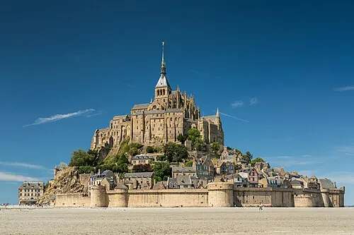 Mont Saint-Michel Island, Manche23 km W
-
Glénon River, Manche8.7 km NE
-
Beuvron River, Manche11 km SW
-
Airon River, Manche13 km SE
-
Forêt de Mortain Natural site, Manche23 km E
-
Cance River, Manche21 km E
-
Sélune River, Normandy14 km W
-
Couesnon River, Manche23 km W
Sources & licences
Data last updated: