- Elevation
- 683 m
- above sea level
- Local time
- UTC+01:00
- Europe/Berlin · UTC+01:00
- Airports
- BSL EuroAirport Basel–Mulhouse–Freiburg32 km
- ZRH Zürich Airport62 km
About Hof
Hof is a village. Location: Fröhnd, Landkreis Lörrach. Elevation: 683 m. The best months to visit are June–August. The nearest airport is EuroAirport Basel–Mulhouse–Freiburg (32 km). Nearby sights include Honeck and Bubshorn.
Photos of Hof
-
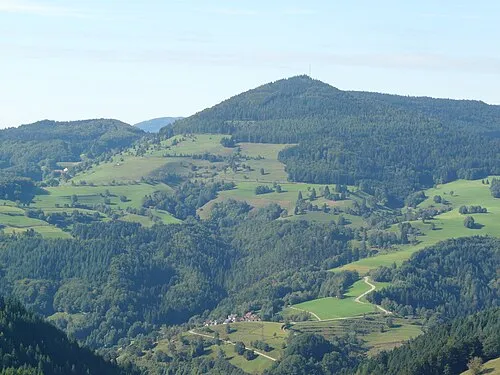
Zeller Blauen SEM de-wiki · CC BY 3.0 -
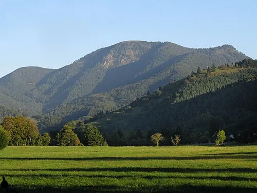
Belchen Andreas Schwarzkopf edited by Milseburg · CC BY-SA 3.0


Climate of Hof
Best months for sightseeingBest months for sightseeing: June–August.
This month · November
A wet month
Day 7° · Night 0° · Rain 160 mm
- Hottest month
- July (day 21°)
- Coldest month
- January (night -4°)
- Wettest month
- December (177 mm)
- Driest month
- September (110 mm)
Bars: average monthly low and high temperature. Below: precipitation. Monthly averages for 1970–2000 at about 18 km resolution, adjusted for elevation. Highlighted months are mild and relatively dry. Source: WorldClim 2.1 (CC BY 4.0).
Show values as a table
| Month | Jan | Feb | Mar | Apr | May | Jun | Jul | Aug | Sep | Oct | Nov | Dec |
|---|---|---|---|---|---|---|---|---|---|---|---|---|
| Average high (°C) | 3° | 4° | 7° | 11° | 16° | 19° | 21° | 21° | 17° | 13° | 7° | 4° |
| Average low (°C) | -4° | -3° | -1° | 2° | 6° | 9° | 11° | 11° | 8° | 4° | 0° | -2° |
| Precipitation (mm) | 150 | 143 | 125 | 123 | 137 | 144 | 134 | 116 | 110 | 138 | 160 | 177 |
How to get to Hof
The nearest airport is EuroAirport Basel–Mulhouse–Freiburg (BSL), 32 km to the southwest as the crow flies. The nearest large city is Freiburg im Breisgau, 25 km to the north.
Airports
- EuroAirport Basel–Mulhouse–Freiburg (BSL) Bâle / Mulhouse 32 kmsouthwest
- Zürich Airport (ZRH) Zurich 62 kmsoutheast
- Strasbourg Airport (SXB) Strasbourg 87 kmnorth
Nearby large cities
- Freiburg im Breisgau Population: 237.5K 25 kmnorth
- Basel Population: 177.6K 33 kmsouthwest
- Mulhouse Population: 111.4K 41 kmwest
- Zurich Population: 415.4K 68 kmsoutheast
- Winterthur Population: 111.8K 71 kmsoutheast
Straight-line distances; road distances are longer. Airport data: OurAirports.
Day trips from Hof
Within 100 km: 595 historic and cultural sites, 2,068 natural sites, 616 lakes, rivers and coasts.
0–25 km307 places
- Breitsee Lake 22 kmS
- Ägelsee Lake 23 kmS
- Breitsee Lake 22 kmS
- Möhlin Bach River 21 kmS
25–60 km806 places
- Fahr Abbey Attraction 59 kmSE
- Arbeiterstrandbad Tennwil Beach 58 kmSE
- Trübelbachweier Lake 60 kmS
- Büselweier Lake 43 kmSE
60–100 km2,166 places
- Kleiner Bremgartenwald Mountain 95 kmS
- Mainau Island 100 kmE
- Dominikanerinsel Konstanz Island 99 kmE
- Strandbad Steckborn Beach 84 kmE
Straight-line distances.
Nearby attractions & nature
Everything nearby-
Honeck Mountain, Fröhnd2.1 km W
-
Bubshorn Mountain, Zell im Wiesental2.4 km S
-
Schneckenkopf Mountain, Fröhnd3 km E
-
Hirschkopf Mountain, Kleines Wiesental2.9 km SW
-
Gscheidkopf Mountain, Fröhnd3.9 km E
-
Zeller Blauen Mountain, Zell im Wiesental4.4 km S
Sources & licences
Data last updated: