- Elevation
- 319 m
- above sea level
- Local time
- UTC+01:00
- Europe/Berlin · UTC+01:00
- Airports
- STR Stuttgart Airport65 km
- MHG Mannheim-City Airport84 km
About Löschenhirschbach
Löschenhirschbach is a village. Location: Neuenstein, Hohenlohekreis. Elevation: 319 m. The best months to visit are June–August. The nearest airport is Stuttgart Airport (65 km). Nearby sights include Neuenstein, Schloss and Eichberg.
Photos of Löschenhirschbach
-
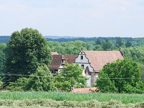
Schloß Hermersberg Geryones · CC0

Climate of Löschenhirschbach
Best months for sightseeingBest months for sightseeing: June–August.
This month · November
A cold month
Day 7° · Night 1° · Rain 75 mm
- Hottest month
- July (day 23°)
- Coldest month
- January (night -2°)
- Wettest month
- June (87 mm)
- Driest month
- April (62 mm)
Bars: average monthly low and high temperature. Below: precipitation. Monthly averages for 1970–2000 at about 18 km resolution, adjusted for elevation. Highlighted months are mild and relatively dry. Source: WorldClim 2.1 (CC BY 4.0).
Show values as a table
| Month | Jan | Feb | Mar | Apr | May | Jun | Jul | Aug | Sep | Oct | Nov | Dec |
|---|---|---|---|---|---|---|---|---|---|---|---|---|
| Average high (°C) | 3° | 5° | 9° | 13° | 18° | 21° | 23° | 23° | 19° | 13° | 7° | 4° |
| Average low (°C) | -2° | -2° | 1° | 3° | 8° | 11° | 13° | 12° | 9° | 5° | 1° | -1° |
| Precipitation (mm) | 71 | 66 | 71 | 62 | 80 | 87 | 81 | 64 | 64 | 78 | 75 | 86 |
How to get to Löschenhirschbach
The nearest airport is Stuttgart Airport (STR), 65 km to the southwest as the crow flies. The nearest large city is Heilbronn, 29 km to the west.
Airports
- Stuttgart Airport (STR) Stuttgart 65 kmsouthwest
- Mannheim-City Airport (MHG) Mannheim 84 kmwest
- Nuremberg Airport (NUE) Nuremberg 111 kmeast
Nearby large cities
- Heilbronn Population: 120.7K 29 kmwest
- Stuttgart Population: 612.7K 58 kmsouthwest
- Würzburg Population: 133.7K 68 kmnorth
- Heidelberg Population: 143.3K 69 kmwest
- Pforzheim Population: 119.3K 76 kmsouthwest
Straight-line distances; road distances are longer. Airport data: OurAirports.
Day trips from Löschenhirschbach
Within 100 km: 1,393 historic and cultural sites, 3,634 natural sites, 863 lakes, rivers and coasts.
0–25 km213 places
- Hessental Concentration Camp Historic site 18 kmSE
- Wolfsberg Mountain 24 kmSW
- Wildenberg Mountain 22 kmW
- Waldenburger Berge Mountain 10 kmS
25–60 km1,671 places
- Umpfer River 37 kmN
- Uzbach River 55 kmNE
- Großer Lindleinsee Lake 48 kmNE
- Annasee Lake 26 kmSW
60–100 km4,006 places
- Elsenz River 62 kmW
- Lauter River 62 kmS
- Lauter River 92 kmS
- Friesenheimer Insel Island 90 kmW
Straight-line distances.
Nearby attractions & nature
Everything nearby-
Neuenstein, Schloss Historic site, Neuenstein2.7 km SW
-
Eichberg Mountain, Neuenstein3.8 km S
-
Theresienberg Mountain, Waldenburg3.8 km SE
-
Schloß Hermersberg Historic site, Niedernhall5.9 km N
-
Waldenburg Water Tower Landmark, Waldenburg4.6 km S
-
Sendeturm Waldenburg Landmark, Waldenburg4.6 km S
Sources & licences
Data last updated: